If you have driven the Manali to Leh highway, you already know that the road throws everything at you. Hairpin bends at Gata Loops, the punishing climb over Lachalung La, the dusty chaos of Sarchu, and hours of white-knuckle driving at 30 kmph. Then, somewhere after Pang, the landscape does something completely unexpected. It opens up. The mountains step back, the road straightens out, and you find yourself on a 40-kilometer stretch of flat, beautifully paved tarmac at 4,800 meters above sea level. Welcome to More Plains (also called Moore Plains), the most surreal and peaceful stretch of the entire Manali-Leh highway.
Let's quickly dive into the details:
What Are More Plains on the Manali-Leh Highway?
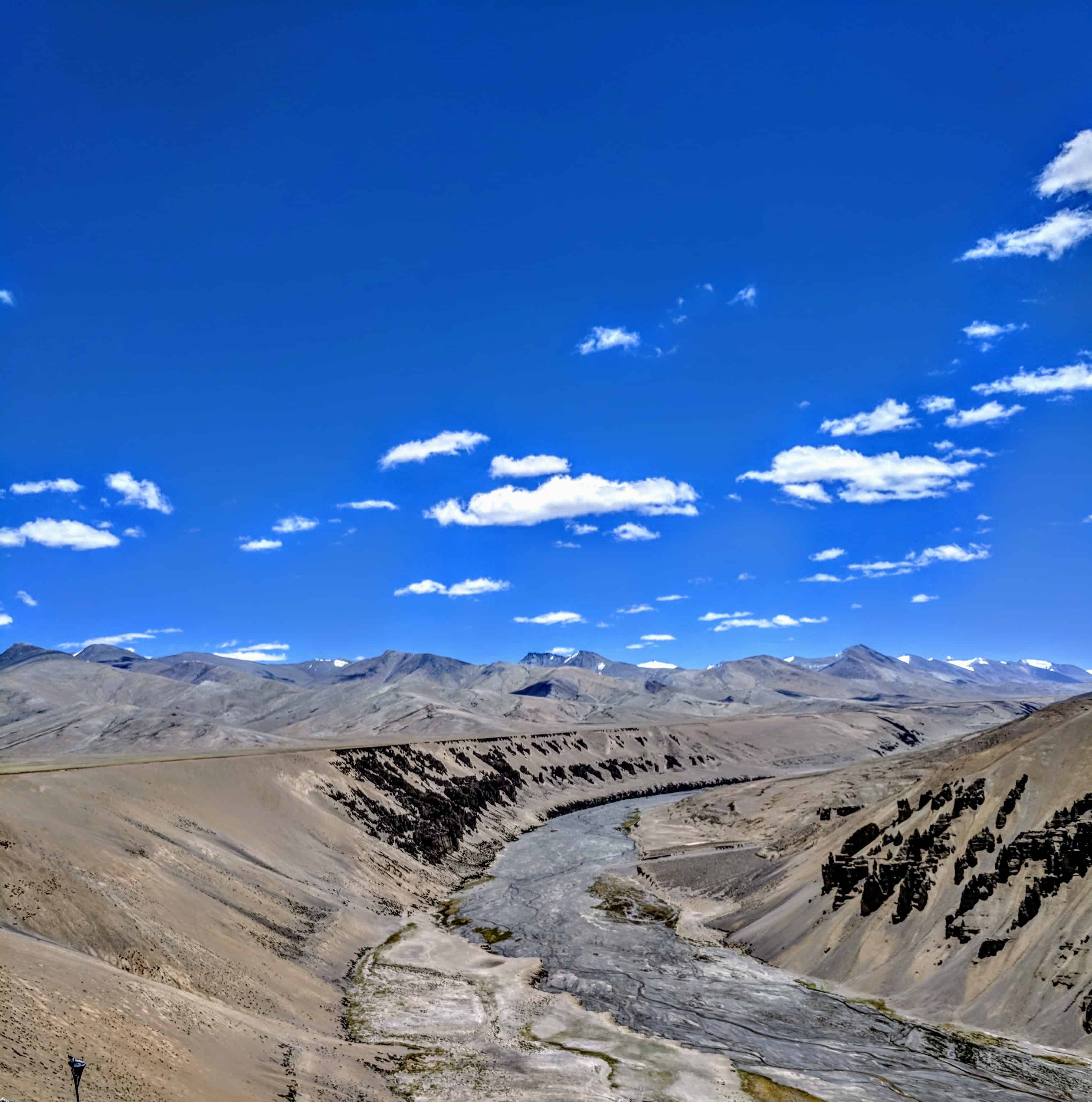
More Plains is a high-altitude plateau situated between Pang (15,400 ft) and Tanglang La Pass (17,480 ft) on the Manali-Leh Highway in Ladakh. The plateau sits at an average elevation of 4,800 meters (15,750 ft) and stretches for approximately 40 kilometers along the highway. It is often called the “table-top of Earth” because of its flat, desert-like terrain surrounded by distant barren mountains on all sides.
After days of navigating mountain passes where you are constantly looking up, More Plains flips the script. Here, the land is flat, the sky is enormous, and the road stretches straight into the horizon. For bikers, self-drivers, and passengers alike, this visual shift is nothing short of a system reset. I remember hitting the brakes the first time I saw it. My brain genuinely needed a few seconds to believe what my eyes were showing me.
How Do You Reach More Plains from Manali or Leh?
More Plains is accessible only via the Manali-Leh Highway, which typically opens in late May or early June and remains operational until September. There is no alternate route to reach this plateau.
From Manali (via Atal Tunnel): The route goes through Sissu, Jispa/Keylong, Sarchu, Gata Loops, Nakee La and Lachalung La, and then Pang. More Plains begins about 4 km after Pang on the climb towards Tanglang La. The total distance from Manali to More Plains is approximately 300 km, and most travelers reach here on Day 2 of the Manali-Leh road trip if starting from Sarchu, or Day 3 if night-halting at Jispa.
From Leh: Drive towards Upshi on the Leh-Manali Highway, cross Tanglang La Pass, and descend onto More Plains. The distance from Leh to More Plains is roughly 160 km, which takes about 5-6 hours depending on road conditions. This is the reverse route and is equally stunning.
Important: The Atal Tunnel (opened October 2020) has made Manali to Sarchu a single-day drive. You no longer need a Rohtang Pass permit for this route. However, I strongly recommend halting at Jispa or Keylong instead of Sarchu for your first night stop, especially if you are not accustomed to high altitudes. Sarchu sits at 14,070 ft, and jumping to that altitude on Day 1 increases your risk of Acute Mountain Sickness (AMS).
What Makes More Plains So Special?
I have been on many stretches of the Manali-Leh highway, and I can say with confidence that More Plains is the most emotionally impactful part of the entire journey. Here is why.
After the strenuous drive from Sarchu to Pang, which is sprinkled with the joys of Gata Loops and the pain points of Nakee La and Lachalung La (the drive after Lachalung La is legitimately the worst section), nature suddenly rewards you. After Pang, the roads instantaneously improve. You climb through a few bends with towering mountains all around, and then, you witness a view that literally makes you hit the brakes.
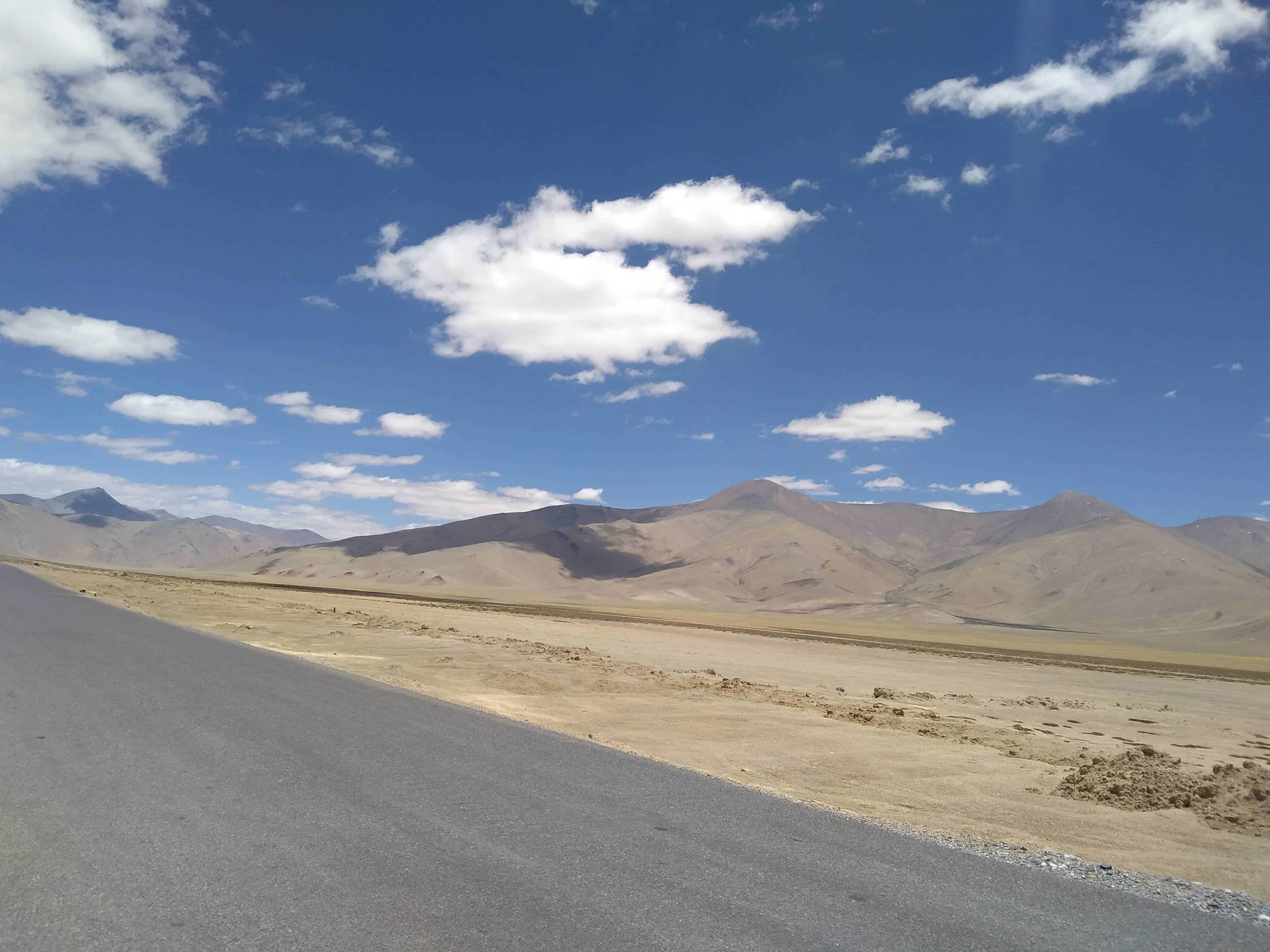
A straight stretch of road leading into the horizon. Massive plain land on both sides of the beautifully paved road. Barren Himalayas in the distance keeping the clouds company. No trees, no villages, no signboards. Just you, the road, and a silence so deep that you can hear your own breathing over the engine.
What Is the Best Time to Visit More Plains?
The Manali-Leh Highway typically opens in late May or early June and closes by mid-October, depending on snowfall and BRO clearance operations. More Plains is accessible only during this window. Here is a month-by-month breakdown.
June: The highway is freshly opened. Some sections between Sarchu and Pang may still have snow patches. More Plains itself is usually clear by mid-June. Expect cold winds and occasional rain. This is a good month for fewer crowds.
July-August: Peak season. The road is at its best condition thanks to BRO maintenance by Project Deepak (Manali to Sarchu) and Project Himank (Leh to Sarchu). Skies are mostly clear in the morning, with clouds building by afternoon. Keep in mind that landslides near Sarchu and Pang can cause delays, especially after heavy rain.
September: Excellent month for this stretch. Clear skies, stable weather, fewer tourists. The golden-brown landscape looks its best under crisp autumn light. If you can plan your Ladakh trip in September, do it.
October: Risky. The highway can close anytime due to early snowfall at Baralacha La or Tanglang La. Not recommended unless you are experienced and prepared for being stuck.
What Should You Know Before Driving Through More Plains?
More Plains looks inviting, and the smooth road tempts you to speed up after days of driving at 30 kmph. Resist that temptation. Here are practical things you should keep in mind.


Do not over-speed. The road is straight and smooth, but at 15,750 ft, your reaction time is slower than normal. Sudden bumps or low-lying dips in the road can catch you off guard. Army convoys also use this stretch frequently, and overtaking at high speed on a narrow road is dangerous.
Altitude awareness. More Plains sits at nearly 4,800 meters. You are at significant altitude here. If you skipped proper acclimatization at lower stops, AMS symptoms can hit hard on this stretch. Headache, nausea, dizziness. Keep Diamox handy if your doctor has prescribed it, and drink plenty of water.
![How to safely carry luggage or extra fuel on Spiti or Ladakh Bike Ride? [10 Safety Tips]](https://discoverwithdheeraj.com/yt_vid_thumbs/ladakh/87.png)
No services on the plateau. There are no shops, fuel pumps, dhabas, or mobile network on More Plains. The nearest services are at Pang (basic dhabas and tent camps) or further ahead at Rumtse/Upshi. Carry water, snacks, and emergency supplies. The last reliable fuel pump before this stretch is at Tandi (32 km before Keylong), so plan your fuel carefully.
Wind and cold. Even in July, the wind on More Plains can be fierce. Temperatures drop sharply, especially in the morning and evening. If you step out for photos (and you will), carry a windbreaker. Sand and dust kicked up by passing vehicles can be harsh on exposed skin and camera equipment.
No off-roading. Some people are tempted to drive off-road on the adjacent flat ground, pop wheelies, or do tricks. The terrain looks flat but has hidden undulations and soft patches that can trap your vehicle. Stick to the road.
How Did I Experience More Plains?
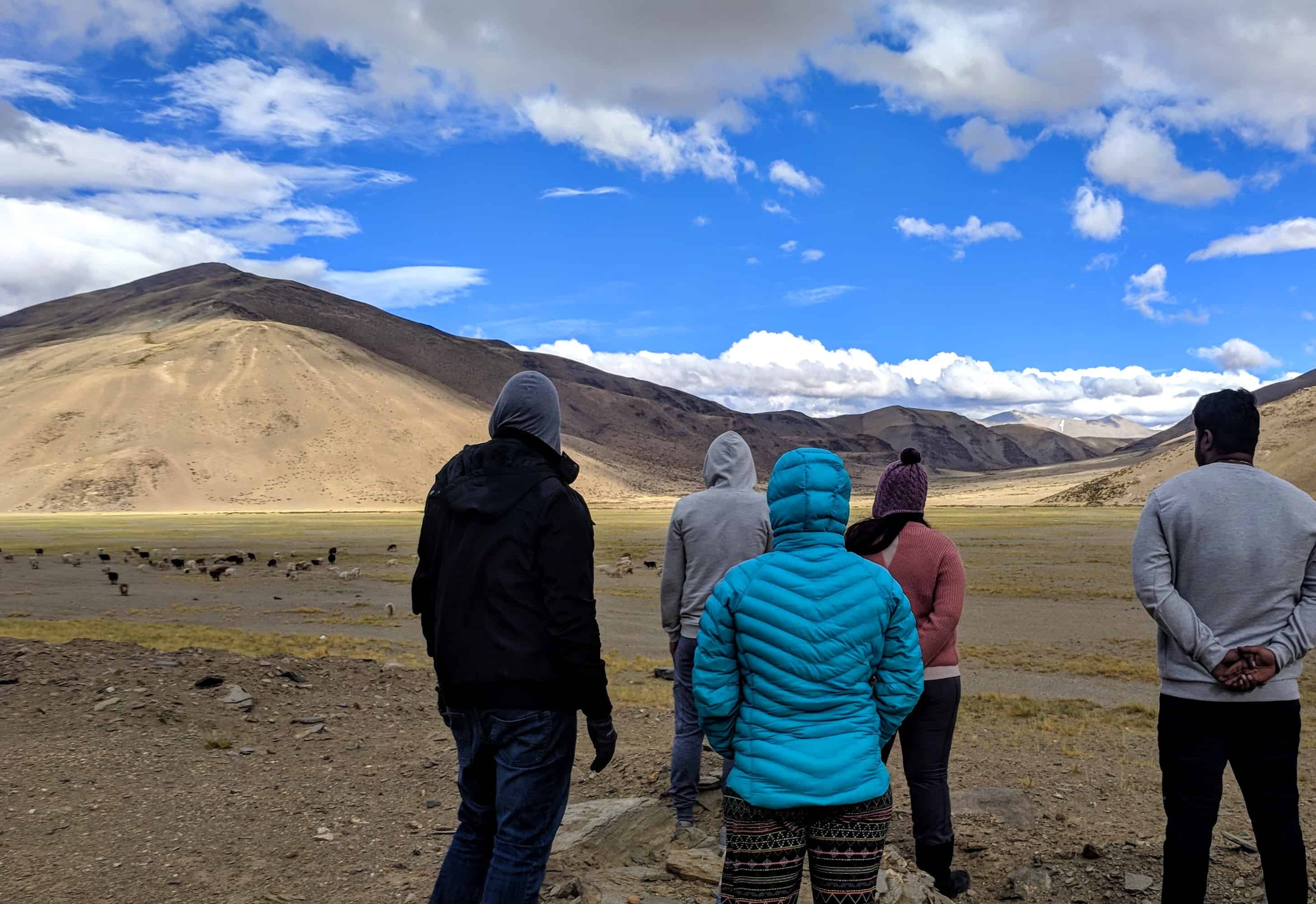
By the time we crossed Pang, we were exhausted. The drive from Sarchu through Gata Loops and over Lachalung La had taken everything out of us. But the moment More Plains began, we were flabbergasted at first, and then put into such a state of calm that our entire group fell asleep instantaneously. The views took all our pain away. It was so peaceful and so visually overwhelming that the brain simply shut down and surrendered to the beauty.
Since it was a bright and blue, sunny day, I could read the scales of the mountains. In moments like these, I wish I was more artistic. I wanted to sit and paint an oil painting. However, in comparison to me, my far more adventurous and cooler better-half wanted to ride a horse on the endless stretch of heaven.
My dog-lover friends imagined how happy their pup would be with so much land to explore. My best friend was still feeling AMS (how that was possible at this point, I am not sure), but was a champ nonetheless.
This was also the place where our novice drivers (at least in the Himalayan region) got to drive and check that bucket list item off. Slow and steady, keeping in mind a few low-lying bumps on the road, we saw no one around. Or maybe we were too enamored to notice anyone else. We rolled on, never wanting the view in front of us to change, yet watching it unfold in pure amazement.
With almost everyone asleep, I felt my eyes getting heavier. But not wanting to miss out on a single movement and the complete stillness, I just stared, overwhelmed and mesmerized. The 40+ km stretch could have gone on forever, on loop, for the rest of my life, and I would have been a happy camper.
Why Do Travelers Call More Plains the “Table-Top of Earth”?
The name makes sense the moment you are standing on it. At nearly 16,000 ft, this plateau is one of the highest flat expanses you will ever drive across. The ground stretches perfectly flat in every direction, with the horizon line sitting impossibly far away. Mountains ring the edges like distant walls, but between you and them, there is nothing. No undulation, no rivers, no structures. Just a golden-brown desert floor and a ribbon of black tarmac cutting through it.
There is a philosophical quality to this place that is hard to describe. You begin to indulge in a comfortable stillness, unfazed by the concept of time. You stand for hours on end, trying to experience the antiquity and endurance of the universe. You realize happiness can never be material. For there will never be a moment from here on out that you will not crave this emotion of witnessing a passing moment and comfortable eternity at the same time.
Unable to define this place, humanity has not left its mark. More Plains belongs to no one. Yet, no one can cross this place and not belong here. Such is the charm that Moore Plains leaves you with. You willingly leave a part of you behind.

Is It Safe to Camp at More Plains?
While the flat terrain looks like a perfect campsite, camping on More Plains is not recommended for most travelers. The altitude of 15,750 ft makes overnight stays risky if you are not properly acclimatized. Night temperatures can drop well below freezing even in summer, and the wind chill makes it worse. There is no water source, no shelter, and no help if something goes wrong.
If you absolutely must camp, come prepared with a 4-season tent, sleeping bags rated for -15C or lower, and adequate food and water. Keep in mind that you are several hours away from any medical facility. The nearest options are the army camp at Pang (basic first aid) or Upshi/Leh (proper hospitals).
For most people, the better plan is to enjoy More Plains during your day drive and halt at Pang (tent camps and dhabas available, Rs 500-1,000 per night for a tent, meals Rs 150-300) or push ahead to Rumtse/Upshi.
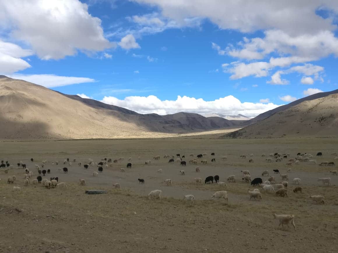
What Wildlife Can You Spot at More Plains?
Despite the barren appearance, More Plains and the surrounding area are home to some fascinating wildlife adapted to extreme altitude conditions. Keep your eyes open for:
Kiang (Tibetan Wild Ass): This is the most common large mammal you will see on More Plains. Herds of kiang graze on the sparse vegetation across the plateau. They are not shy and will often stand near the road, making for excellent photo opportunities.
Marmots: Himalayan marmots pop in and out of burrows across the plateau. You will spot them if you are quiet and patient.
Raptors: Golden eagles and lammergeiers (bearded vultures) patrol the skies above More Plains. Their wingspan against the blue sky is a photographer’s dream.
What Is the Complete Route Breakdown from Pang to Tanglang La via More Plains?
Understanding the distances helps you plan your driving time through this section.
Pang to More Plains start: Approximately 4 km uphill climb after Pang. The road is decent here.
More Plains stretch: About 35-40 km of flat, straight road across the plateau. This section takes about 30-45 minutes if you drive without stopping, but plan for an hour or more because you will stop for photos.
More Plains end to Tanglang La: After the plains end, the road begins climbing again towards Tanglang La Pass (17,480 ft / 5,328 m). This is a steep, winding ascent of about 25 km.
Tanglang La to Upshi: Post Tanglang La, you descend through Rumtse (the first village after a long stretch of nothingness) and reach Upshi, which is on the Leh-Manali Highway near the junction with the road to Chumathang and Tso Moriri. Upshi has dhabas, fuel, and a checkpost.
Upshi to Leh: About 47 km on a relatively good road, taking approximately 1.5 hours.
What Are the Key Photography Tips for More Plains?
More Plains is one of the most photographed sections of the Manali-Leh Highway, and for good reason. Here are some practical tips.
Golden hours matter: The morning light (before 9 AM) and late afternoon light (after 4 PM) create dramatic shadows across the plateau. The midday sun washes out the colors. If you are passing through in the morning (which most Sarchu-to-Leh travelers do), you are in luck.
Wide-angle lens: This landscape demands a wide-angle lens. A 16-35mm or equivalent will let you capture the full scale of the plateau with the road leading into the distance. Smartphone ultra-wide mode works well too.
Protect your gear: Sand and dust are constant companions on More Plains, especially when vehicles pass. Keep your lens cap on when not shooting and carry a microfiber cloth. If you are changing lenses, do it inside your vehicle with windows up.
Pull over safely: There is no designated parking on More Plains. Pull your vehicle completely off the road onto the shoulder before getting out. Army convoys pass through frequently, and they do not slow down.
Quick Practical Info: More Plains at a Glance
Altitude: ~4,800 meters / 15,750 ft
Length: Approximately 40 km along the highway
Location: Between Pang (15,400 ft) and Tanglang La (17,480 ft) on the Manali-Leh Highway
Season: June to September (highway opening dependent)
Nearest fuel: Tandi (before Pang, Manali side) or Karu (Leh side)
Nearest medical: Army camp at Pang (basic), SNM Hospital Leh (full facility)
Mobile network: None. Last coverage usually drops at Pang (BSNL postpaid may work intermittently)
Permits: No specific permit for More Plains. Standard Ladakh entry procedures apply
Best for: Photography, biking experience, self-drive road trips
Time needed: 45 min to 2 hours depending on stops
Lessons from More Plains
Embarking upon the Leh Ladakh road trip is a roller coaster ride of emotions. With spell-binding views that are hard to attain, once you experience them, everything stops. Important concerns are no longer valid, all fears are put to rest, life seems simpler, and you attain a sense of calm that stays with you.
I am a failure when it comes to meditation. However, I experienced something close to nirvana at More Plains. For me, spirituality is different from religion. Spirituality is an experience and emotion of being one with everything and yet being nothing in yourself. Such moments are rare, but these are the moments that build your grit and define your character.
With little to no vegetation and nothing material on your to-do list, this trip is a rare gem of truly being nature’s child. Going back to where you belong and claiming your true seat on nature’s table is something words simply cannot capture fully.
So, my friend, I know this has been a philosophical read. But More Plains does that to you. It turns practical road-trippers into temporary philosophers. If you are planning the Manali-Leh highway journey, keep this stretch in mind as the emotional highlight of your trip. And if you have already driven through More Plains, feel free to share your experience in the comments below. I would love to hear what it did to you. For the last leg of the journey to Leh, stay tuned for the next chapter 🙂
Also Read:
- The Complete Travel Guide for Manali-Leh Highway
- Baralacha La Pass, the Surreal Experience
- Jispa Village, the Complete Travel Guide
- Fuel Availability on the Manali-Leh Route
- How to Prevent AMS on Your Ladakh Trip
Last Updated: March 2026
Frequently Asked Questions
What is the altitude of More Plains on the Manali-Leh Highway?
More Plains (also known as Moore Plains) sits at an average altitude of approximately 4,800 meters (15,750 feet) above sea level. This makes it one of the highest flat plateaus you can drive across in India. The plateau is located between Pang (15,400 ft) and Tanglang La Pass (17,480 ft).
How long is the More Plains stretch?
The More Plains stretch extends for approximately 35-40 kilometers along the Manali-Leh Highway. On a clear road without stops, you can cross it in about 30-45 minutes. However, most travelers take 1-2 hours because the scenery compels you to stop multiple times for photos and to simply take in the view.
Is there any food or fuel available at More Plains?
No. There are no shops, fuel pumps, dhabas, or any services on More Plains itself. The nearest food and tent camps are at Pang (4 km before the plains start). The last reliable fuel pump on the Manali side is at Tandi (near Keylong). On the Leh side, fuel is available at Karu. Always carry extra water, snacks, and emergency supplies when driving through this section.
Can you camp at More Plains?
Technically yes, but it is not recommended for most travelers. The altitude of 15,750 ft makes overnight stays risky without proper acclimatization. Night temperatures drop well below freezing even in summer, and there is no water source or emergency help nearby. If you must camp, bring a 4-season tent and sleeping bags rated for -15C or lower. Most travelers prefer staying at Pang tent camps (Rs 500-1,000 per night) instead.
When is the best time to visit More Plains?
The best time is July to September, when the Manali-Leh Highway is fully operational and road conditions are at their best. September is particularly recommended for clear skies, fewer crowds, and excellent photography conditions. June is also good but some sections near Sarchu and Pang may still have snow patches early in the month.
Is there mobile network at More Plains?
No. There is no mobile network coverage on More Plains. BSNL postpaid may work intermittently at Pang, but connectivity is unreliable. The next reliable network coverage is at Upshi (Leh side) or Keylong (Manali side). Download offline maps before starting this section of the highway.
What wildlife can you see at More Plains?
The most commonly spotted animal is the kiang (Tibetan Wild Ass), which grazes in herds across the plateau. You may also see Himalayan marmots in their burrows and raptors like golden eagles and lammergeiers (bearded vultures) circling overhead. The wildlife here has adapted to extreme altitude and is not particularly shy of vehicles.