
The Ghost of Gata Loops is one of the most talked-about legends on the Manali-Leh Highway, a story about a truck helper who died here in October 1999 and is said to still ask passing travelers for water. The Gata Loops themselves are a series of 21 hairpin bends that climb from 4,190 m (13,750 ft) to 4,630 m (15,190 ft) in just 7 kilometers, sitting between Sarchu and Pang, roughly 76 km apart. So is the ghost real, or is it altitude sickness playing tricks on tired travelers at 15,000 ft? I will give you my honest take on both, plus everything you need to drive this stretch safely.
I first drove through the Gata Loops on a June morning in 2018, and I can tell you this. Nothing prepares you for the scale of what you see. The barren moonscape, the thin air, the silence broken only by your engine echoing off the canyon walls. And then there is that pile of plastic bottles at the 19th loop, which made zero sense to us until we heard the story behind it. Let me take you through the full experience.
Quick Info: Gata Loops are located between Sarchu (14,070 ft) and Pang (15,280 ft) on the Manali-Leh Highway. The 21 hairpin bends climb approximately 440 meters in 7 km. No fuel, food, or accommodation is available at the loops. The highway is open from mid-May/early June to October. Last updated: July 2026.
Let's quickly dive into the details:
What Are the Gata Loops on Manali-Leh Highway?
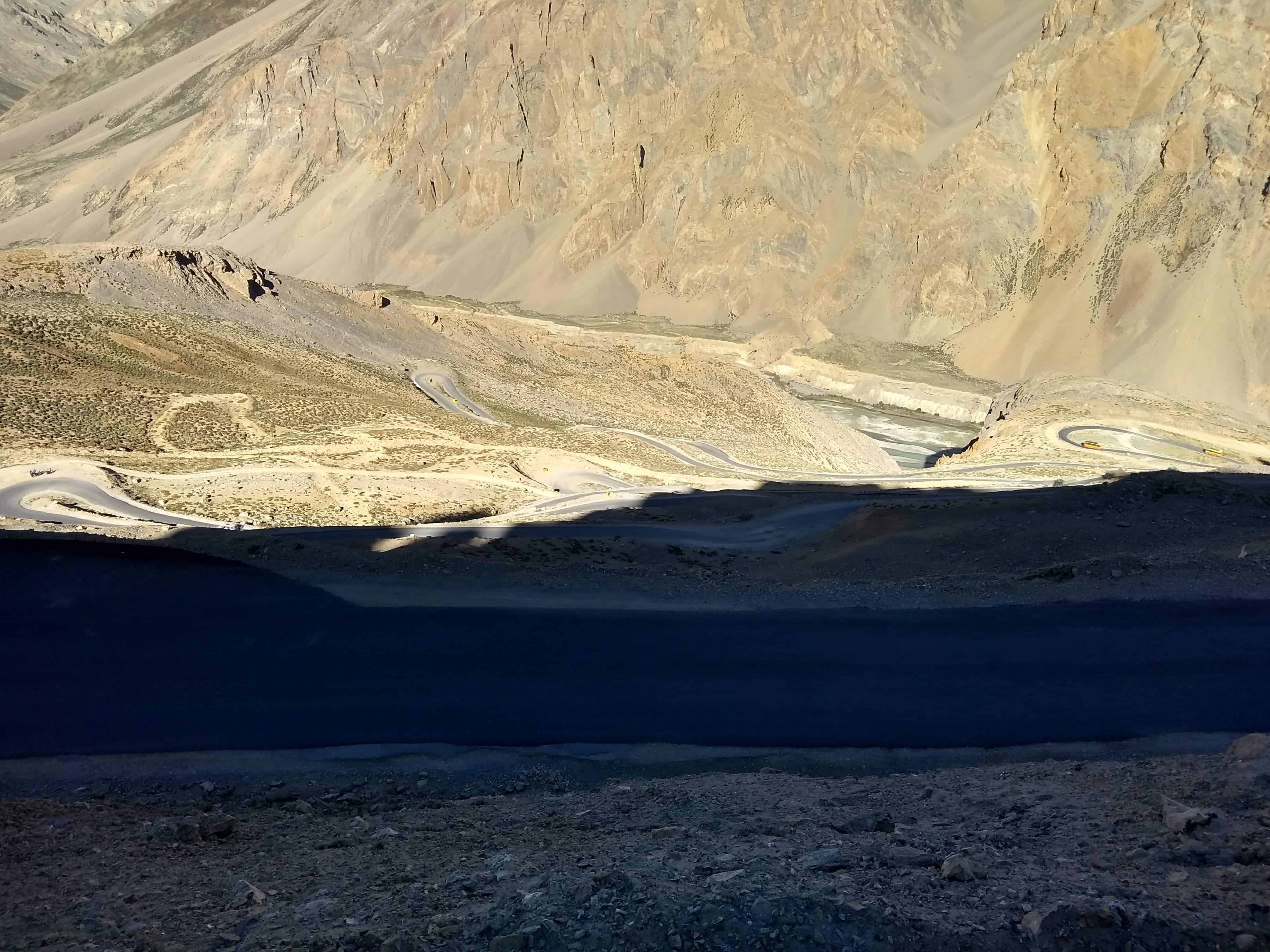
The Gata Loops are a series of 21 consecutive hairpin bends carved into the mountainside between Sarchu and Nakee La Pass (15,547 ft / 4,739 m). They are the steepest sustained climb on the entire Manali-Leh Highway, and they exist because the terrain here offers no gentle gradient. The road simply has to zigzag its way up a near-vertical slope to reach the pass.
Each loop is numbered with signage by the Border Roads Organisation (BRO), starting from Loop 1 at the bottom. As you gain altitude with every bend, the view behind you opens up dramatically. You can see the river valley below, the road you just drove, and the snow-capped peaks in the distance getting closer. By the time you reach Loop 15 or so, the air is noticeably thinner, and your body starts reminding you that you are well above 14,000 feet.
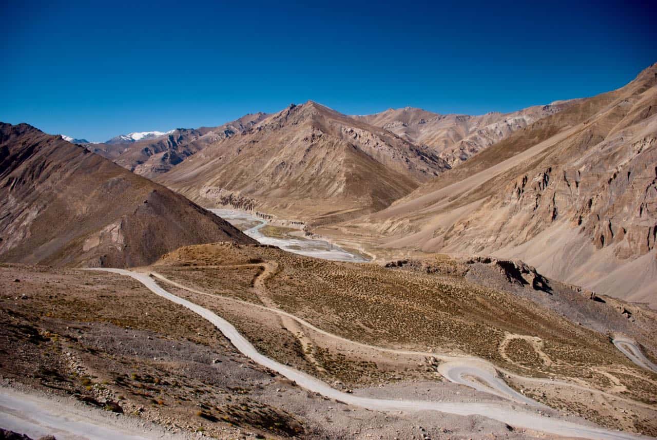
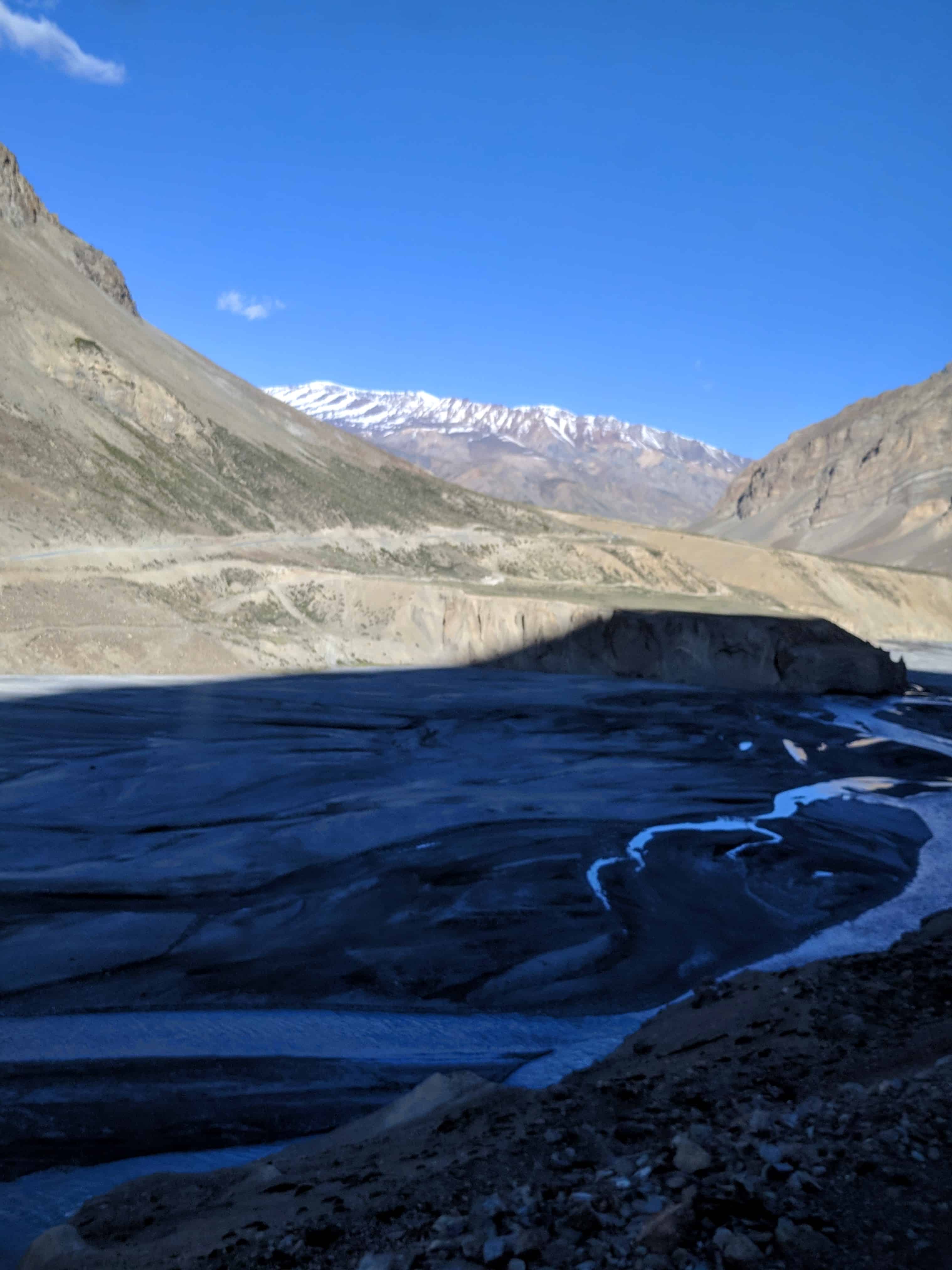
For context, the full Sarchu to Pang stretch is about 76 km and takes 2-3 hours depending on road conditions. The Gata Loops are the first major obstacle after leaving Sarchu. Once you clear them and cross Nakee La, you still have Lachulung La (16,616 ft) ahead before reaching Pang. Hence, keep in mind that the Gata Loops are just the beginning of a very demanding day of driving.
How Was the Drive from Sarchu to Gata Loops?
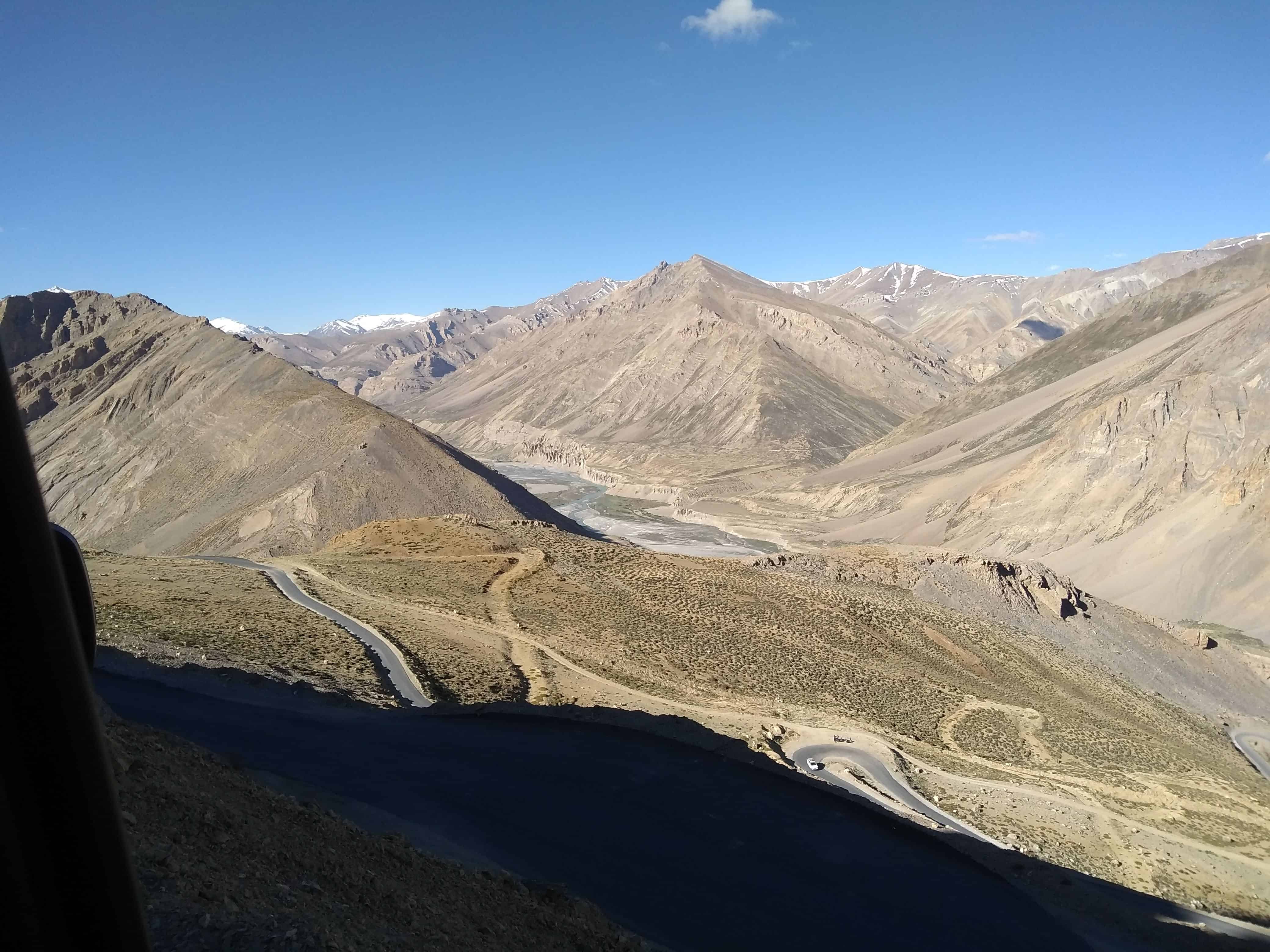
We started from Sarchu at 5 AM, which I strongly recommend. Early starts on the Manali-Leh Highway are not optional. They are survival strategy. The road between Sarchu and the Gata Loops runs along the riverbed for a while, and the morning light playing on the sand formations along the banks is genuinely mesmerizing. Centuries of river flow have sculpted these formations into shapes that look like they belong on another planet.
Right after leaving Sarchu, you cross the Himachal Pradesh checkpoint and then the Jammu and Kashmir (now Ladakh UT) checkpoint. Both require basic registration: number of travelers, vehicle number, origin, destination. This is standard protocol. It is not just bureaucracy. It helps authorities track travelers in case of emergencies, which happen more often than you would think on this route.
Now, here is where I have to be honest about our genius mistake. We forgot to fill our water bottles before leaving Sarchu. At 14,000+ feet, dehydration accelerates Acute Mountain Sickness (AMS), and water is literally your best defense. I am a walking, talking what-not-to-do list sometimes, and I take full ownership of that. So let me save you from repeating this. Fill your bottles. Carry at least 2 liters per person. There is no water source between Sarchu and Pang.

What Does It Feel Like Driving Through the 21 Hairpin Bends?
The loops start with signage indicating you have reached the legendary stretch. Our excitement was building, partly because of the views and partly because we had heard stories about this place. The panoramic view of sunlight playing games with the mountains was spectacular, and with each bend, our perspective shifted dramatically.
One bend after the next, as we gained elevation, the view of the river became clearer, and the snow-capped mountains in the distance seemed to sharpen into focus. We were taking it all in as fast as our brains could process it. In case you are wondering, yes, we stopped multiple times for photos. Multiple pit stops for selfies are a non-negotiable part of the Gata Loops experience 🙂
Physically, I started feeling lightheaded around bend 19. This is completely normal at 15,000+ feet, and it does not mean something is wrong. It means your body is working harder to compensate for the reduced oxygen. Right after the last bend, there is a vantage point where you can stop, rest, drink water, and look back at the loops you just climbed. I strongly recommend stopping here. Do not rush through this section.
Pro Tip: Drive slow through the Gata Loops. The combination of sharp turns, steep gradient, and thin air at 15,000 ft means your reaction time is already compromised. Bikes should stay in second gear. Cars should not exceed 20 km/h on the bends.
Who Is the Ghost of Gata Loops? The Real 1999 Story
The Ghost of Gata Loops is one of the most well-known legends on the Manali-Leh Highway. The story has been passed down through truck drivers, taxi operators, and the local community for over two decades now. Here is what we learned, and what research confirms about the legend.


The story dates back to October 1999. A truck driver and his helper (often referred to as “cleaner” in Indian trucking) were transporting goods to Leh. It was late October, and snowfall had already begun. The driver had been warned, but he had a deadline to meet, so turning back was not an option. This turned out to be one of the last trucks to cross Rohtang Pass before it closed for winter.
The truck made it all the way to the Gata Loops. But on one of the bends, the engine gave out. The truck came to a complete halt. With no traffic coming from either direction (Baralacha La had closed behind them, and Kunzum Pass was already shut weeks earlier), the driver decided to walk to the nearest settlement for help, leaving his helper behind to guard the cargo.

The snowfall continued for days, making it impossible for the driver to return. When he finally made it back with help, the helper was dead. Starvation, cold, thirst, and exposure had taken his life. He was buried near the spot where he died.
The Ghost Sightings
The following summer, when the highway reopened, travelers started reporting strange encounters at the Gata Loops. They described a man appearing from nowhere, waving at vehicles to stop, begging for water. Some who stopped and offered water claimed the bottle fell right through his hands. Others who ignored the figure reportedly fell severely ill with mountain sickness shortly after.
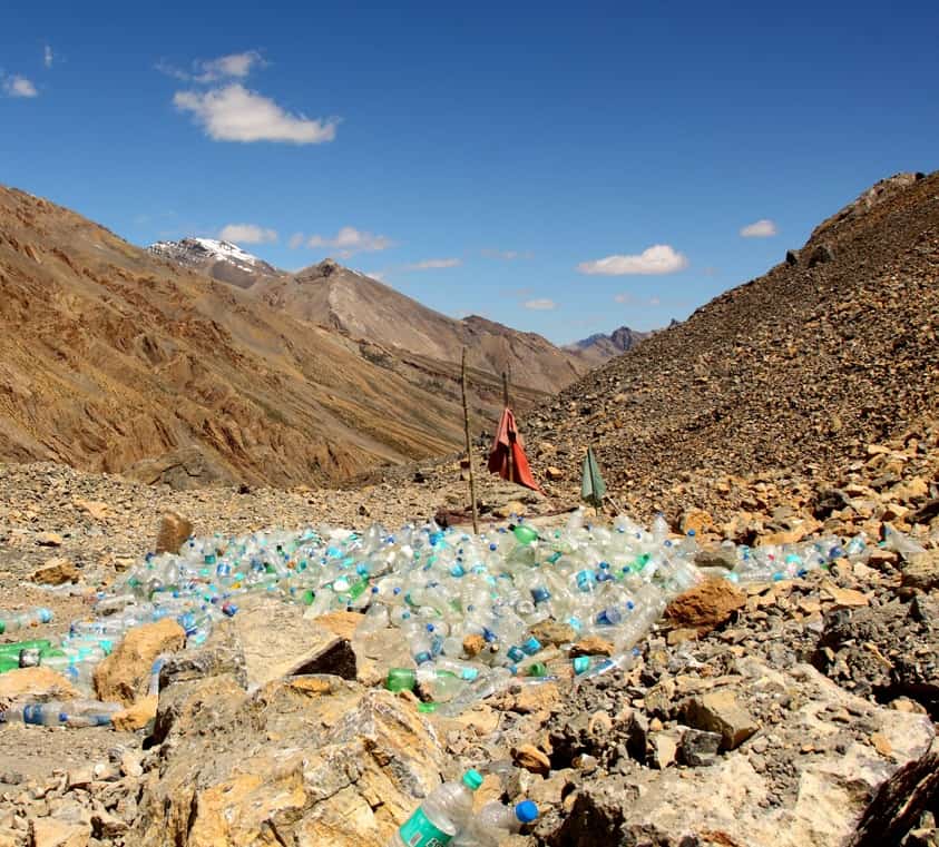
Over the years, the story grew. Bikers claim to have heard a plea for water echoing between the bends. Some truck drivers refuse to stop at the loops after dark. The locals eventually built a small stone structure, a shrine of sorts, at the 19th loop. Today, travelers leave water bottles, biscuits, and sometimes cigarettes as offerings. There is reportedly a human skull inside the stone structure, believed to be the helper’s remains.
Ghost legends aside, be prepared for other myths relating to Leh Ladakh that you will encounter during your trip.
Should You Leave Water Bottles at the Ghost Temple?
This is where I have a strong opinion, and I know not everyone will agree. The pile of plastic bottles at the shrine has become an environmental disaster. What started as a genuine tribute to a man who died of thirst has turned into a plastic dump in one of the most pristine landscapes in India.
I understand the gravitational pull of being on the safe side. Nobody wants to anger a ghost at 15,000 feet when they are already feeling lightheaded. But let us be honest. You are, in all likelihood, already experiencing some level of AMS at this altitude. The dizziness, the headache, the breathlessness. That is not a ghost’s curse. That is altitude sickness, and it happens to almost everyone who climbs rapidly from Sarchu (14,070 ft) to Nakee La (15,547 ft).
Instead of leaving plastic, here is what I suggest. If you want to pay respect, say a quiet prayer. Carry your water bottles with you. Be a responsible traveler and help keep the mountains clean. The DwD community has always believed that the best way to honor the mountains is to leave them better than we found them.
How to Drive Safely Through the Gata Loops in 2026?
Whether you are on a motorcycle or in a car, the Gata Loops demand respect. Here are the practical tips that will make this section safer and more enjoyable for you.
Start early from Sarchu. A 5 AM departure is ideal. The Gata Loops are best tackled in the morning when the air is calm and the sun is not yet harsh. By afternoon, strong crosswinds can make the exposed bends tricky, especially for motorcycles.
Carry enough water. At least 2 liters per person. There is no water source between Sarchu and Pang (76 km). Dehydration at high altitude is a fast track to severe AMS.
Drive in second gear (bikes) or low gear (cars). The gradient is steep, and you need torque, not speed. Do not exceed 20 km/h on the hairpin bends. Trucks and buses also navigate this stretch, and the road is not wide enough for aggressive overtaking.
Stop at the vantage point after Loop 21. There is a flat area at the top where you can rest, hydrate, and let your body catch up with the altitude gain. Do not rush. Take at least 15-20 minutes here.
Watch for symptoms of AMS. Headache, nausea, dizziness, and breathlessness are common at this altitude. If symptoms are mild, rest and hydrate. If someone in your group has severe symptoms (confusion, inability to walk straight, persistent vomiting), descend immediately. Do not push towards Pang. Go back to Sarchu and stabilize. For a detailed guide on prevention and treatment, check the complete AMS prevention guide.
Fuel up before leaving Manali. The last reliable petrol pump on the Manali side is at Tandi (32-35 km before Jispa). There is no fuel between Tandi and Karu (near Leh). If you are riding a motorcycle, carry extra fuel. The fuel availability guide for Ladakh has the complete list of petrol pumps on this route.
What Comes After the Gata Loops on the Highway?
Once you clear the Gata Loops, you cross Nakee La (15,547 ft), the third high-altitude pass on the Manali-Leh Highway. The terrain opens up into a more plateau-like landscape. Then comes Lachulung La (16,616 ft), which is the fourth pass and often considered the most painful. The road quality between Nakee La and Lachulung La can be rough, but BRO has been improving it year by year.
After Lachulung La, you descend to Pang and the More Plains, one of the most surreal stretches of road on the planet. Pang (15,280 ft) has basic tent accommodations and food, but do not expect much. It is a transit stop, not a destination. From Pang, the highway continues to Tanglang La (17,480 ft) before descending towards Leh.

Is There a Bypass Road That Skips the Gata Loops?
As of 2026, BRO has been working on alternate alignments and tunnel projects across the Manali-Leh Highway. The Shinku La Tunnel project (4.1 km long, twin-tube, estimated cost Rs 1,681 crore) is on the Darcha-Shinkula-Padum route under BRO’s Project Yojak, an entirely different highway connecting Manali to Leh via Zanskar. Major construction started in May 2025, and as of May 2026, tunnel boring is about halfway done, with completion targeted for August 2028. Once ready, it will bypass the 16,580 ft Shinkula Pass, cut around 60 km off the Manali to Leh distance, and keep 15 Zanskar villages connected through winter. This new route will offer an alternative to the traditional Manali-Leh Highway entirely, but it does not touch the Gata Loops at all.
However, there is no bypass road that specifically skips the Gata Loops on the traditional Manali-Leh route. If you are driving from Sarchu to Pang, you will go through all 21 loops. And honestly, my friend, I would not recommend skipping them even if you could. The Gata Loops are one of those experiences that define a Ladakh road trip. The challenge is part of the reward.
Where Should You Stay Before and After Gata Loops?
Your night halt options on either side of the Gata Loops are limited. Here is what works best.
Before the Gata Loops: Most travelers stay at Sarchu (14,070 ft) or, better yet, at Jispa (10,600 ft). I always recommend Jispa over Sarchu for first-timers because the lower altitude means significantly less AMS risk overnight. Sarchu has seasonal tent camps, set up only between June and September (Rs 1,500-3,500 per person including meals as of 2026, verify locally as rates change season to season). Jispa has proper guesthouses and hotels, starting from around Rs 1,500/night and going up to Rs 7,000/night for the better riverside properties.
After the Gata Loops: Most travelers push through to Pang (15,280 ft) or all the way to Leh. Pang has basic tent camps (Rs 1,000-2,000 per person with meals), but sleeping at 15,280 ft is brutal for those who are not acclimatized. If you stayed at Sarchu the previous night, your body has had some adjustment time. If you came straight from Manali or Keylong, Pang will be hard. For a full list of options, check the accommodation guide for Manali-Leh Highway.
What Common Mistakes Do Travelers Make at Gata Loops?
Having traveled this route and heard from hundreds of DwD community members, here are the most common mistakes people make at the Gata Loops.
Speeding through the bends. The temptation to “just get through them quickly” is strong, especially if you are feeling dizzy. But speeding on hairpin bends at 15,000 ft is a recipe for disaster. Slow and steady.
Not carrying water. I already told you about our mistake. Do not repeat it. This is not a suggestion. It is a survival tip.
Stopping too long at high altitude. While I said stop at the vantage point, I do not mean camp there for an hour. 15-20 minutes is enough. Extended exposure at 15,000+ ft without acclimatization accelerates AMS.
Leaving plastic at the shrine. As I mentioned, please do not add to the pile. The mountains deserve better, and the ghost (if you believe in such things) would probably prefer clean surroundings too.
Ignoring AMS symptoms. Some travelers tough it out and push towards Pang or Leh despite severe headaches, vomiting, or disorientation. This can be fatal. Always listen to your body. There is no shame in turning back. Your trip can wait. Your health cannot.
It is always best to plan your Manali-Leh Highway journey thoroughly and be prepared with all essentials. If you are planning your complete Ladakh itinerary, the most common Ladakh itinerary is a good starting point.
That is all on the Gata Loops, my friend. Whether you believe in the ghost or not, this stretch of road will give you a story worth telling. Drive safe, carry water, skip the plastic, and let the mountains do the rest. Feel free to join the conversation on keeping Ladakh clean. If you have any questions about the Manali-Leh Highway or need help planning your trip, drop them in the comments below or reach out to the DwD community. We are always happy to help 🙂
Last Updated: July 2026
Frequently Asked Questions
How many loops are there in the Gata Loops?
There are 21 hairpin bends (loops) in the Gata Loops section of the Manali-Leh Highway. They are numbered with signage by BRO. The stretch is approximately 7 km long and climbs from 4,190 m to 4,630 m altitude.
Is the Ghost of Gata Loops story true?
The origin story, a truck helper dying at the Gata Loops in October 1999, is widely believed to be true and is corroborated by locals and long-time truck drivers on the route. The ghost sightings that followed are folklore, passed down through the trucking and travel community. My honest take: the dizziness and disorientation many travelers report at the loops lines up closely with early AMS symptoms at 15,000 ft, not necessarily a haunting. Whether you believe in the supernatural part is up to you, but the shrine and water bottle pile at the 19th loop are very real.
What is the altitude of Gata Loops?
The Gata Loops start at approximately 4,190 m (13,750 ft) and end at approximately 4,630 m (15,190 ft). They lead to Nakee La Pass at 4,739 m (15,547 ft). The entire stretch is well above 13,000 ft, which is why AMS is a genuine concern here.
How long does it take to cross the Gata Loops?
The 21 hairpin bends take about 30-45 minutes to drive through at a safe speed. Motorcycles may take longer due to the steep gradient in lower gears. Add another 15-20 minutes if you stop at the vantage point at the top, which you should.

Is there any food or fuel available at Gata Loops?
No. There is no food, fuel, water, or accommodation at the Gata Loops. The last place to stock up before this stretch is Sarchu, and the next stop is Pang (76 km from Sarchu). Carry all supplies including water, snacks, and any medications you might need.
Can a car handle the Gata Loops?
Yes, all types of cars including sedans, SUVs, and hatchbacks can handle the Gata Loops. The road is paved (though quality varies year to year). The gradient is steep but manageable in low gear. SUVs have an advantage in terms of ground clearance, but sedans like Swift and i20 regularly make this climb. Stay in a lower gear and do not ride the brakes.
When is the best time to cross the Gata Loops?
The Manali-Leh Highway typically opens in mid-May to early June and closes by October. September offers the best road conditions at the Gata Loops as the monsoon has passed, BRO has repaired landslide damage, and the weather is stable. June-July can have snow patches on the upper loops. For real-time status updates, check the Manali-Leh Highway status page.