There have been few articles on Manali – Leh Highway published earlier on my blog. Now to make complete sense of all of them, I would like to put them all at one location to transform it into a Manali – Leh Highway Travel Guide along with the list of places to visit on Manali Leh Highway.
Download your FREE high-resolution version pdf copy of this Manali to Leh infographic guide. If, you liked it and found it helpful, please feel free to share it with your family and friends to help them too.
Let's quickly dive into the details:
What Makes the Manali – Leh Highway So Special?
The Manali – Leh Highway is easily the most adventurous as well as the most beautiful among all the Highways in India. Every adventure lover has a dream to travel on this 474 KM long Manali – Leh road trip at least once in his or her lifetime.
I strongly feel that everyone who loves to travel, be it adventure lover or a nature lover or any other form, must and must travel Manali – Leh Highway at least once in his/her lifetime. Personally, I am lucky enough to have traveled through the experience of this lifetime’s journey on Manali Leh road trip numerous times in the last fifteen years, as of 2026. And, I wish I will do it many more times in the future too.
The highway is desolate at many places, so it is better to plan the trip and have as much information as possible before making a trip to Ladakh.
I hope this detailed guide on Manali Leh road trip helps all my fellow travelers to find complete information or all they want to know about Manali – Leh Highway at a single place only. In this article, I have also merged the important places to visit on Manali Leh Highway road trip.
What Are the Quick Facts About Manali – Leh Highway?
| Detail | Information |
|---|---|
| Total Distance | 474 km (Manali to Leh) |
| Travel Time | 12-16 hours (single day) or 2 days (recommended) |
| Highest Pass | Tanglang La, 5,328 m (17,480 ft) |
| Total Passes | 5 (Rohtang, Baralacha La, Nakee La, Lachalung La, Tanglang La) |
| Road Open | Late May to early October (varies each year) |
| Maintained By | BRO (Project Deepak: Manali-Sarchu, Project Himank: Sarchu-Leh) |
| Petrol Pumps | Manali, Tandi, Keylong, Karu, Leh |
| ATM | Manali and Keylong (only ones on the route) |
| Best Months | June to September |
| Bypass via Atal Tunnel | Skips Rohtang Pass entirely, saves 3-4 hours |
| Last Updated | February 2026 |
Who Maintains the Manali to Leh Road?
The Manali – Leh Highway makes you experience the raw mother nature present on earth in almost its every form. Technically, BRO takes care of this Highway, and they have further divided its responsibility between Project Deepak and Project Himank. For the current 2026 opening status of each pass, refer to my Manali Leh Highway Status 2026 guide which I update regularly with BRO reports.
Project Deepak is responsible for maintaining the section from Manali to Sarchu (222 KM) in the Himachal Pradesh region while Project Himank is responsible for Sarchu to Leh (252.4 KMs) section which falls in the Union Territory of Ladakh.
How Do I Plan the Manali – Leh Highway Trip?
To help you plan a journey on Manali – Leh Highway, you can refer the below link which will explain you complete details about how you can plan your journey on Manali – Leh Highway.
The below link includes the information regarding best season to travel on Manali – Leh Highway, modes of travel on Manali – Leh Highway, bus services from Manali to Leh, public amenities like ATMs, Petrol Pumps, Liquor shops, etc. on Manali – Leh Highway. You can read all the details in the article How to plan a journey on Manali – Leh Highway.
Every year, I also publish an article to post updates on road conditions and Manali Leh Highway Status. You should be able to hook to that thread to get the latest updates on road closure, road opening, water crossings, etc.
2026 Update: With the Atal Tunnel (9.02 km long, opened in October 2020) now operational, travelers no longer need to cross Rohtang Pass on the highway. The tunnel connects the south portal near Manali directly to the north portal near Sissu in Lahaul Valley, saving 3-4 hours and bypassing the entire Rohtang Pass section. You still need a Rohtang Pass permit only if you want to visit Rohtang Pass specifically. For the Manali – Leh Highway journey, just drive through the Atal Tunnel.
Where Can I Stay on Manali – Leh Highway?
There are many options to stay on Manali Leh Highway. It is always better to know or have the list of all accommodation places on Manali – Leh Highway before you travel on it because, in such unpredictable terrain, you can never predict what can come to your rescue. So, having as many details as possible about the place is always favorable when making a Manali Leh road trip.
I have compiled the list of accommodation or stay options on Manali – Leh Highway at the below link which includes the information about their contacts, location, price range, experiences, etc. You can read the details in the article List of Accommodation Options on Manali – Leh Highway.
As of 2026, budget accommodation (dhabha tents and dormitory beds) ranges from Rs 200 to Rs 500 per night, while mid-range guest houses cost Rs 1,000 to Rs 2,500 per night at places like Keylong and Jispa. Keep in mind that prices tend to be higher during peak season (June and July).
Why Is Acclimatization So Important on Manali – Leh Highway?
Since you would be traveling above 14,000 feet for about 300+ KMs on Manali – Leh Highway, it is really IMPORTANT for you to understand about acclimatization, its importance, and AMS or mountain sickness. Many instances people have been found in doubt whether to take the babies or kids with them to Leh – Ladakh or on Manali – Leh Highway.
To answer your queries and doubts in such cases, I have compiled a brief text on the link below. The article includes information about AMS and acclimatization, which will help you keep your body better acclimatized. It will help minimize the chances of AMS or mountain sickness when it is safe to take babies or kids to Leh – Ladakh and what precautions to take, etc. You can read all the details in the article Acute Mountain Sickness and Importance of Acclimatization.
Pro Tip: I always suggest stopping overnight at Jispa over Sarchu when traveling from Manali to Leh. Jispa is at a lower altitude (3,320 m) than Sarchu (4,290 m), giving your body a much better chance to acclimatize. Many people who skip the Jispa halt and push to Sarchu end up suffering severe headaches and nausea at night.
What Should I Carry on Manali – Leh Highway?
I have tried to compile a practical list of things to carry while you travel or go on a trip to Manali Leh Highway. I am sure it will be helpful for you when you take this adventurous journey. You can refer to this complete list of things to carry when you go on Manali Leh road trip.
Clothes to Carry on Manali Leh Road
As for clothing to carry on Manali Leh road trip, it is always best to dress up in layers with Inner Thermals both lower and upper always ON. It might irritate in bright sunshine in lower hills, but as the altitude increases, then it will certainly help in the shades or evenings or mornings or if the weather turns dark. You need to carry heavy woolens when you travel to Manali – Leh Highway.
It is really IMPORTANT that you carry eateries like dry fruits (must have as a backup in case you get stuck), chocolates, some non-perishable food and ample water to keep each one of you hydrated.
You should always carry your water bottle and refill it as many times as you need water. It will not only keep you hydrated always, but you will also help in saving the Himalayas from plastic garbage. Remember, every tiny step counts and your step in this direction can help save the Himalayas too !! 🙂 🙂
Are You Making a Self-Drive Trip?
If you are traveling from Manali to Leh by car then you must carry a few things on this adventure trip to Ladakh.
Along with the list of things I mentioned in the above link, if you are self-driving on Manali Leh Highway, then you must take the Basic toolkit, screwdriver set, small hammer, puncture repair kit, iron rod, two or three “2 liters” empty bottles of Pepsi / Coke / Limca, etc. to carry extra petrol or diesel (jerry cans will leak, cold drink bottles do not leak), funnel, towing rope, spare tube (must for bikes), Elfy or Fevi quick (2-3 sachets), jump-start cables/wires, M-seal to prevent leakage, etc. These are among the things which I carried along on my trip to Ladakh.
You can also refer the top 40 list of things to carry on Manali Leh self drive trip.
Even if you are making a trip from Manali to Leh on bike, this list of things to carry will help you on your bike trip as well.
Also, do not forget to get your vehicle (car/bike) serviced about 2-3 weeks before the start of the Ladakh journey. This service will ensure that you have proper time in advance to test your serviced vehicle and get fixed any hitches that may have been introduced in that service.
What Are the Places to Visit on Manali – Leh Highway?
Throughout 474 KM, on the Manali – Leh Highway, one goes through varied forms of nature ranging from beautiful lush green valleys to rocky, barren multi-colored mountains to high walls of snow to violent river/water crossings (nallas) to wide flat lands to abrupt landslides to head swaying hairpin bends to butter-smooth roads to many non-existent and washed away roads to strong cold winds blowing you away and to what not. All this raises the fun of this ultimate journey to greater heights.
Video – Tourist Attractions on Manali to Leh Road Trip
In this travel guide of Manali Leh Highway, I am going to share an informatory dissection of all major places that come on the route from Manali to Leh along with the details of food, fuel, accommodation or stay options, amenities, etc.
I hope this information helps you get an idea of what you can expect on a journey of Manali – Leh Highway bearing in mind the stoppages of your interest including overnight stays, food, beverages, amenities, photos, etc.
If you are not interested in much of the text then you may also check the summary of the places in tabular format at the end of the article directly.
Altitude over Distance Graph
I have created this graph of Manali to Leh distance by the road along with the changes in altitude as you travel on Manali Leh Highway.
To save a bigger resolution picture of the altitude over distance graph of places on Manali Leh Highway, Right Click & then select the option: “Save Image As…”
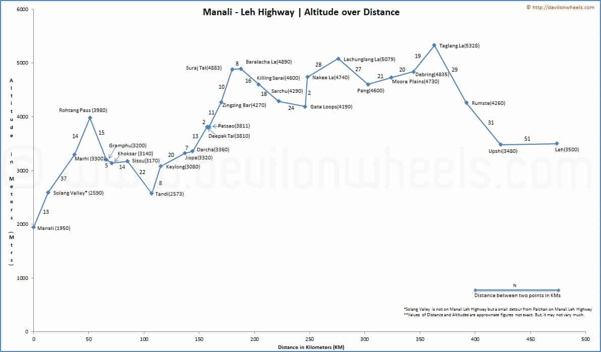
Manali | Altitude: 1,950 m (6,398 ft) and Solang Valley | Altitude: 2,590 m (8,497 ft)
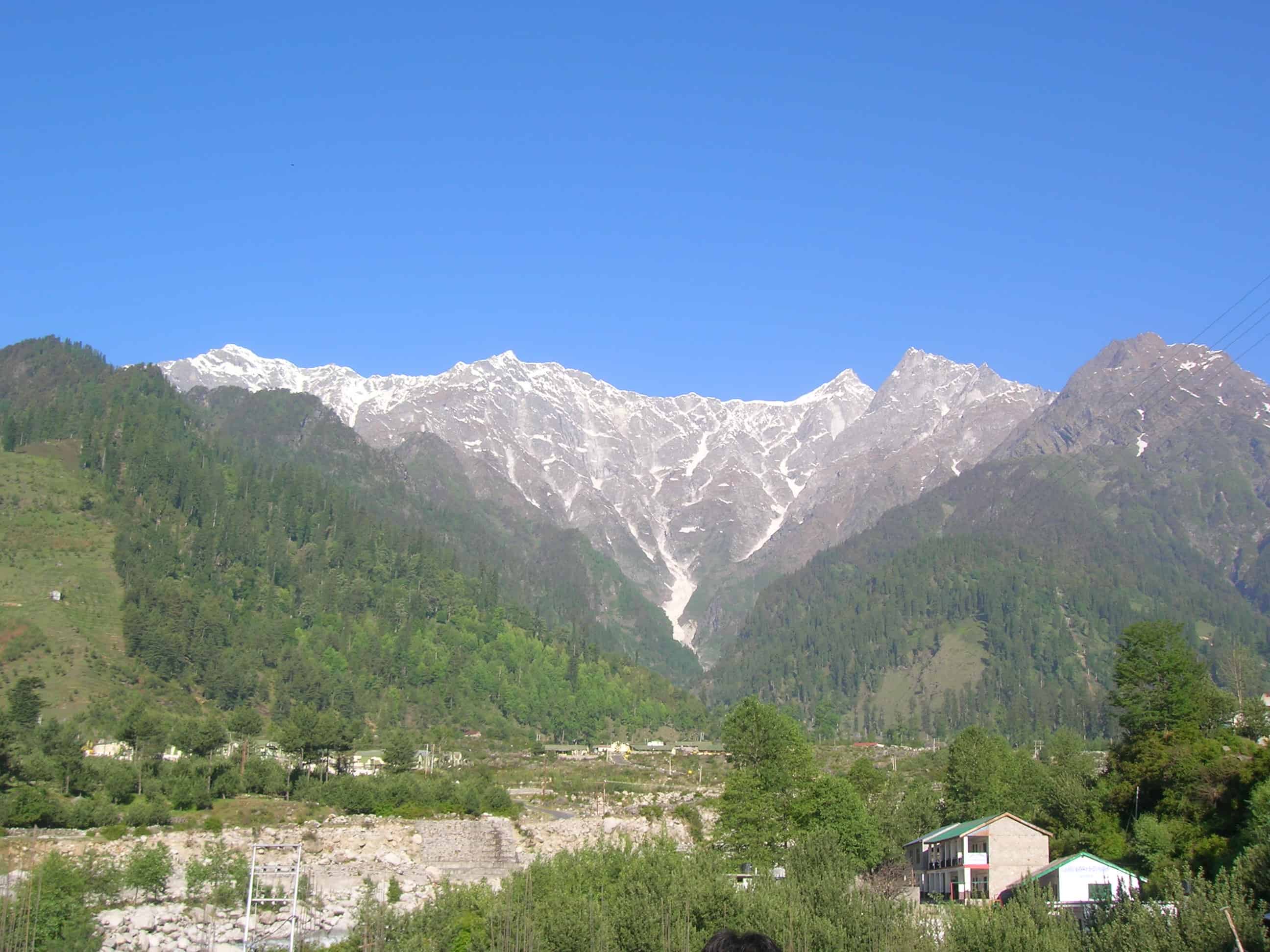
Manali, about 570 KM from Delhi, is the place from where this lifetime journey begins on Manali Leh Highway. Manali, the valley of gods is lush green at the time when you will be doing your Ladakh journey and you will definitely enjoy the weather up in Manali.
Although, in May – June due to the holiday rush, Manali is not a penny less than the chaotic trade fair, and I am sure you will not want to be at this place in such a tourist rush. You can do a lot in Manali town, and for comprehensive details including how to reach Manali from Delhi, I request you to read my Manali Travel Guide.
Should I Sleep at Manali or Solang Valley?
One point worth highlighting is that if you are traveling Leh – Ladakh from Manali side then you should avoid staying overnight in Manali town. Instead, stay overnight at Solang Valley, 14 KM away.
Why?
Manali is at a lower altitude than Solang Valley, and it does not help in acclimatization. Solang Valley does help acclimatize your body to some extent, which may help in minimizing the troubles of mountain sickness as you move ahead towards Leh Ladakh in the next few days of your Ladakh road trip.
Solang Valley is further 14 KM ahead of Manali and is a much calmer place as compared to Manali. Solang Valley also offers some majestic views along with adventure activities like parachuting, paragliding, skating, and zorbing, etc.
Is There Any Drawback to Stay at Solang Valley?
The only drawback sleeping at Solang Valley on your Ladakh road trip is that you won’t find as many options for a stay as you can find in Manali. The prices of the hotels in Solang Valley are likely to be on the higher side as compared to the varied economic hotel options available in Manali town. Also, the variety of cuisines will be much less as compared to what you get in Manali, and mostly, you will need to have your food in the hotel only.
But, the advantages of getting acclimatized and peace around will outweigh these minor hitches, unless you want a very cheap hotel. If you miss different cuisines and a lively crowded place, you can surely spend your day in Manali enjoying the other flavors of the valley and come back to the hotel at Solang Valley for night stay.
Is Solang Valley on Manali Leh Highway?
Technically, Solang Valley is not on Manali – Leh Highway. One needs to take a left diversion from Palchan and travel further 6 KM to reach Solang Valley.
If you have hired a taxi from Manali to Leh, you need to ask the driver upfront to pick you from Solang Valley hotel. If you have opted for a shared taxi / public bus, then you need to reach Palchan, the diversion point on Manali – Leh Highway to get into one of them en-route, but that also must have been booked in advance from Manali. Else, you will have to travel to Manali town in the morning to get the shared taxi.
Similarly, if you are traveling by Manali to Leh bus service, then as well, either make prior arrangements with the conductor the previous night or travel to Manali in the morning to catch the bus.
That was all about the first place that we covered of this Manali Leh Travel Guide 😉 …
Atal Tunnel (Rohtang Tunnel) | 2026 Update
Before I move to the places beyond Rohtang Pass, let me cover the biggest infrastructure change on the Manali – Leh Highway in recent years. The Atal Tunnel, a 9.02 km long horseshoe-shaped single tube tunnel, was inaugurated on 3rd October 2020. It connects the south portal at an altitude of 3,060 m near Dhundi (Manali side) to the north portal at 3,071 m near Teling (Sissu side) in Lahaul Valley.
This tunnel has completely changed the dynamics of traveling on Manali – Leh Highway. Earlier, you had to cross Rohtang Pass (3,980 m) which was the first major hurdle, with heavy traffic jams, slush, and a Rohtang Pass permit requirement. Now, the tunnel bypasses the pass entirely and brings you directly to the Lahaul Valley side in about 15-20 minutes.
Hence, if you are planning a Manali to Leh road trip in 2026, you will most likely be using the Atal Tunnel and not crossing Rohtang Pass. The sections of Gulaba, Marhi, Rani Nala, and Rohtang Pass described below are now relevant only for those who specifically want to visit Rohtang Pass as a tourist attraction (which requires a separate Rohtang Pass permit).


Keep in mind that you still need to cross the remaining four high passes (Baralacha La, Nakee La, Lachalung La, and Tanglang La) on the highway. The Atal Tunnel only eliminates Rohtang Pass from the equation.
Gulaba
Running through few small villages (Palchan, Kothi) of this beautiful lush green valley you reach Gulaba, 20 KM from Manali. Gulaba is famous as one of the lower winter snow points when the road to Rohtang Pass gets closed. There are only a few dhabhas at Gulaba and no options to stay. With the Atal Tunnel now in operation, most travelers bypass Gulaba entirely on their Manali to Leh journey.
Marhi | Altitude: 3,300 m (10,827 ft)
After Gulaba, you reach Marhi which is the highest snow point in winters when the road to Rohtang Pass is closed. There are few dhabhas at Marhi by HPTDC but there are no stay options.
Marhi is a common stoppage point for people doing cycling on Manali Leh Highway. Cyclists put up their own camps to spend the night at Marhi and get acclimatized for the ride ahead. Again, if you are using the Atal Tunnel, you will not pass through Marhi.
Rani Nala
Few KMs ahead of Marhi you reach Rani Nalla, which is a glacier point. This place is famous for its huge snow walls, more than 20 feet high. You can find snow here almost nine out of 12 months. The feeling of going between these huge walls of snow is impeccable, especially in the early season.
Of course, if you do not leave early in the day, then surely the traffic jam may frustrate you in the early season due to the narrow passage and kill your time. You need to leave as early as possible like 5 AM from Manali to avoid the traffic jam on Manali – Rohtang Pass road in June.
It is perhaps the last major point on the southern portal of Rohtang Pass. No stay or food options are available at Rani Nalla.
Rohtang Pass | Altitude: 3,980 m (13,058 ft)
51 KMs away from Manali town, Rohtang Pass connects the tribal valleys of Lahaul and Spiti to Kullu Valley. This is the hottest Himalayan tourist spot in Northern India and people flood this place in the month of May and June. Though there has been some respite since the introduction of Rohtang Pass permit.
Do expect heavy tourist rush and traffic jam, if you are late in leaving from Manali in the early season.
Rohtang Pass remains closed for more than six months in the winter months due to heavy snowfall and thus closing the Manali Leh Highway. However, with the Atal Tunnel now operational since 2020, the highway is accessible to Lahaul Valley even when Rohtang Pass is closed. The tunnel provides year-round connectivity to Keylong and the Lahaul Valley.
Many people feel the altitude factor after reaching Rohtang Pass with headaches and feeling to puke. So, it is better to keep yourself hydrated on the way. There is no place to stay or eat at Rohtang Pass.
Rohtang Pass is the first of the five major mountain passes in this travel guide of Manali Leh Highway.
Fun Fact: By the way, the meaning of Rohtang is “pile of corpses or dead bodies” 😉 …
Gramphu | Altitude: 3,200 m (10,499 ft)
After you descend towards the northern portal of Rohtang Pass, you reach a place called Gramphu. If you are using the Atal Tunnel, you will emerge near Sissu and skip Gramphu entirely.
At Gramphu, there is a diversion towards the right which will lead you to Spiti Valley via Kunzum Pass. If you want to visit Chandratal then you need to take the diversion towards Spiti and once you reach Batal, go straight towards Chandratal. There are no stay options at Gramphu, but you will find a couple of tea shacks / dhabhas serving tea.
If you are traveling from Kaza to Manali, it will be the first point where you will get mobile signals.
Khokhsar | Altitude: 3,140 m (10,302 ft)
Just a few KM after Gramphu, you will reach Khoksar which is the first settlement in the Lahaul Valley of Himachal Pradesh.
This place has several dhabhas where you can enjoy the food, a clean washroom or toilet to freshen up and a PWD rest house for night stay. To stay at the PWD rest house, generally, you will need bookings. There are few houses as well in this small village. The Chandra river flows through this place, and the surrounding views are just amazing from the village.
It is a major eating point on Manali Leh Highway especially when you are traveling from Manali to Jispa for the first night stop.
Sissu | Altitude: 3,170 m (10,400 ft)
Sissu or Khagling is a small town situated at the right bank of Chandra River in the Lahaul valley of Himachal Pradesh. There is a waterfall on the opposite side of town which looks spectacular especially near monsoon months.
Sissu has a PWD Rest House, but in case you want to stay, then you should book that in advance else you may not find the accommodation. My personal experience had not been good with getting any accommodation at any of the HP PWD Rest Houses.
Apart from PWD rest houses, there are a couple of more places to stay at Sissu including Hotel Triveni.
There are a few dhabhas or food stalls where you can find food, tea/coffee, and drinking water as well. You may also get some basic healthcare facilities at the local Primary Health Care center at Sissu town.
There is also a helipad that is used for the chopper services and mainly utilized by locals in the winter months when the roads are closed due to heavy snow at Rohtang Pass connecting Kullu – Manali valley and Kunzum Pass connecting Spiti Valley.
2026 Update: The northern portal of the Atal Tunnel (Rohtang Tunnel) is located near Teling, which is close to Sissu. So, if you are using the Atal Tunnel from Manali, Sissu will be your first major stop in the Lahaul Valley. This has made Sissu a much more popular halt than before.
Tandi | Altitude: 2,573 m (8,442 ft)
Next on the list of places to visit on Manali Leh Highway is the most important place called Tandi.
At Tandi, you will find the first petrol pump on Manali – Leh Highway after Manali. As of 2026, there are now three petrol pumps between Manali and Karu/Leh: Tandi, Keylong (operational since September 2021), and Karu near Leh. The next petrol pump after Keylong is about 350 KMs away towards Leh at Karu.
Hence, you must not miss the Tandi or Keylong petrol pump to top up the fuel. Apart from being famous for the petrol pump, Tandi offers a view of the confluence of Chandra River and Bhaga River. The merged river is called Chandrabhaga River, and when it enters Jammu and Kashmir, it is further called the Chenab river.
The Chandra River originates from Chandratal / Samudri Tapu, Spiti Valley, and Bhaga River originates from Suraj Tal or Surya Tal, Lahaul Valley. So, if you have time on hand then do click some pictures of the confluence too.
There is no Manali Leh Highway travel guide that is complete without the mention of Tandi petrol pump 🙂
Keylong | Altitude: 3,080 m (10,105 ft)
Next comes Keylong, which is the biggest town located on Manali – Leh Highway and is the district/administrative headquarter of Lahaul Valley and Spiti Valley districts of Himachal Pradesh.
All the major GOVT. Offices of the district are present in Keylong town only. The Keylong town used to be completely cut off from the outside world in the winter months of November to April, due to heavy snow present at Rohtang Pass. However, with the Atal Tunnel now operational since 2020, Keylong has year-round road connectivity to Manali and the rest of India.
2026 Update: A new petrol pump has been operational in Keylong since September 2021. This is a significant development for travelers on the Manali – Leh Highway, as earlier the gap between Tandi and Karu was over 365 KMs without fuel. Now with the Keylong petrol pump, you get one more chance to top up before the long desolate stretch ahead.
Keylong Sightseeing & Stay Options
There is a famous Kardang Monastery in Keylong, which is the largest and most important monastery of the Lahaul district of the Drukpa sect of Tibetan Buddhism. The views from the Keylong town are pretty nice with the Bhaga river flowing in between, but I felt it (Keylong) a bit boring 🙁 …
Also, people coming to explore Lahaul Valley sightseeing including Udaipur, Triloknath Temple, etc make Keylong as the base town.
Most people while traveling on Manali – Leh Highway, including the HRTC and HPTDC bus services, halt for a night stop at Keylong town. There are many options for accommodation (small hotels and guest houses) available at Keylong, including the famous HPTDC Hotel Chandrabhaga, Circuit House, PWD Rest House, Tourist Bungalow, etc. There are few small hotels or guest houses in Keylong town which are right on the Manali – Leh Highway and can be opted for a stay too without going down to Keylong village.
Utilities / Services at Keylong
There are phone services at Keylong, and mobile phone data services work great too at Keylong. You can make calls at home from Keylong as then mostly there will not be any phone signals once you cross Darcha and reach Upshi near Leh on Manali Leh Highway. As of 2026, Jio and Airtel both have decent coverage in Keylong.
The electricity power connections are also available at Keylong, which can be utilized to charge mobile or camera batteries.
Medical facilities are also available at the local hospital, and there is also one SBI ATM in Keylong town. So, if you have, by chance, missed the ATM at Manali to fetch the cash, then do not miss the ATM at Keylong. However, in the first place, I will say that DO NOT miss to carry cash from Manali ATM. Still, if you have missed it then try your luck at the Keylong ATM which is the only ATM available on Manali Leh Highway.
Jispa | Altitude: 3,320 m (10,892 ft)
Jispa is a small village that is located on the banks of the Bhaga River. While coming from Manali side, Jispa is my most preferred place for a night stay and to break the journey on Manali Leh Highway in two days. You can read more about my thoughts in the article why I suggest Jispa over Sarchu as a night halt.
The accommodation options present in Jispa are limited as compared to Keylong, but if you book them in advance, I bet the vistas are worth spending time and money. Jispa feels much closer to nature than Keylong.
There is a Hotel Ibex with a perfect restaurant serving delicious food. There are a couple of other guesthouses and some camping tents, including the Swiss tents, which are available as stay options at Jispa. You can get the food as well as beverages here in Jispa. For a detailed guide, check the complete Jispa travel guide.
The village also has a small monastery, a small museum along with numerous trails into the woods which you can explore. Or how about spending some time on the banks of Bhaga river? For me it is just amazing.
There is a helipad as well in Jispa, and it does have a telephone connection which you may use to call at home or inform someone close because beyond Jispa mobile signals (might have gone already) as well as fixed phones will be hard to find till you cross Upshi or reach Leh on this adventurous Manali to Leh road trip.
Darcha | Altitude: 3,360 m (11,024 ft)
Darcha is a small village that is considered as the last northernmost civilized place in Himachal Pradesh. Primarily, everyone traveling on Manali Leh Highway needs to stop at Darcha police checkpoint and has to register their names with vehicle number in the passerby records.
This acts as a record that a person has passed Darcha on his journey on Manali Leh Highway, which is useful in case of rescue like operations (or other purposes as well). Foreigners need to get their passports verified at Darcha police checkpoint.
Darcha is also the endpoint of a famous trek which starts from Padum, Zanskar Valley in the Ladakh region and of course, you can start the same trek from here as well. BRO completed the new road from Darcha to Padum via Shinku La pass. So, if you are planning a trip to Zanskar, then you can now drive from Darcha to Padum over Shinku La pass through this route.
Utilities, Food & Stay Options at Darcha
Food / Drinking Water / Beverages (tea/coffee) in dhabhas or roadside stalls is available at Darcha on Manali Leh Highway. This place also has some tented accommodations and a few people stay overnight at Darcha as well.
Darcha does have telephone and power connections, in case you need to call home or charge your phone or camera for one last time before reaching Leh, then you may try your luck here as well. I didn’t see any phone here, but people do say that the village has a phone connection.
Beyond Darcha
Beyond Darcha village, the vegetation will start to reduce, and the mountains will start to change their colors into dark brown watercolor paintings that we all used to paint in childhood. The decrease in vegetation also means difficulty in pumping the oxygen, and increasing altitude will make it even tougher.
This is another reason why you need your body to be better acclimatized and always hydrated on this tough journey on Manali Leh road. Do not forget to intake a good amount of water to keep your minerals and oxygen levels correct in the body.
Pro Tip: It will be best if you can carry ORS diluted water or Glucon-D water with you all the time and keep sipping it after every half an hour or so to keep yourself adequately hydrated on Manali Leh Highway.
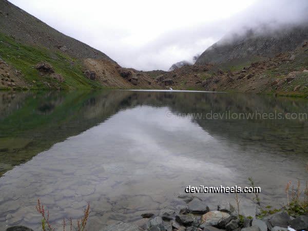
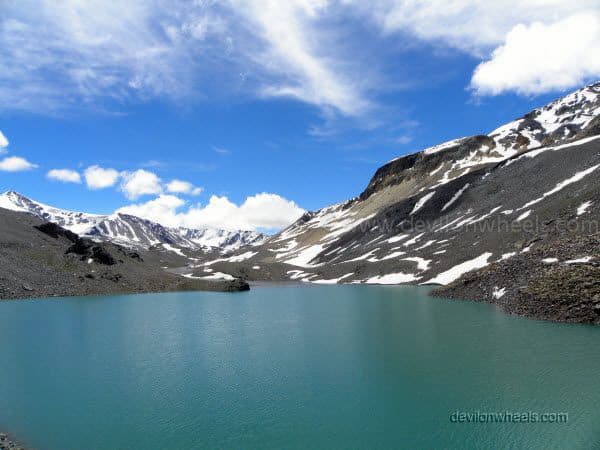
Deepak Tal | Altitude: 3,810 m (12,500 ft)
Next on the list of sightseeing places on Manali Leh Highway is Deepak Tal. It is a small man-made lake near Patseo having its own charm and is one of the two lakes that you can visit when traveling to Ladakh via Manali.
The still water of the lake offers some very nice reflecting views, almost picturesque from many different angles to all those photography lovers. So, if you are one of those, then get ready to shoot some unique angle of yours.
You can enjoy a cup of tea or your breakfast at the dhabha just beside Deepak Tal.
Fun Fact: Beyond Deepak Tal, you will be at an altitude of more than 14,000 feet till you reach about Upshi. So, get ready for some real fun in various ways… 🙂
Patseo | Altitude: 3,811 m (12,503 ft)
After passing through Deepak Tal, you will reach Patseo just a couple of KMs ahead. Patseo is a small place where only a few army camps are present, and sometimes they divert the road in some weird zigzag manner. Once you reach Patseo, the feeling of getting to the high altitude starts taking effect.
Zingzing Bar | Altitude: 4,270 m (14,009 ft)
Zing zing Bar is a tiny place with 2-3 tented dhabhas that offers stay options in them as dormitory beds. Of course, these dhabhas do offer food and beverages too.
If you leave early from Keylong/Jispa and you prefer to have your breakfast a bit late, then you can mark Zing zing Bar dhabhas for breakfast as well. This point is where the climb to the mighty Baralacha La pass starts.
Just after Zingzing bar, there used to be a nalla (water crossing) created by the melting snow of the Baralacha range. People mostly used to get stuck in it when traveling later in the day. However, BRO has built a permanent bridge on top of it, and the adventure of the most ferocious water crossings on Manali Leh Highway is gone.
Still, there are a couple of water crossings on Manali Leh Highway that become violent late in the noon. Hence, the advice of starting the day early on Manali Leh Highway still holds true 🙂 …
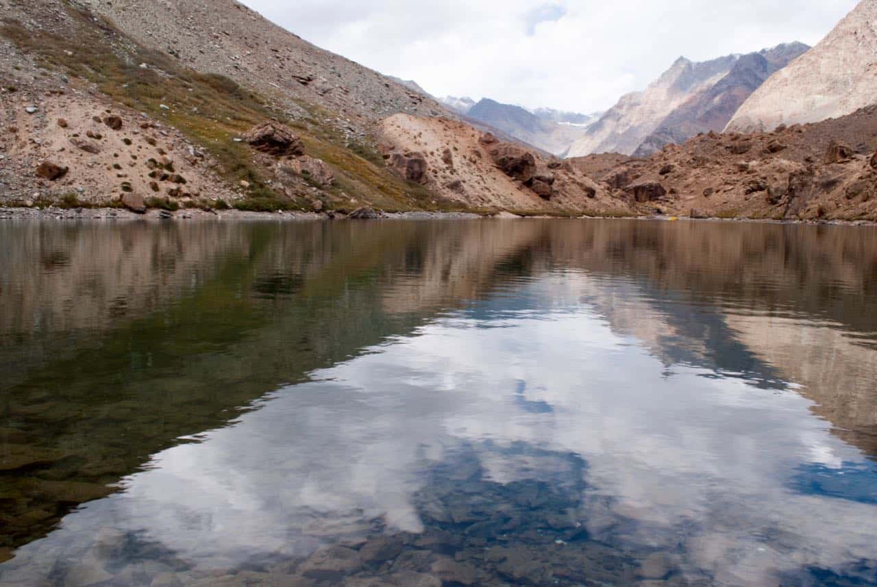
Suraj Tal | Altitude: 4,883 m (16,020 ft)
Suraj Tal or Surya Tal is the second-highest lake in India and 21st highest lake in the world. Amidst in the high hills of Baralacha La range and just below the Baralacha La pass (8 KMs before Baralacha La pass), you will find this beautiful crystal clear aqua colored sacred body of water. Suraj Tal is the source of the Bhaga river and remains frozen and cut off in the months of winter.
Early in the season, i.e., June, you will find this lake to be frozen as well. As we get more into the summers, having snow-covered peaks around and emitting its aqua green color at the foothills, the Suraj Tal lake looks simply stunning. Do not miss to click a few pictures of this amazing high altitude lake in India on Manali Leh Highway.
Later in the season time when the snow has melted, the Suraj Tal may not have much water in it and will not look as impressive as it looks in the early season.
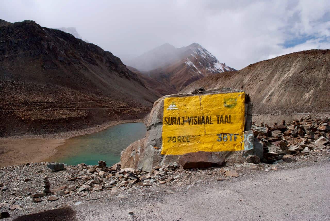
Baralacha La | Altitude: 4,890 m (16,040 ft)
Baralacha La or Baralacha Pass (La meaning Pass) is second of the five high mountain passes that come on the Manali to Leh Highway. Baralacha La connects the Lahaul district of Himachal Pradesh to the Union Territory of Ladakh.
![What is the best bike or best motorcycle for Leh Ladakh bike trip? [4 Things to Consider]](https://discoverwithdheeraj.com/yt_vid_thumbs/ladakh/81.png)
At the North-West base of the Baralacha La range, the Bhaga river originates from Suraj or Surya Tal, and at South East base, the Chandra river originates from Chandratal. Yunam river flows on the Sarchu (Ladakh) side of Baralacha La.
There is another famous trekking route which goes to Chandratal lake, either starting from or ending at Baralacha La. You will not find any food or water or accommodation at this pass.
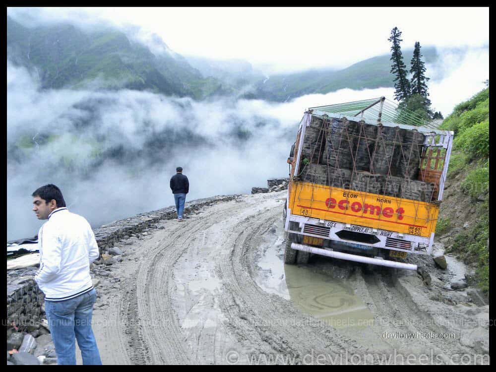
After Rohtang Pass, Baralacha Pass is the second major hurdle to cross or open. At least in the early season of this journey on Manali Leh Highway, you will certainly witness one or two vehicles either stuck aside or stuck in the middle which results in the traffic jams on this road.
The ice or snow melting from the slopes, battered by moving traffic either creates deep mud or deep water crossings by washing away the roads. This gushing water makes the journey more adventurous and full of challenges on this mighty mountain pass. Once you get into the late-season like September – October, the Baralacha La pass becomes mostly devoid of snow.
The feeling of passing through this particular pass is a feeling of its own kind and I purely loved it 🙂
Bharatpur – Killing Sarai or Sarchu Sarai | Altitude: 4,600 m (15,092 ft)
After passing through a small deserted place named Killing Sarai or Sarchu Sarai, you will reach Bharatpur, which has a few dhabhas to have some food as well as a series of tented accommodation running alongside the Manali – Leh Highway.
Some people do stay overnight at these camps as well, but being at much higher altitude than Sarchu, I do not recommend sleeping at Bharatpur. The accommodation or camps at Bharatpur are cheaper as compared to the stay options at Sarchu. You can have food/tea/coffee here.
Once you cross Bharatpur, after a few km, you will come across a road straight as an arrow leading towards Sarchu. Your instincts will compel you to rip apart, and just zip past through it, especially after you have been held up by the road conditions since morning.
I will STRONGLY suggest to hold on to those instincts of pushing the pedal of your vehicle as the road is straight, somewhat metalled. Still, it does have lots of bumps in between maybe due to the loose soil beneath or due to holes dug by Himalayan marmots. You do not want to get stuck in the middle of nowhere with a broken car at Sarchu.
All I want to say is that while speeding through that road to Sarchu on Manali Leh Highway, do not be too complacent else be ready for some super bumps on the way. When self-driving to Ladakh, always make sure you are not carried away by the emotions and drive with caution & care.
Sarchu | Altitude: 4,290 m (14,070 ft)
222 KM away from Manali, Sarchu is famous for the night halt because it offers some good tented accommodations on Manali – Leh Highway. At Sarchu, the region changes from Himachal Pradesh to the Union Territory of Ladakh. Also, the Deepak Project of BRO ends and Himank Project starts from Sarchu.
At Sarchu, there is a second police checkpoint where you need to register your name again on this epic journey on Manali Leh Highway. The entry acts as a record of your arrival up to Sarchu.
Sarchu is almost a middle point of the journey on Manali – Leh Highway offering some good accommodation options including the Swiss tents with attached toilets. Hence, many people do consider Sarchu for a night halt. People already having the night halt at Keylong or Jispa, usually stop for lunch at Sarchu. It does have a few dhabhas which offer food and beverages as well.
At Sarchu, you may get some fuel or petrol in black in dhabhas in case of any emergency.
Avoid Stay at Sarchu When Coming from Manali to Leh
Sarchu is at very high altitude and many people staying overnight at this rough place suffer from mountain sickness including sleepless nights, severe headaches or vomiting. No wonder many veterans call Sarchu a Vomit Hilton.
If you are not properly acclimatized, you will surely be one of them, suffering the pinch or punches, especially at night. While traveling from the Manali side, the body does not acclimatize properly, and in case you have not had a night stay at Keylong or Jispa, the body will surely suffer to adapt at such a high altitude of Sarchu at night.
Hence, even though Sarchu offers some good amount of stay options (tented) but it is always better to avoid a stay at Sarchu over Jispa or Keylong in the same order of preference. However, if you are coming from Leh or Tso Moriri lake after spending a few nights at higher altitudes in Ladakh, then your body is acclimatized already. So, in that case, you can opt to stay at Sarchu to break the journey on Manali Leh Highway evenly.
Gata Loops | Altitude: 4,190 m (13,747 ft)
After 24 KMs from Sarchu, a series of 21 hairpin bends or loops about 7 KMs long, just before Nakee La Pass, will elevate you from an altitude of 4,190 m to 4,630 m. These loops are famously called Gata Loops. No food, no fuel, and no accommodation options are available here.
Please note that there goes a story of a ghost of the Gata loops, please don’t pollute the environment in the name of the ghosts or superstitions and do not throw plastic bottles in the offering to them. Even if you are superstitious, offer the water and keep the bottle with yourself.
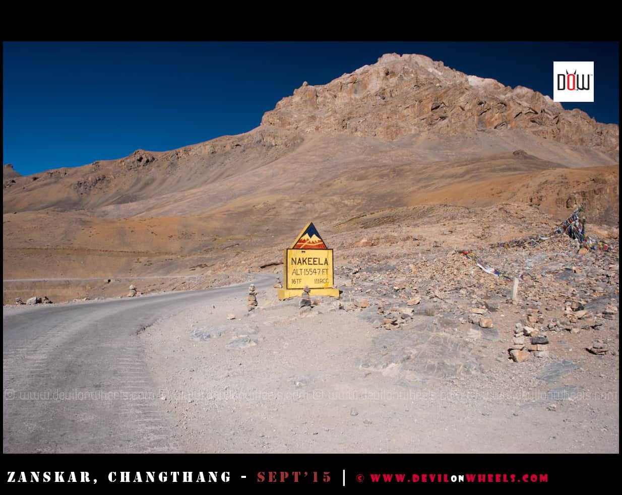
Nakee La | Altitude: 4,740 m (15,551 ft)
Next place on the list in this Manali Leh travel guide is the third of the five passes that come on the Manali – Leh Highway, Nakee La Pass. You will not find any soul, food, accommodation or fuel, or even trees here. The place is deserted.
There are few short cuts around Nakee La of dirt roads. I will strongly advise not to take any of the short cuts because I have seen many cars losing control especially when getting down and losing traction or burning brakes.
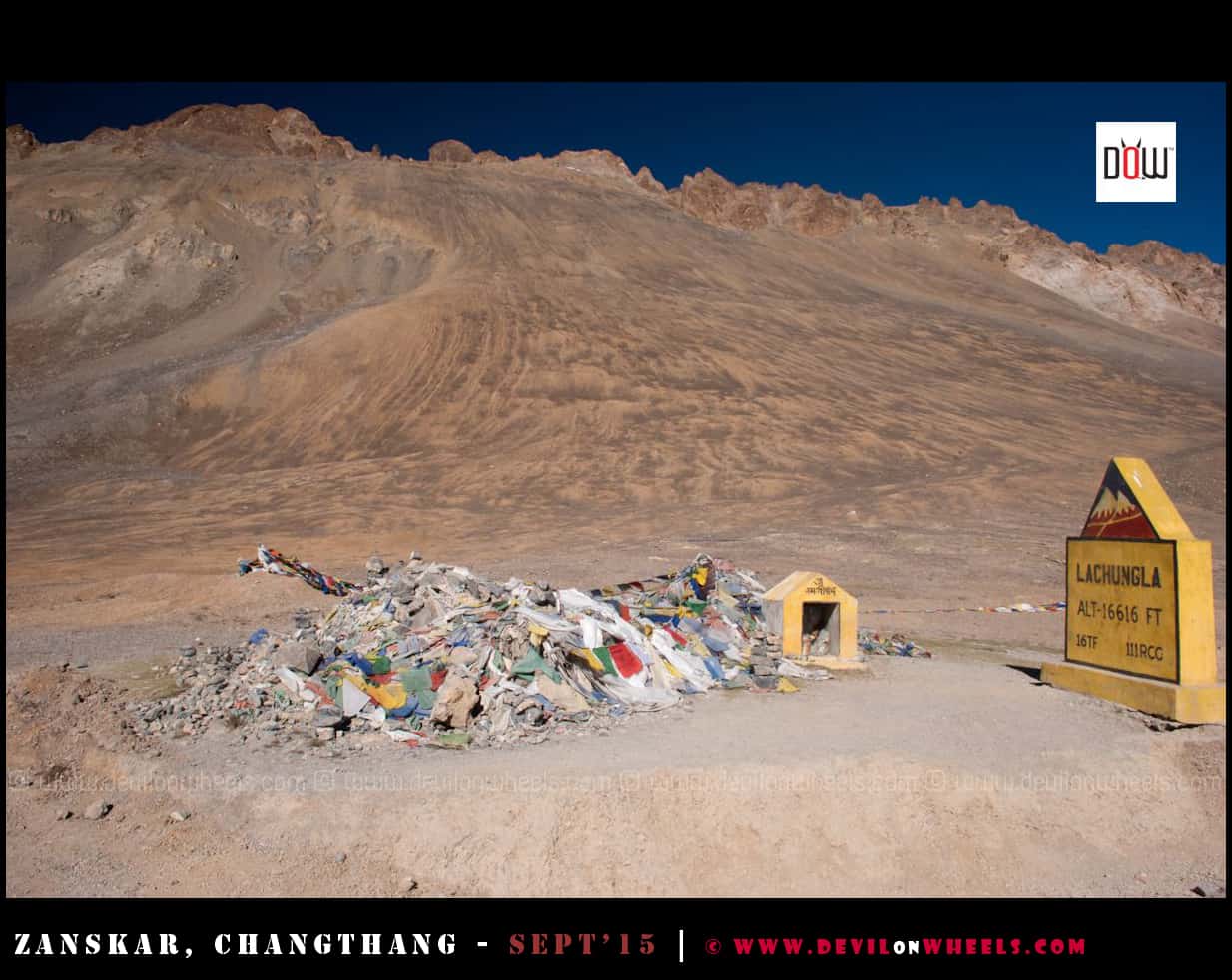
Lachalung La or Lachulung La | Altitude: 5,079 m (16,663 ft)
Lachulung La or Lachalung La or Lungalacha La is the second highest pass on the Manali – Leh Highway and fourth on the way from Manali to Leh road trip.
Get ready to start feeling some more breathlessness from here on. You will reach above an altitude of 5,000 m or 16,000 feet for the first time on your journey from Manali to Leh. Again there is no vegetation (also counts for breathlessness too), people, fuel, food, or accommodation at Lachulung La pass 🙂
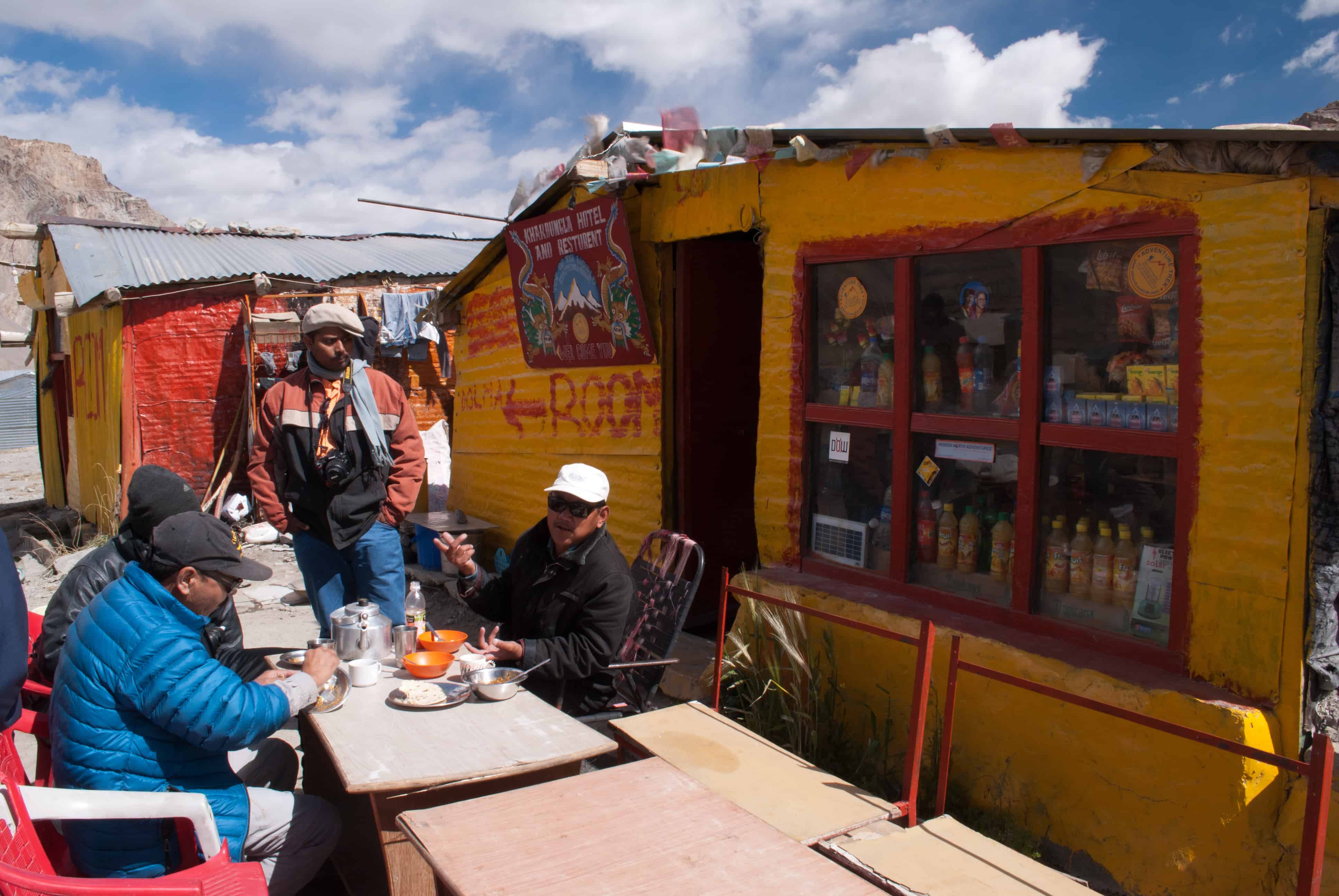
Pang | Altitude: 4,600 m (15,092 ft)
Pang is where you start to see those unique looking soil formations on the mountains. The special and deserted colors of Ladakh will become more prominent just around Pang and onwards. Pang also has the world’s highest transit camps.
At Pang, there are few tented accommodations in dhabhas for a night stay, and one can also enjoy food or beverages on their short stopover at Pang, evening tea maybe. One of the dhabhas also had an attached bathroom.
Few KMs before Pang, the road runs alongside a river which offers an exciting feeling and some very nice views. Pang, along with its surrounding areas, does offer some fantastic views to be captured in your camera. Hence, do not miss the opportunity to record a few of them and spend more time between Sarchu and Pang.
Pang is at a higher altitude than Sarchu, which will account for headaches and mountain sickness and offers much lesser accommodation options too. Hence, it is always better to stay at Sarchu, which offers Swiss tents too unless you have some emergency.
You may get some fuel or petrol in black in dhabhas at Pang in case of an emergency.
Pang is an important place where you can find food and accommodation at least before Rumtse – Upshi, which does have very basic and limited guesthouses.
If you are running late, then at Rumtse – Upshi as well you are likely to be unlucky on the accommodation front. Hence, if you think you have gone late and don’t want to carry on till Leh in the dark, I will suggest you stay at Pang only and thoroughly enjoy the rest of the colorful journey in the next day’s daylight. It will be worth it.
Some of the dhabha have electricity arranged from transit camps or battery backups, so, you may charge your phone or camera here. Also, the army transit camp may have a phone to call back home in case of an emergency.
In case of any medical emergency on Manali Leh Highway, you can get help at the Pang army transit camp.
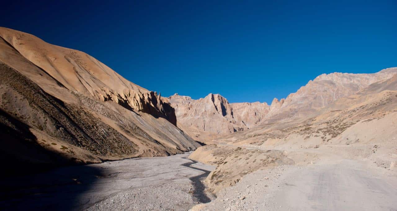
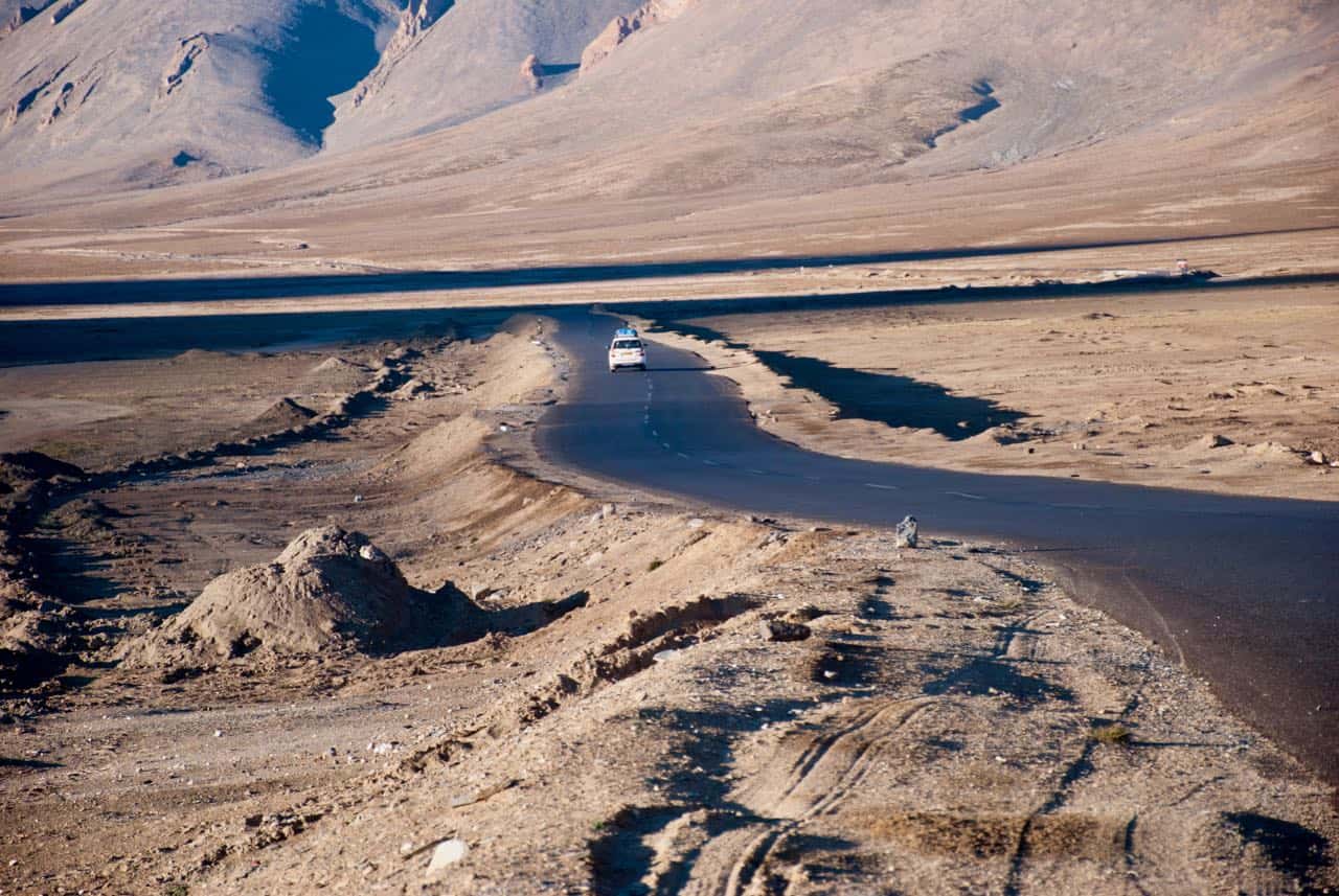
Moore Plains or More Plains or Morey Plains | Altitude: 4,730 m (15,518 ft)
Next place in this Manali Leh guide is one of the most interesting, popular by the names More Plains or Moore plains, or Morey plains.
More plains are surprising, flat bedded plains amidst the highest of hills in the country. They run over a length of about 30-35 KMs. As soon as one reaches Moore Plains, the instincts force people to make their own roads, but I request you not to do so because it damages the ecology of the place and disturbs the wildlife. So, please stay on that beautiful blacktop road.
Fortunately, BRO has built a well-laid tarmac road on which you may hit 60 KMPH for the first time after long hours of this drive on Manali Leh Highway. Hence, please avoid off-roading and preserve the ecosystem. Use this well-built road and enjoy the views at Moore Plains. You can make good progress on some lost time as well by staying on the road.
Many of the wild animals live on the water sources present in Moore plains and running the car off the roads may damage those scarce sources. Many people try to do off-roading for show off, and all sorts of things with their vehicles, including the race with other fellow drivers.
However, these jerks are unaware of the fact that along with risking the damage to the vehicle in loose soil or potholes in the middle of nowhere, they are also disturbing the ecology of the place.
So, I request at least you not to do so and respect mother nature in every term so that it prospers more and more for our generations to come.
If you are lucky, you may spot Kiangs (Ladakh wild asses) and Blue Sheep too at Moore Plains on Manali Leh Highway. Hence, keep your cameras ready for the game 🙂
Debring | Altitude: 4,835 m (15,863 ft)
At Debring, there are few wrecked shelters of road workers maybe and some army camps too. Sometimes there you can find a makeshift dhabha too where you can stop for tea.
Debring is the point where the diversion road to Tso Kar and Tso Moriri lakes connects at Leh Manali Highway. The road is a mix of good and bad to Tso Moriri from Debring.
However, you should not visit the Tso Moriri lake from Manali side as you will not have the inner line permits to visit the lakes. If you are traveling from Manali to Leh by car, even if you arrange the permits through a travel agent, it is not recommended that you attempt a stay at such high altitudes (Tso Moriri: 4,595 m and Tso Kar: 4,530 m) with improper acclimatization.
Well, on your return journey from Leh to Manali, if you have plans to visit Tso Moriri and Tso Kar lakes then you can exit on Manali Leh Highway at Debring via this route.
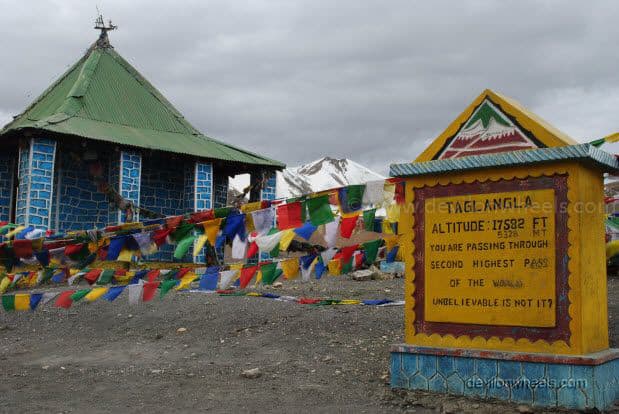
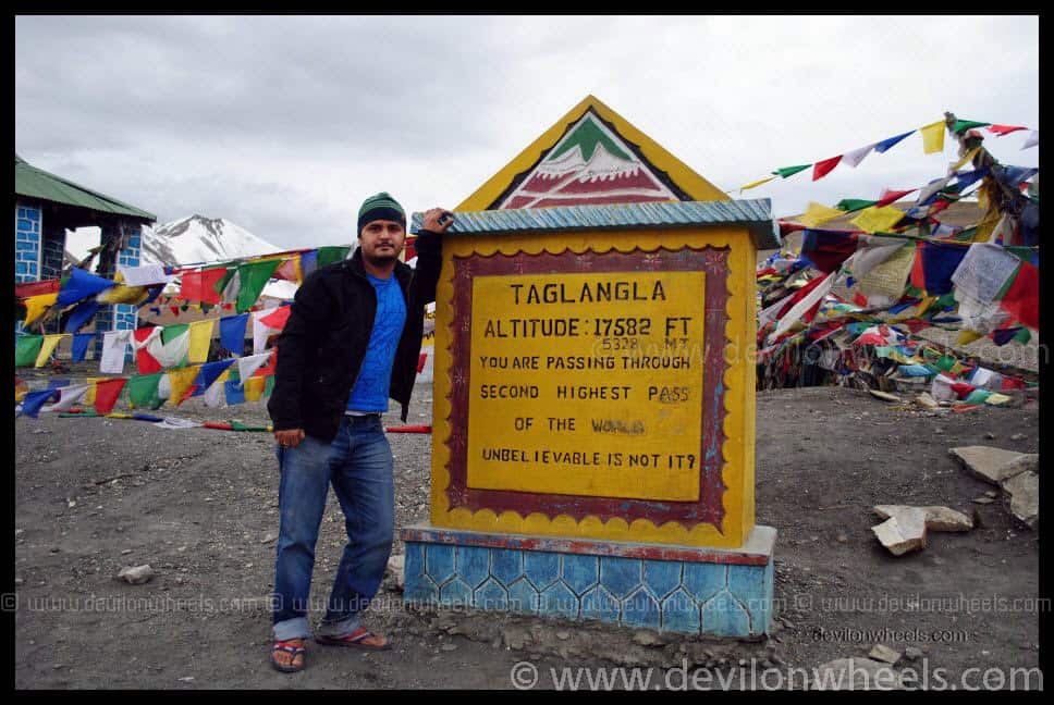
Taglang La or Tanglang La | Altitude: 5,328 m (17,480 ft)
Taglang La is the last and the highest mountain pass on Manali – Leh Highway at a whopping altitude of 5,328 m or 17,480 feet.
This pass is also the one falsely claimed to be the second-highest motorable pass or road in the world, after Khardung La (5,602 m or 18,380 feet) which is also falsely claimed as the highest motorable pass or road in the world.
The winds at the Tanglang La pass are cold, and the force is such that it will blow you off the cliffs. Sometimes, it is even hard to stand on your ground. Secondly, the oxygen level per breath decreases considerably, and with almost nil vegetation, most people suffer breathlessness at this pass.
The raging pollution from trucks or oil tankers also accounts for the stoppage being brief, by most people. Don’t be surprised if your head may also spin many rounds at this place, especially when you travel to Ladakh via Manali side.
I do not recommend spending more than 15 minutes on Taglang La pass. While our short stay of 10 minutes, I had almost lost my footing quite a number of times due to that spinning effect at Tanglang La 😀 (Disorientation or ataxia)…
The picture on the side of the signboard of one of the 15 highest motorable roads in the world, is a must for everyone visiting this Taglang La pass on Manali Leh Highway. You may not find food (sometimes a makeshift dhabha), and there is no place for accommodation at this place.
Rumtse | Altitude: 4,260 m (13,976 ft)
As you descend from Taglang La, Rumtse is the first settlement you will come across as you enter the Leh valley. It is situated alongside the Indus river and has some tea houses and homestays.
The road conditions are in good shape at Rumtse. From Pang to Leh, the road conditions are excellent, mostly on Manali Leh Highway. There will be a point when you are driving just beside the Indus river, and I tell you that you will feel ecstatic, forgetting all about the swaying headaches in the past 3-4 hours.
Reaching Rumtse, you will start to breathe a bit better, and so your head will also feel slightly lighter due to the decrease in altitude. I started to feel that I have reached my dream destination, i.e., Leh :).
I am not aware or heard of any accommodation or food options that may be available at Rumtse apart from some homestays if the villagers allow you to stay. Secondly, the drive to Leh from Rumtse is almost like driving in plains, and you can cover the remaining distance fast enough.
Hence, after clicking the pictures of this small village or spending time beside the Indus river, you better move ahead towards Leh and stay overnight.
Upshi | Altitude: 3,480 m (11,417 ft)
Upshi has the last police check-point where you need to register your name along with vehicle number in the records. This destination marks either your arrival in Leh town or marks the departure from Leh town in the opposite direction.
Upshi is a small village from where the right will take you to Hanle and Tso Moriri lake via Chumathang. It does have few homestays/guest houses with food but they are very basic.
A few KMs ahead of Upshi, at Karu, you will finally find the next petrol pump of Manali Leh Highway. You should top up at Karu petrol pump when traveling from Leh to Tso Moriri to Manali without going back to Leh. For more details on fuel availability, check my article on fuel availability in Leh Ladakh.
But, you can ignore it if you are heading to Leh, where you can find the fuel as well. So, overall you can ignore Upshi and Karu and head straight to Leh even if it gets late.
Leh | Altitude: 3,500 m (11,483 ft)
Leh, the dream of reaching Ladakh is finally true, and if you love this place then the excitement to reach Leh will refresh each of your body parts even after these 12 hours of an arduous journey on the Manali Leh Highway in a single day.
It is always better to spend a couple of nights at Leh for local Leh sightseeing and get a feel of the culture, people, traditions, monasteries and magical aura of Leh – Ladakh. It will also help you acclimatize to further sightseeing places in Ladakh.
Main market and Changspa road are two happening places in Leh. So, if you like a lively environment, then try to get a hotel in Leh as close to them as possible. The next day, along with local sightseeing, you can also arrange the Inner Line Permits for other Ladakh destinations you are planning to visit in Leh – Ladakh. For a detailed guide on accommodation options in Leh, check my article on cheap hotels in Leh Ladakh.
This completes the last place in this Manali Leh travel guide.
Frequently Asked Questions
Is the Manali – Leh Highway Open in 2026?
As of February 2026, the Manali – Leh Highway is closed for the winter. The highway typically opens between late May and early June every year, depending on the snow clearance by BRO. I suggest waiting at least 2-3 weeks after the official opening date before starting your journey, so that the road conditions stabilize. For real-time updates, keep an eye on my Manali Leh Highway Status article.
Can a Sedan or Hatchback Travel on Manali – Leh Highway?
Yes, a sedan or hatchback can travel on Manali – Leh Highway, but I would recommend an SUV or a vehicle with higher ground clearance. The highway has many rough patches, water crossings, and loose gravel sections, especially between Zingzing Bar and Pang. If you are taking a sedan, drive very cautiously, avoid the early season (June) when water crossings are at their worst, and make sure your car is in excellent mechanical condition. For more tips, read my self-drive tips for Leh Ladakh.
How Many Days Do I Need for Manali to Leh by Road?
I strongly recommend breaking the journey into 2 days with a night halt at Jispa or Keylong. While it is physically possible to cover Manali to Leh in a single day (12-16 hours), doing so means your body does not get time to acclimatize, and you risk severe AMS. Day 1: Manali to Jispa (137 km, 4-5 hours via Atal Tunnel). Day 2: Jispa to Leh (337 km, 10-12 hours). For a detailed itinerary, check how to plan a journey on Manali Leh Highway.

Where Should I Stop for the Night on Manali – Leh Highway?
My top recommendation is Jispa (3,320 m), followed by Keylong (3,080 m). Both are at relatively lower altitudes compared to Sarchu (4,290 m) and Pang (4,600 m), which makes them much safer for overnight stays from an acclimatization perspective. Avoid staying at Sarchu if you are coming from Manali side, as many people suffer mountain sickness there at night. Read more in my article on why Jispa is better than Sarchu.
Do I Need a Permit for Manali – Leh Highway?
Indian nationals do not need any special permit to travel on the Manali – Leh Highway itself. However, you will need Inner Line Permits (ILP) for visiting certain areas in Ladakh like Nubra Valley, Pangong Lake, and Tso Moriri. These permits can be obtained online or in Leh. If you plan to visit Rohtang Pass specifically (not via Atal Tunnel), you will need a Rohtang Pass permit.
How Much Fuel Should I Carry on Manali – Leh Highway?
After Manali, there are petrol pumps at Tandi (110 km from Manali) and Keylong (115 km from Manali, operational since 2021). The next fuel station is at Karu, about 350 km from Keylong. So, you must fill your tank completely at either Tandi or Keylong and carry at least 10-15 liters of extra fuel in cold drink bottles (not jerry cans, they leak). This is especially important for bikes with smaller tanks. As of 2026, petrol price in Himachal Pradesh is approximately Rs 95 per liter.
What Is the Best Month to Travel on Manali – Leh Highway?
The best months are July and September. In July, the road conditions are relatively stabilized after the initial opening rush, and the scenery is at its best with green valleys. September offers clear skies, stable weather, and the least crowd. June is doable but expect water crossings, slush, and traffic jams. October is risky as the highway starts closing anytime after the first week. For a month-by-month breakdown, read best time to travel to Ladakh.
Is There Mobile Network on Manali – Leh Highway?
Mobile network is available up to Keylong (Jio, Airtel, BSNL all work). After Keylong, you will lose signal near Darcha and will not get it back until Upshi or Leh. That is roughly a 300 km stretch with zero mobile connectivity. So, make all your calls and send updates to family before leaving Keylong or Jispa. For a detailed guide on which networks work where, check my article on mobile phone connectivity in Leh Ladakh.
Conclusion
I hope the above information in this Manali Leh road trip guide along with dedicated links will help you plan your travel to Manali – Leh Highway in the entirety and hassle-free.
In case you wish to share your experience or have any suggestions or have any questions then please feel free to leave a comment below, and I would be more than happy to respond to it within quick time. You can also join the DwD Community for more discussions with fellow travelers who have done this route 🙂 …
Have a travel question?? You can subscribe to my YouTube channel and leave a comment to ask your travel questions about traveling to the Himalayas.
If you know your friends or family are planning a trip to Manali Leh Highway, do share this travel guide with them to help them make a memorable Ladakh trip.
Last Updated: February 2026