")
If you have traveled through the mountains of North India, you know that the lakes here are not your regular weekend picnic spots. These are high-altitude, glacial, jaw-dropping bodies of water sitting at 14,000 to 17,000 feet, surrounded by barren peaks, thin air, and absolute silence. Over the years, I have been fortunate enough to visit some of the most stunning lakes in North India. Each one left a mark on me, and I still dream of taking a plunge into their icy cold waters someday.
In this article, I am going to walk you through 5 high-altitude lakes in North India that have captured my heart. For each lake, I will share practical details like how to reach, best time to visit, permits required, and what to expect. Whether you are planning a road trip through Ladakh, Zanskar, or Spiti Valley, these lakes should definitely be on your bucket list. So let us get started, my friend 🙂
What Makes High-Altitude Lakes in North India So Special?
High-altitude lakes in North India sit above 4,000 meters (13,000 feet), fed by glacial meltwater and snowfields. The colors you see are not Photoshop tricks. The deep blues, turquoise greens, and mirror-like reflections come from mineral content, depth, and the angle of sunlight at these elevations. Most of these lakes are accessible only during summer months (June to September), and visiting them requires careful planning around road conditions, permits, and acclimatization.
Here are my top 5 picks, based on personal experience and years of traveling through the Indian Himalayas.
1. How Do You Reach Tso Moriri Lake in Ladakh?
Tso Moriri in the Changthang region of Ladakh is, in my opinion, the most beautiful high-altitude lake in India. It is also the largest lake in India that sits entirely within Indian territory at an altitude of 4,522 meters (14,836 feet). The lake stretches about 19 km in length and 7 km at its widest point. It is a designated Ramsar Wetland Site, which tells you about the ecological importance of this place.

The first time I saw Tso Moriri, I felt a deep sense of calm that is hard to describe. The water was an impossible shade of blue, the mountains around it were dusted with snow, and the silence was so complete that you could hear your own heartbeat. I spotted Kiangs (Tibetan wild ass) grazing near the shore and a few Bar-headed Geese on the water. This is a place that makes you feel genuinely small and grateful at the same time.
How to Reach Tso Moriri
Tso Moriri is about 220 km from Leh, and the drive takes around 7-8 hours via Chumathang. You can also reach from the Manali side, though I would strongly advise against approaching from Manali for first-timers because of extreme altitude gain in a short time. The standard route from Leh goes through Upshi, Chumathang (where you can stop at the hot springs), and then onward to Korzok village on the lake’s western shore.
Permits and Practical Info
You need an Inner Line Permit (ILP) to visit Tso Moriri. As of 2026, the Ladakh EDF (Environment Development Fee) is Rs 400 per person plus Rs 20 per person per day plus Rs 10 Red Cross per day. The ILP can be applied online through the Ladakh UT portal. Keep in mind that there is no ATM, no fuel pump, and very limited mobile connectivity at Korzok. BSNL postpaid works intermittently. Carry enough cash, fuel, and supplies from Leh. Homestays at Korzok cost around Rs 1,000 to Rs 1,500 per night including meals.
Best time to visit: June to September. The road typically opens by late May and closes by early October.
2. Why Is Pangong Tso the Most Famous Lake in Ladakh?
Pangong Tso needs no introduction. Ever since the Bollywood film “3 Idiots” featured its final scene here, this lake has become the most sought-after destination in Ladakh. But trust me, no movie can do justice to seeing Pangong in person. This saltwater lake stretches over 134 km, with about 60% extending into Tibet (China). At 14,270 feet (4,350 meters), the lake changes color throughout the day, shifting from deep blue to turquoise to almost green depending on sunlight and cloud cover.
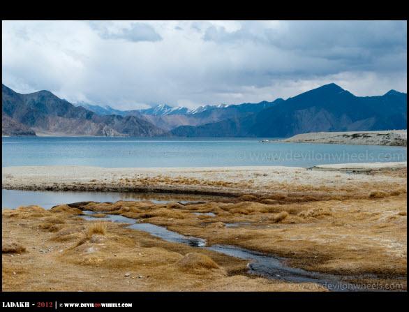
What hit me the most about Pangong was the sheer scale of it. Standing at the shore, you feel like you are looking at an ocean, not a lake. The water was so clear near the edges that you could see the pebbles at the bottom. The landscape around is completely barren, brown mountains meeting blue water, and the silence is broken only by the wind. During winter, the entire lake freezes solid, which is a sight in itself if you happen to visit Ladakh in January or February.
How to Reach Pangong Tso
Pangong Tso is about 160 km from Leh, a 5-6 hour drive via Chang La (17,585 feet). You can also reach directly from Nubra Valley via the Shyok route, which is about 160 km from Diskit and takes 5-7 hours. There is now a petrol pump at Tangste (IndianOil, opened 2023), about 34 km before Pangong, but I would still recommend carrying extra fuel from Leh just to be safe.


Permits and Practical Info
ILP is required. Same process as Tso Moriri, apply online through the Ladakh UT portal. Accommodation near Pangong ranges from tent camps (Rs 2,000 to Rs 4,000 per night) to basic guesthouses. Mobile connectivity has improved significantly. Jio and Airtel 4G now work at the lake, though BSNL remains the most reliable network across Ladakh. There is also a public bus service from Leh to Pangong if you want to go budget.
Best time to visit: June to September for the iconic blue colors. January to February for the frozen lake experience.
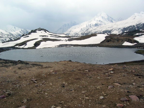
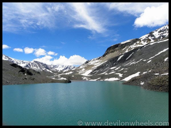
3. Where Are the Stat Tso and Lang Tso Twin Lakes Near Penzi La?
This is a lake (well, two lakes) that most people miss because they are too focused on reaching Padum in Zanskar Valley. Located right near Penzi La pass at an altitude of about 14,400 feet (4,400 meters), the highest point on the Kargil to Zanskar road, the twin lakes of Stat Tso and Lang Tso sit barely 200 meters apart. They are smaller than Pangong or Tso Moriri, but what they lack in size, they make up for with reflections that will leave you speechless.
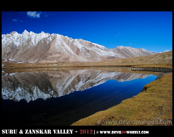
When I visited these twin lakes during autumn, the snow-capped mountains were reflected so perfectly in the still water that it was hard to tell where the mountains ended and the lake began. I will be honest, I did not dare to jump in. The cold at that altitude was biting, and the wind chill made it feel much worse. But the dream is still alive, and I plan to take that plunge someday 🙂
How to Reach Stat Tso and Lang Tso
The twin lakes sit right on the Kargil to Padum road at Penzi La. If you are driving from Kargil, Penzi La is about 130 km away and takes around 7-8 hours given the road conditions. From the Zanskar side (Padum), it is about 100 km. There is no separate detour required, you literally drive past them. Just make sure you stop and spend some time here instead of rushing through.
Practical Info
No separate permit is needed for Indian nationals to visit Zanskar Valley or Penzi La. However, keep in mind that the road from Kargil to Padum opens typically by mid-June and closes by early November. There is no accommodation, no food stall, and no mobile network at Penzi La. The nearest town is Rangdum, about 20 km towards the Kargil side, where you can find basic guesthouses. For a detailed Zanskar trip plan, check my 9-day Zanskar Valley itinerary from Leh.
Best time to visit: Mid-June to September, when the Kargil-Padum road is open.
4. What Is So Special About Chandratal Lake in Spiti Valley?
Chandratal Lake (Moon Lake) in Spiti Valley sits at an altitude of 4,300 meters (14,100 feet) and has a circumference of about 2.5 km. It is believed to be one of the sources of the Chandra River. Chandratal is a Ramsar Wetland Site and is one of the most accessible high-altitude lakes in India, which makes it hugely popular among trekkers and road trippers alike.
I have a confession to make. Despite multiple trips to Spiti Valley, I missed Chandratal by barely half a kilometer once due to bad weather. That was years ago, and I have since made it a point to visit. The colors of this lake are genuinely surreal, deep emerald green in the center fading to lighter shades near the edges, with the barren, treeless Spiti landscape forming a stark backdrop. It is the kind of place where you sit down, go quiet, and just stare for a long time.
How to Reach Chandratal
There are two approaches. From Manali, you cross the Atal Tunnel (no Rohtang Pass permit needed) and drive via Gramphu to Batal. From Batal, it is about 14 km to the lake, which can be driven up to a parking area 2.5 km from the lake, followed by a short trek. The second approach is from Kaza via Kunzum La. The HRTC bus from Manali to Kaza (fare Rs 400-570) now goes via Atal Tunnel. For a budget trip to Chandratal, public transport is a viable option with some planning.
Permits and Practical Info
As of 2026, the entry fee for Chandratal is Rs 150 for Indian nationals and Rs 500 for foreigners. An e-permit (free) is required via the eaagman.hp.gov.in portal. Camping at the lake banks is banned by the Koksar Panchayat. Authorized camps are located 3-5 km away from the lake and cost Rs 1,200 to Rs 2,500 per night including meals. There is no mobile network at Chandratal or Batal. The nearest connectivity is at Gramphu or beyond. For a detailed itinerary, check my Chandratal Lake 5-day itinerary.
Best time to visit: Mid-June to early October. The lake area gets snow as early as late September in some years.
5. How High Is Suraj Tal Lake on the Manali-Leh Highway?
Suraj Tal (Lake of the Sun God) sits at a staggering altitude of 4,950 meters (16,240 feet), just below Baralacha La pass on the Manali to Leh Highway. It is the third-highest lake in India and 21st highest in the world. The glacial meltwater from the surrounding peaks feeds this lake, which in turn feeds the Bhaga River, a tributary of the Chenab (and ultimately the Indus River system).
What strikes you about Suraj Tal is the raw, untouched beauty. There are no stalls, no crowds, no hotels. Just thin air, cold wind, and a still sheet of turquoise water framed by brown and black mountains with patches of snow. Every time I have driven past on the Manali-Leh Highway, I have stopped here. The aqua blue color of the water against that harsh, barren landscape is one of the most visually stunning things I have seen in the Himalayas. The dream of taking a dip here is very much alive, though at 16,000+ feet, it would take some serious preparation and courage 🙂

How to Reach Suraj Tal
Suraj Tal is located right on the Manali-Leh Highway, about 65 km north of Jispa (the recommended overnight stop, read why I suggest Jispa over Sarchu). Coming from Manali, you will cross the Atal Tunnel, pass through Keylong and Jispa, climb up through Darcha, and reach Baralacha La pass where Suraj Tal sits just below the pass on the eastern side. No detour needed, you drive right past it.
Practical Info
No permit is needed to visit Suraj Tal. It is on a public highway. However, keep in mind that the Manali-Leh Highway is typically open from late May/early June to October. At 16,000+ feet, altitude sickness is a real concern. Do not spend extended time here without proper acclimatization. The temperature can drop below minus 20 degrees Celsius in winter, and even in summer it rarely crosses 13 degrees. The nearest fuel pump is at Tandi (32-35 km before Jispa). For a complete Manali-Leh road trip plan, check my Manali-Leh Highway travel guide.
Best time to visit: June to September, when the Manali-Leh Highway is open.
Quick Comparison: All 5 Lakes at a Glance
| Lake | Location | Altitude | Best Time | Permit Needed? | Nearest Town |
|---|---|---|---|---|---|
| Tso Moriri | Changthang, Ladakh | 14,836 ft (4,522 m) | Jun-Sep | Yes (ILP) | Korzok (on shore) |
| Pangong Tso | Changthang, Ladakh | 14,270 ft (4,350 m) | Jun-Sep | Yes (ILP) | Spangmik / Lukung |
| Stat Tso & Lang Tso | Penzi La, Zanskar | 14,400 ft (4,400 m) | Mid Jun-Sep | No | Rangdum (20 km) |
| Chandratal | Spiti Valley, HP | 14,100 ft (4,300 m) | Mid Jun-Oct | Free e-permit | Batal (14 km) |
| Suraj Tal | Baralacha La, HP | 16,240 ft (4,950 m) | Jun-Sep | No | Jispa (65 km) |
What Should You Carry When Visiting High-Altitude Lakes?
Visiting these lakes requires preparation beyond what you would pack for a regular hill station trip. Here is a practical checklist based on my experience.
- Warm layers: Temperatures can drop to near freezing even in June at these altitudes. Carry thermals, fleece, and a windproof jacket.
- Sun protection: UV radiation is extremely high above 14,000 feet. Sunscreen (SPF 50+), sunglasses, and a hat are essential.
- Cash: There are no ATMs at any of these lake locations. Carry enough cash from Leh, Kargil, Manali, or Kaza depending on your route.
- Fuel: Top up at every available pump. The last pump on the Manali-Leh Highway is at Tandi. In Ladakh, Leh has multiple pumps, and Tangste (before Pangong) got one in 2023.
- Medicines: Carry Diamox (for AMS prevention), basic painkillers, and ORS packets. Read my detailed guide on preventing altitude sickness in Ladakh and Spiti.
- Food and water: Carry dry snacks, energy bars, and water bottles. Refill opportunities are few and far between.
- Mobile connectivity: BSNL postpaid has the widest coverage across Ladakh and Spiti. Jio and Airtel 4G/5G work in Leh town but coverage drops outside. At most of these lakes, expect no network or very intermittent signal.
Are There More High-Altitude Lakes Worth Visiting in North India?
These 5 are my personal favorites, but North India has plenty more spectacular high-altitude lakes. If you have done these and want to explore further, consider these options.
Gurudongmar Lake, North Sikkim (17,800 feet): One of the highest lakes in the world, sacred to both Buddhists and Hindus. Only Indian nationals can visit (Protected Area Permit required from Gangtok). I have covered it in detail in my Gurudongmar Lake travel guide.
Lesser-known lakes in Ladakh: Beyond Pangong and Tso Moriri, Ladakh has several hidden gems like Tso Kar, Yarab Tso, and Mirpal Tso. I have written about 8 lesser-known lakes in Ladakh that are worth exploring if you have the time.
Deepak Tal and Sissu Lake, Lahaul: These are smaller and more accessible lakes on the Manali-Leh Highway route. Deepak Tal is right on the highway between Jispa and Baralacha La, while Sissu Lake is near Atal Tunnel. Good stops if you are driving through but not destinations in themselves.
Final Thoughts
Every one of these lakes has given me a memory that I carry with me. Tso Moriri for its silence, Pangong for its scale, the Zanskar twin lakes for their reflections, Chandratal for its colors, and Suraj Tal for its raw, untouched beauty. The dream of diving into their icy waters is still very much alive, and I plan to make it happen someday with the right preparation and a good dose of courage.
If you are planning to visit any of these lakes, my biggest advice is this: do not rush it. Acclimatize properly (especially for anything above 14,000 feet), carry supplies, and give yourself time to just sit by the water and soak it all in. These are not places you check off a list. These are places that change something inside you.
If you have any questions about reaching these lakes or planning your trip, feel free to drop a comment below or reach out to the DwD community on Facebook. We have a bunch of experienced travelers who are always happy to help. Safe travels, my friend 🙂
Last Updated: April 2026
Frequently Asked Questions
Which is the highest lake in North India?
Gurudongmar Lake in North Sikkim at 17,800 feet (5,430 meters) is the highest lake in North India that tourists can visit. Among the lakes covered in this article, Suraj Tal at 16,240 feet (4,950 meters) near Baralacha La on the Manali-Leh Highway is the highest.
Do you need permits to visit Pangong Tso and Tso Moriri?
Yes, both Pangong Tso and Tso Moriri require an Inner Line Permit (ILP) from the Ladakh UT administration. As of 2026, you also need to pay the Ladakh Environment Development Fee (EDF) of Rs 400 per person plus daily charges. The ILP can be applied for online through the official Ladakh UT portal.
What is the best time to visit high-altitude lakes in North India?
The best time to visit most high-altitude lakes in North India is June to September. This is when the mountain passes are open, roads are accessible, and the lakes display their iconic blue and turquoise colors. For a frozen lake experience (Pangong Tso), visit in January or February.
Can you swim in Pangong Lake or Tso Moriri?
Technically you can, but it is extremely risky without preparation. The water temperature even in summer is close to freezing (2-5 degrees Celsius). At 14,000+ feet, cold water immersion combined with low oxygen levels can cause hypothermia and cardiac stress. If you plan to take a dip, keep it very brief and have warm clothes ready immediately.
Is Chandratal Lake accessible by car?
Partially yes. You can drive up to a parking area about 2.5 km from the lake. From there, it is a short trek to the lake shore. The road from Batal to the parking area (about 12 km) is a rough, unpaved track that requires a high-clearance vehicle. From Manali, the route goes through Atal Tunnel (no Rohtang permit needed) to Gramphu and then to Batal.
Which lake in Ladakh is better, Pangong Tso or Tso Moriri?
Both are spectacular but very different. Pangong is more accessible, more famous, and has better infrastructure (camps, bus service, mobile network). Tso Moriri is more remote, more peaceful, and offers better wildlife sightings (Kiangs, Bar-headed Geese). If you have time for only one, Pangong is the safer choice. If you want solitude and do not mind basic facilities, Tso Moriri will leave a deeper impression.
23 Comments
Comments section gets closed in 90 days. To ask your travel questions, you can follow my YouTube Channel for a faster reply or for a much slower reply follow me on Instagram. :)
A heartfelt thank you for the information on Chandratal lake(the first option though). Going solo there this 15th *nervousandexcited* as it would be my first solo trek.
What all essentials should i carry?
Ayush, I will suggest that you read: Delhi to Chandratal Lake Spiti Valley – Travel Guide
Also, I recently wrote an article about Tips for Carrying Clothes for Spiti Valley Trip
Thank you brother for everything 🙂
Hi Dheeraj,
I am planning suraj tal and Chandra Tal on bike in June last week. I am planning to start from Manali on 24th June and have around 10 days. My itienary is:
24: Reach Manali rent bike and overnight at Solang.
25: Solang to Rohtang and overnight at Gramphu
26: Gramphu to ChanraTaal and camping at lake
27: ChandraTaal to Kaza
28: Kaza
29: Kaza to Keylong
30: Keylong to Baralacha la Suraj Tal and Keylong overnight
1: Keylong to Manali
2: Manali to Delhi
We are 2 pax and planning to go on bike. Can you please provide me with the following:
1. Is the itienary feasible ? If not I have one spare day for any road blocks etc
2. Road COnditions
3. We will be taking our own camping equipments so does one require to camp at Chandra Tal?
4. Availability of Petrol Pump?
5. Average Temperature
6. Any other suggestions
Thanks,
Viraj
Sorry for the error but i wanted to ask in 3 is:
3. Does one require to have permits to camp at Chandra Tal lake ?
You do not need any permits to visit Chandratal Lake.
Sorry, you do not need permits to visit BUT camping at Chandratal Lake is not allowed as it comes under Wetland Reserve of Ramsar site. You cannot pitch the camp near the lake. The camps are pitched about 1.5 KMs from the lake and those who pitch further the warning board are not ethical by any means.
Viraj, I have replied to your query in DwD Community at the thread: Chandra Taal and Suraj Taal
Please continue the discussion at that thread 🙂
The lakes look so beautiful… The one close to my house looks just the opposite… I wish!!!! 🙂
Yeah, would be amazing site to be!! all these lakes are so close to the heart and soul. Once you be there, you will notice.
They all are really beautiful lakes. I have visited Chandertal Lake, it’s really a heaven.
Can you replace the picture of chandertal lake in your article with the one of the real lake. ?
Thank you
Hi Akshay,
I could make all the way to Chandratal on my adventure owing to bad weather and wet feet, so do not have the picture for the same. This year, I will visit it again and will update the same 🙂
Regards
Dheeraj Sharma
Oh ! Good Luck for your next trip . I visited the lake in July 2012, seeing the pictures make me miss the place again and again.
Regards
Akshay Mohla
I read about the misadventure you had during the Chandertal Trek. It must be hell of a experience.
At What time of the year you attempted that trek ?
Yeah, it was quite a misadventure 🙂 … We did it in first week of June in 2009. Hell of an experience but “An Experience” 😉
Lovely account.. beautiful places in India.. 🙂
Haven’t visited any of them..
Thanks alot Manjulika, as you have not, do try and visit them. They can all be done in one long 20 days trip 😉 … Some are one of the most beautiful places of the world 🙂
Regards
Dheeraj Sharma
Lovely post. Have been to Pangong Tso and want to visit the others too…
Thanks alot Avik. Yeah, the other are equally beautiful and charming in their own sense, especially the Tso Moriri.
Regards
Dheeraj Sharma
Awesome pick…India is incredible 🙂
Thanks alot Roopz 🙂
Fantastic write up sir 🙂
I haven’t explored tsomoriri from karzok to charchangan la. Lake bank must be beautiful over there???
Thanks alot Swapnil. That stretch is amazing and awesome too. We also could not do it since it was closed in April this year. May go again next year to explore it.
Regards
Dheeraj Sharma