Are you looking for a Himalayan trek that is truly off the beaten path? One that does not end at a base camp selfie but actually takes you from one world into another? The Pin-Bhabha Pass trek is one of those rare routes in India that genuinely earns the word “crossover.” Starting from Kafnu village in Kinnaur, surrounded by apple orchards and cedar forests, the trail climbs over the Bhaba Pass (4,890 m / 16,040 Ft) and descends into the high-altitude desert of Mudh village in Pin Valley, Spiti. In the span of six to eight days, you move from one of Himachal Pradesh’s greenest valleys into one of its most barren and otherworldly landscapes. No motorable road connects these two worlds. This is a foot-only passage, and that is what makes it special.
Based on research from multiple trek operators and travelers who have done this route, I want to give you a complete, practical guide to planning the Pin-Bhabha Pass trek in 2026. This is not a list of highlights. This is the full picture, including the hard parts.
Quick Facts: Pin-Bhabha Pass Trek at a Glance
| Pass Altitude | 4,890 m (16,040 Ft) — as per Wikipedia / Survey of India |
| Trek Start | Kafnu village, Kinnaur (2,400 m / 7,874 Ft) |
| Trek End | Mudh village, Pin Valley, Spiti (3,810 m / 12,500 Ft) |
| Total Distance | Approximately 50 km (trek section only) |
| Duration | 6–8 days (trek) + travel days from Shimla/Delhi |
| Difficulty | Moderate to Strenuous |
| Best Season | Late June to mid-September |
| Permits | Forest/wildlife permit (Spiti side) + registration at Kafnu |
| No Road Access | This pass has no motorable road. Foot-only. |
| Last Verified | June 2026 |
Why the Pin-Bhabha Pass Trek is Different from Other Spiti Treks
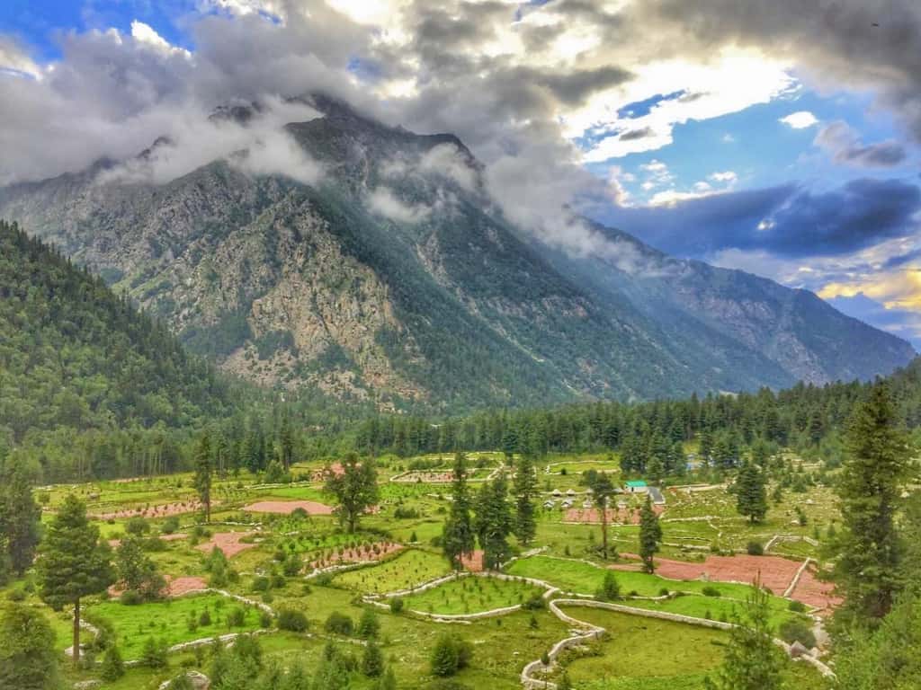
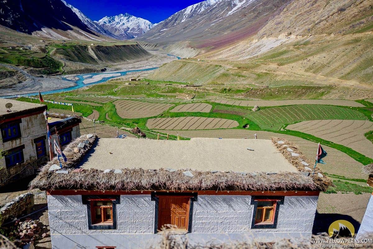
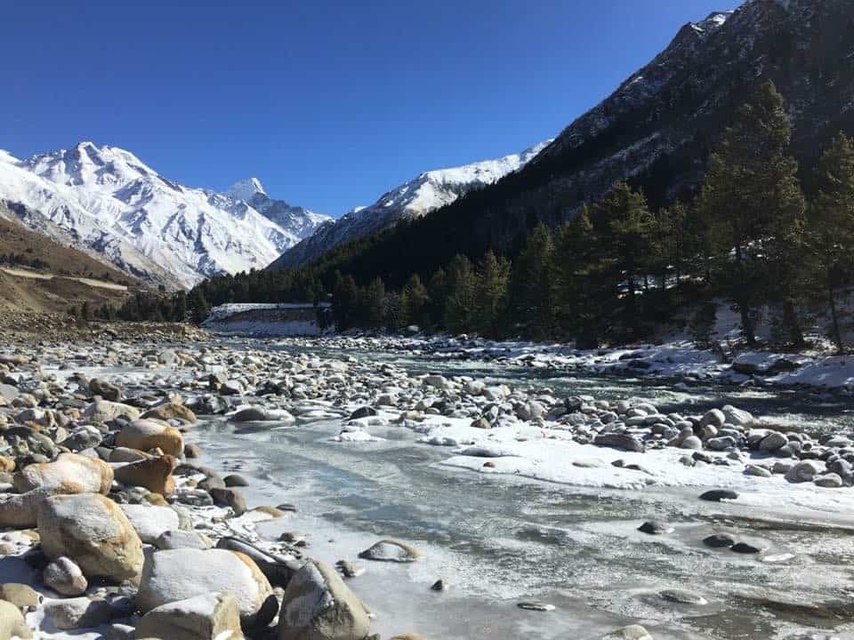
Most treks into Spiti start from Manali or Kaza and stay within the Spiti landscape throughout. The Pin-Bhabha Pass is different because the route itself is the experience. You are not just trekking to a viewpoint or a lake. You are crossing a hydrological and ecological boundary. On the Kinnaur side, the Bhabha Valley is fed by glaciers and monsoon runoff, so the terrain is green, the forests are dense, and the river crossings are frequent. On the Spiti side, you enter Pin Valley, which sits in a complete rain shadow and receives almost no monsoon rain. The transition happens in a matter of hours on the pass crossing day, and it is unlike anything most Indian trekkers have experienced.
The Hampta Pass is more popular, but it is also more crowded and shorter. The Pin-Bhabha Pass is longer, higher, more remote, and the gap between the two ecosystems is far more pronounced. If you have done Hampta and are ready for something harder and more rewarding, this is the natural next step. Keep in mind, however, that there is no bail-out point once you are past Phutsirang. The closest help is several hours of tough trail away in either direction.
According to Wikipedia, the Bhaba Pass sits on the boundary between Kinnaur district and Lahaul and Spiti district, bordering both Pin Valley National Park and the Rupi-Bhaba Wildlife Sanctuary. The pass altitude is confirmed at 4,890 m (16,040 Ft) by survey data. You may find trek operators quoting slightly different figures between 4,865 m and 4,915 m, but the Wikipedia/Survey of India figure of 4,890 m is the most reliable reference.
Pin-Bhabha Pass Trek Itinerary: Day-by-Day Route from Kafnu to Mudh
The standard trek itinerary runs six days on the trail, with a travel day from Shimla to Kafnu before and a drive from Mudh to Kaza on the final day. Here is the route that most trek groups follow, based on research from experienced operators who run fixed departures on this trail.
| Day | Route | Distance | Altitude | Time |
| Day 0 | Shimla to Kafnu (drive) | ~200 km | 2,400 m (7,874 Ft) | 8–10 hrs |
| Day 1 | Kafnu to Mulling | ~11 km | 3,200 m (10,500 Ft) | 6–7 hrs |
| Day 2 | Mulling to Kara | ~6 km | 3,550 m (11,650 Ft) | 4–5 hrs |
| Day 3 | Kara to Phutsirang | ~5 km | 4,200 m (13,780 Ft) | 4–5 hrs |
| Day 4 | Phutsirang to Baldar/Bwaldar (via Pass) | ~12 km | Pass: 4,890 m (16,040 Ft); Camp: 4,150 m (13,615 Ft) | 10–12 hrs |
| Day 5 | Baldar to Mudh | ~17 km | 3,810 m (12,500 Ft) | 7–8 hrs |
| Day 6 | Mudh to Kaza (drive) / onward | ~50 km | 3,650 m (11,975 Ft) | 2–3 hrs drive |
Day 1: Kafnu to Mulling (11 km, 6–7 hours)
The trail begins at Kafnu village, which sits along the Bhabha River at around 2,400 m. From the first day itself, you are in dense forests of oak and cedar, following the river upstream. Mulling, your first campsite, sits in a wide meadow at about 3,200 m with the river close by and mountains visible through the treeline. This is a relatively gentle first day, designed to start the acclimatisation process gradually. Most groups pitch tents here and spend the evening adjusting to the altitude.
Day 2: Mulling to Kara (6 km, 4–5 hours)
This is a shorter day in terms of distance but the terrain gets more open and the altitude gain is steady. Kara sits at around 3,550 m and the campsite here is one of the most scenic on the trek. There is a glacial lake nearby that reflects the surrounding peaks, and on clear days you can see the Hansbeshin peak. The shorter distance on Day 2 is intentional: it gives your body time to adjust before the big altitude gains in the following days. Do not push beyond Kara unless you are feeling completely well.
Day 3: Kara to Phutsirang (5 km, 4–5 hours)
The trail from Kara to Phutsirang involves a river crossing early in the day before the terrain opens up into higher altitude meadows. Phutsirang at 4,200 m is a rare river delta campsite, an unusual landform at this altitude where two streams meet. Vegetation thins noticeably here and you are above the treeline. This is the last comfortable campsite before the pass crossing. Make sure you eat well and sleep early tonight. The next day is the hardest of the entire trek.
Day 4: Phutsirang to Baldar via the Bhaba Pass (12 km, 10–12 hours)
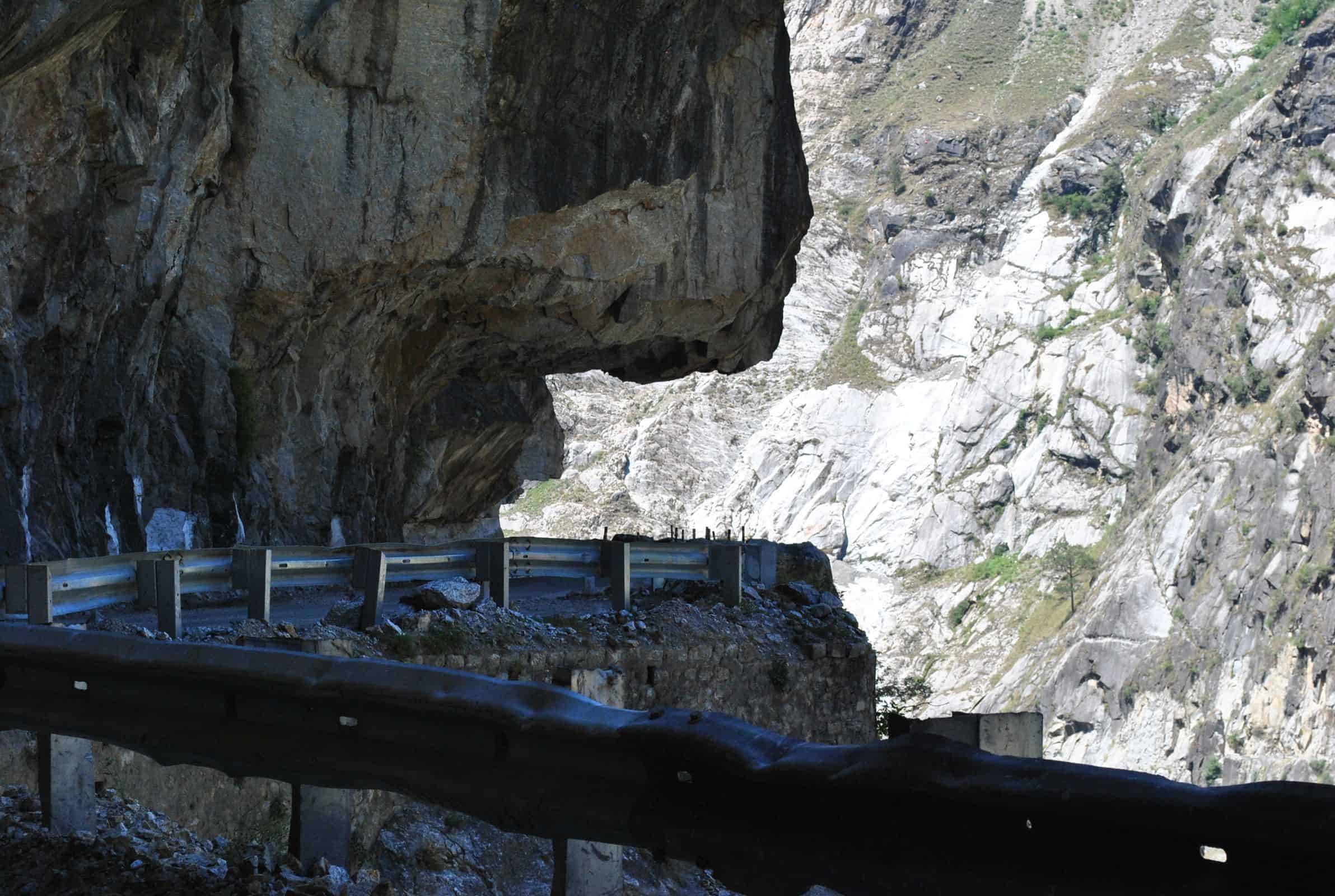
This is the summit day and the most demanding day of the trek. You start well before dawn, typically at 3–4 AM, to reach the pass before afternoon clouds build up. The ascent from Phutsirang to the pass at 4,890 m involves a glacier section near the top that requires care: the snow angle can be steep and the surface icy in the morning. Most groups use trekking poles, and some carry ice axes for this section. Your guide will advise on the current conditions as the glacier recedes year by year.
At the pass, you cross from the lush Kinnaur side into the high-altitude desert of Spiti. The view is startling: behind you, green valleys and glaciers; ahead, dry brown ridges and the barren expanse of Pin Valley stretching toward the horizon. The descent to Baldar (also called Bwaldar) at around 4,150 m is long and steep on loose scree. Take your time. The camp at Baldar is exposed but the sense of achievement after crossing the pass makes it one of the memorable nights of the trek. In case you feel any symptoms of AMS, including severe headache, nausea, or loss of coordination, do not attempt to sleep at altitude. Descend immediately with your guide.
Day 5: Baldar to Mudh (17 km, 7–8 hours)
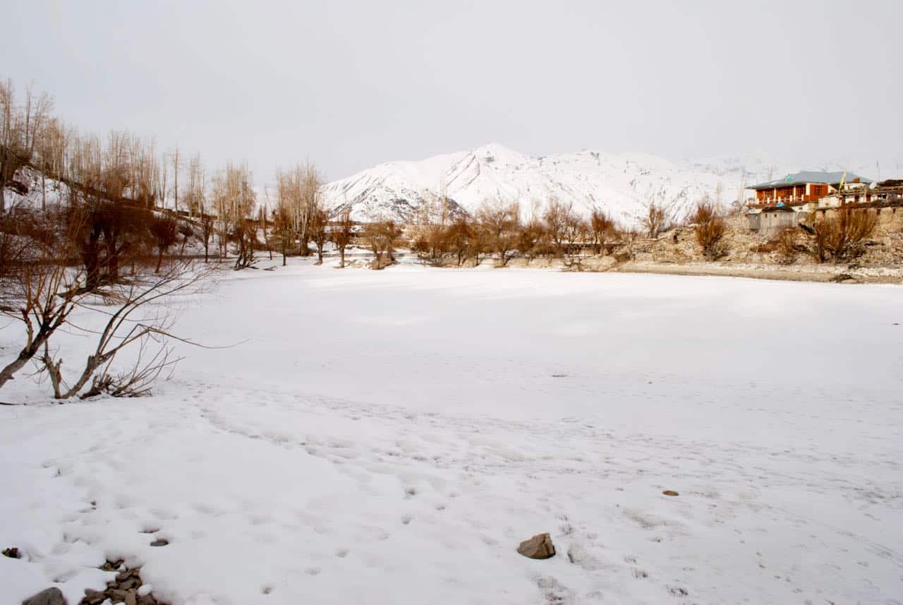
This is a long descent through the Pin Valley landscape into Mudh village. The terrain is completely different now: rocky, dry, lunar in places. You may spot Tibetan wolves, bharal (blue sheep), or golden eagles in the Pin Valley National Park zone. Mudh itself is a small village at 3,810 m with basic homestays and a handful of tea stalls. After days of camping in the wild, a hot meal and a roof over your head will feel like luxury. Our Pin Valley NP article covers Mudh village and the wildlife of Pin Valley in detail, so I suggest reading Pin Valley National Park 2026: Wildlife, Snow Leopard Spotting, and How to Reach from Kaza for what to expect after you arrive.
How to Reach Kafnu: Getting to the Trek Startpoint
Kafnu is approximately 200 km from Shimla along the NH-5 (now re-designated NH-5), taking 8–10 hours by road because of the winding mountain highway through Rampur and Wangtu. The closest major junction is Wangtu, which is about 20 km before Kafnu. You can also approach via Tapri.
For the most detailed and updated driving conditions on this route, I suggest checking our guide: NH-5 Road Status 2026: Shimla to Spiti via Kinnaur — Complete Driving Guide. The NH-5 passes through some technically challenging sections, especially between Rampur and Wangtu, and landslide closures are common in July and August.


By HRTC Bus: There is a daily HRTC bus from Shimla ISBT to Kafnu that departs around 8:00–8:40 AM and reaches Kafnu in the evening (approximately 6:00–6:30 PM). I would suggest verifying the current departure time directly with Shimla ISBT or the HRTC online portal at hrtchp.com before your trip, as bus timings change seasonally. If you miss the direct bus, you can take any Rampur-bound bus and then change at Wangtu for onward transport to Kafnu.
By Private Vehicle / Taxi: Hiring a taxi from Shimla to Kafnu is more comfortable and allows you to depart at a time that suits your itinerary. Shared taxis from Rampur to Kafnu are also available. If you are driving yourself, our Kinnaur Valley 7-Day Itinerary 2026 covers the Shimla to Wangtu and Tapri driving sections in detail and will help you plan the approach.
From Delhi: Delhi to Shimla is about 370 km (7–8 hours by road or Kalka-Shimla toy train + bus). From Delhi, the total journey to Kafnu is typically broken into two days: Delhi to Shimla overnight, then Shimla to Kafnu the next day.

Getting Out from Mudh: Onward to Kaza and Beyond
After finishing the trek at Mudh, your onward journey takes you deeper into Spiti. Mudh is about 50 km from Kaza via a dirt road that passes through Attargo and the Pin Valley floor. The drive to Kaza takes 2–3 hours by private jeep. There is no regular public bus between Mudh and Kaza, so most trekkers arrange a jeep pickup from Kaza in advance. The cost for a jeep from Kaza to Mudh return was approximately Rs 2,200–2,500 (for an Ertiga) as of 2025, but verify locally for current 2026 rates.
From Kaza, you can proceed to Manali via the Kunzum Pass (open typically from late June) or return to Shimla via the Kinnaur route (NH-5). Our Spiti Valley Budget Guide 2026 covers the full cost breakdown of staying, eating, and travelling in Spiti once you reach Kaza, which is useful for planning the post-trek portion of your trip.
Permits and Fees for the Pin-Bhabha Pass Trek
This is an area where I want to be careful not to give you numbers I cannot verify. The permit situation for this trek involves multiple authorities, and the specific fees for 2026 were not confirmed in any official government announcement I could find at the time of writing.
What is confirmed is that you need:
- Registration at Kafnu: You must register with the local forest department or village authority at Kafnu before starting the trek. This is mandatory and your guide will arrange it.
- Pin Valley National Park entry permit: Since the Spiti side of the pass falls within or adjacent to Pin Valley National Park, a wildlife/forest permit is required from the Spiti Wildlife Division or HP Forest Department office in Kaza. Most trek operators include this in their package.
- No Inner Line Permit for Indian citizens: As of 2026, Indian nationals do not require an ILP for Spiti Valley or Pin Valley. Foreign nationals should check with the HP Forest Department or the Spiti Wildlife Division for current regulations, as rules for foreigners in protected areas can change.
I suggest contacting the HP Forest Department office in Kaza or your trek operator to get the current 2026 permit fees before your trip, as I would rather you verify locally than give you a number that has changed. The permit amounts are generally modest but confirming them upfront avoids surprises at the trailhead.
Gear and Preparation: What You Need for This Trek
The Pin-Bhabha Pass is a Moderate-to-Strenuous trek at altitude. Do not underestimate it because it is less well-known. The pass day in particular involves glacier sections, a very early start, a 10–12 hour push, and a significant altitude gain followed by a long descent on loose ground. Here is what you genuinely need to carry:
- Layering system: Base layer (moisture-wicking), mid-layer (fleece), outer shell (waterproof windcheater). Temperatures at the pass can drop below freezing even in July.
- Trekking boots: Waterproof, ankle-supporting boots are essential. Do not attempt this in trail runners unless you have significant high-altitude trail experience.
- Trekking poles: Strongly recommended for both the ascent and the long scree descent on the pass day.
- Sleeping bag: Rated to at least -10°C. Nights at Phutsirang (4,200 m) and Baldar (4,150 m) will be cold.
- Sunscreen and sunglasses: UV exposure at altitude is severe. Use SPF 50 and UV-400 rated sunglasses, especially on the glacier section.
- First aid and medications: Diamox (acetazolamide) for AMS prevention is recommended. Consult your doctor before the trek. Carry Dexamethasone as an emergency AMS medication (guide should have it).
- Headlamp with spare batteries: For the 3 AM start on pass day.
- Water purification: Tablets or a filter. Stream water is generally clean but purification is safer.
Trek operators providing guided packages typically supply tents, sleeping mats, kitchen equipment, porters, and a cook. Personal gear is your responsibility. Keep your pack weight below 8–10 kg if you are doing this without porters. Anything heavier at 4,000+ m altitude makes the trek significantly harder.
Best Time to Do the Pin-Bhabha Pass Trek
The pass typically opens in late June, once the snow on the approach has melted enough to be safe for trekking. The season runs through mid-September. Here is how the window breaks down month by month:
June (late June only): The pass may still have significant snow and ice. Trail conditions on the Kinnaur side can be wet and slushy. Best for experienced trekkers with prior high-altitude experience. The weather is generally clear. Do not attempt before June 20 without confirming conditions with a local operator.
July and August: This is the prime window. The Bhabha Valley side gets some moisture from the monsoon but the pass area and Pin Valley remain largely rain-shadow dry. This is when most trek groups operate. The views are green on the Kinnaur side and dramatically clear on the Spiti side. Keep in mind that river levels are higher during monsoon, so stream crossings on Days 1–3 can be more challenging.
September: Excellent visibility, drier trails, lower river levels. The snowline starts descending in late September and the pass can receive fresh snow. Most operators finish their season by mid-September. This is arguably the best month for photography.
Outside this window, the pass is generally closed due to snow. Do not attempt it in October or later without current ground reports from the HP Forest Department or a local Kaza-based guide.
Accommodation and Camping on the Trek
For most of the trek route (Mulling, Kara, Phutsirang, Baldar), camping is the only option. There are no guesthouses or villages along the trail between Kafnu and Mudh. Hence, the trek must be done with either:
- A registered trek operator: Who provides tents, sleeping bags, a cook, porter support, and an experienced guide. This is strongly recommended for first-timers on this route.
- A self-organised camping setup: If you have prior high-altitude camping experience, carry all your own gear, and have a local guide hired from Kafnu or Kaza who knows the route.
At Kafnu, there are basic guesthouses in the village for the night before the trek. At Mudh, homestays are available. The quality is basic: expect shared bathrooms, local food (dal, rice, chapati), and no electricity reliability. As of research done for this article, homestay rates in Mudh were approximately Rs 500–800 per person per night including meals, but verify locally as rates have been increasing each season.
For camping tips specific to Kinnaur, you can also refer to our Tips for Camping in Kinnaur, Himachal Pradesh.
Cost Breakdown: What to Budget for the Pin-Bhabha Pass Trek
Trek costs vary significantly depending on whether you go with an organised package or set it up independently. Here is an honest breakdown of what to expect in 2026. Note that I have used approximate ranges based on available research, and actual costs should be confirmed with operators directly as prices change every season.

| Cost Component | Budget (DIY) | Organised Package |
| Transport Shimla to Kafnu (bus) | Rs 300–500 (HRTC) | Included or ~Rs 1,500 (taxi share) |
| Transport Mudh to Kaza (jeep) | Rs 400–600 per person (shared) | Included |
| Trek guide (local, 6 days) | Rs 1,500–2,000/day | Included |
| Porters (if needed) | Rs 800–1,200/day per porter | Included |
| Camping gear rental | Rs 300–600/day | Included |
| Food on trek (cook + provisions) | Rs 500–700/day per person | Included |
| Kafnu guesthouse (1 night) | Rs 400–700/person | Included |
| Mudh homestay (1 night) | Rs 500–800/person with meals | Included |
| Permits (forest/wildlife) | Verify with HP Forest Dept | Included |
| Total DIY estimate (7 days) | Rs 12,000–18,000 per person | |
| Organised package (all-inclusive) | Rs 16,000–25,000 per person |
The organised package range above is based on general market research. Trek operators offer varying levels of service, group sizes, and itineraries. Get quotes from at least two or three operators and confirm exactly what is and is not included. Some operators quote ex-Shimla, others ex-Kafnu. Make sure you are comparing apples to apples.
For a broader understanding of costs once you are in Spiti after the trek, I suggest checking our Spiti Valley Budget Guide 2026, which covers accommodation, food, and travel costs in Kaza and across the valley in detail.
Safety and AMS: What You Must Know Before You Go
I want to be direct about this section because the Pin-Bhabha Pass trek reaches 4,890 m, and that is high enough for Acute Mountain Sickness (AMS) to become a serious problem. AMS does not discriminate by fitness level. I have seen fit people struggle at altitude and sedentary people do fine. It is about how your body responds to lower oxygen levels, and you cannot predict it in advance.
AMS warning signs to watch for: Persistent headache that does not go away with paracetamol, nausea or vomiting, loss of appetite, dizziness, and difficulty sleeping. These are early warning signs. More serious signs include confusion, loss of coordination, persistent dry cough, and blue-tinged lips or fingernails. If any of the serious signs appear, you must descend immediately. Do not sleep at altitude with these symptoms. Descend first, evaluate later.
Acclimatisation is built into the itinerary: The shorter Day 2 (Mulling to Kara) and the night at Kara before pushing to Phutsirang are deliberate acclimatisation steps. Do not try to rush the itinerary to save a day. The itinerary is designed the way it is for your safety.
Diamox: Consult your doctor before the trek about acetazolamide (Diamox) as a preventive medication. Many trekkers on this route take it from Day 1. The standard prophylactic dose is 125 mg twice daily starting 24 hours before significant altitude gain. Do a trial dose at home first to check for side effects (tingling in the fingers and toes is common and harmless; a sulfa allergy is a contraindication).
Mobile network: There is essentially no mobile coverage on the trail between Kafnu and Mudh. BSNL has marginal signal at some points but do not rely on it for emergencies. Your guide’s local knowledge is your primary safety net. Make sure someone knows your planned itinerary and expected arrival date at Mudh before you start.
Frequently Asked Questions about the Pin-Bhabha Pass Trek
What is the exact altitude of the Pin-Bhabha Pass?
According to Wikipedia and Survey of India data, Bhaba Pass sits at 4,890 m (16,040 Ft). You will find different operators quoting between 4,865 m and 4,915 m, but 4,890 m is the most reliable figure based on authoritative sources. The discrepancy comes from different measurement methods and rounding by various operators.
Is the Pin-Bhabha Pass trek suitable for beginners?
I would not recommend it for first-time trekkers. This is rated Moderate-to-Strenuous with a glacier section on the pass day that requires confidence at altitude and on snow/ice terrain. If you have not done a multi-day high-altitude trek before, I suggest starting with Hampta Pass or a similar Grade 3 trek first. If you have done Hampta and are comfortable at 4,000 m, the Pin-Bhabha Pass is a logical next step.
Do I need a guide for this trek?
Yes, strongly. The trail beyond Kara is not well-marked and route-finding on the glacier and scree sections of the pass day is not straightforward. There are no settlements between Kafnu and Mudh to ask for help. An experienced local guide is not optional on this trek. Hire one from Kafnu village or through a registered trek operator based in Shimla, Rampur, or Kaza.
Can the trek be done in the reverse direction (Mudh to Kafnu)?
Yes, it can be done in either direction. The Kafnu-to-Mudh direction is more common because it follows a gentler gradient on the Kinnaur side before the steep summit day. Going Mudh to Kafnu means ascending the steep Spiti-side slopes first and descending the more forested Kinnaur side. Both directions are viable. The logistics of getting to Mudh from Kaza first (before doing the trek) versus doing the trek and arriving in Spiti are the main planning consideration.
What permits do Indian trekkers need?
Indian nationals need to register at Kafnu with the local forest/village authority and obtain a wildlife/forest permit for the Pin Valley National Park zone on the Spiti side. No Inner Line Permit is required for Indian nationals in Spiti as of 2026. Your trek operator will typically arrange all permits. If you are going independently, contact the HP Forest Department office in Kaza or Reckong Peo before your trek to confirm current requirements and fees.
Is there ATM or fuel availability near Kafnu?
No ATM is available at Kafnu itself. The nearest reliable ATM is at Rampur, about 50–60 km before Kafnu on the NH-5. Carry sufficient cash for the entire trek before reaching Rampur. For fuel, there are petrol pumps at Rampur and at Tapri. Fill up before heading to Kafnu. There is no petrol pump at Kafnu or beyond on the Bhabha Valley route.
What happens if weather closes the pass?
Unexpected snowfall can close the pass even in July and August. If this happens, your guide will assess whether to wait a day at Phutsirang for conditions to improve or whether to turn back to Kara. This is a judgment call that experienced local guides make based on real-time conditions. Build a one-day buffer into your overall trip itinerary to account for this possibility. Do not book fixed flights or bus tickets for the day after your expected arrival in Mudh.
How different is Pin Valley from the Kinnaur side of the trek?
Dramatically different. The Bhabha Valley side of the pass is green, forested, and river-fed with dense vegetation up to about 3,800 m. The moment you cross the pass and start the Spiti-side descent, the landscape turns to dry brown rock, sparse grasses, and wide open treeless terrain. Pin Valley receives very little rainfall. The transition is so sharp that experienced trekkers often describe crossing the pass as entering a different country. That contrast is the main reason this trek is worth doing.
What wildlife can I expect to see on this trek?
On the Kinnaur (Bhabha Valley) side, you may encounter Himalayan monal pheasants, snow cocks, marmots, and various raptors. On the Spiti (Pin Valley) side, bharal (blue sheep) are frequently spotted on the rocky slopes, and Tibetan wolves have been seen in the area. Snow leopards are present in Pin Valley National Park but sightings are rare and occur mostly in winter when prey descends to lower altitudes. For a detailed guide to Pin Valley wildlife, see our Pin Valley National Park 2026 article.
Is the Pin-Bhabha Pass Trek Worth It?
For trekkers who have done the standard Himachal routes and want something that feels genuinely different, the Pin-Bhabha Pass delivers on every count. You start in an apple orchard valley and finish in a high-altitude desert. The pass crossing at 4,890 m is demanding but achievable for anyone with prior multi-day high-altitude experience. And the complete absence of any road access through this pass means the trail retains a sense of remoteness that is increasingly rare in the more popular Himalayan trek zones.
Based on research from multiple travelers and operators who have done this route, the consensus is that Days 3 and 4 (Kara to Phutsirang and the pass crossing day) are where the trek earns its Moderate-to-Strenuous rating. If you can handle those two days, the rest of the route is within reach for any reasonably fit trekker who has trained for altitude.
Go in July or August for the best combination of open trail, reasonable weather, and the dramatic green-to-desert contrast. Go in September if photography is your primary goal. And please, build a buffer day into your trip. Mountains on their own schedule, not yours 🙂 …
If you are planning to combine this trek with a broader Kinnaur and Spiti trip, our Kinnaur Valley 7-Day Itinerary will help you plan the Shimla to Kafnu approach, and our Pin Valley National Park guide covers what to do once you arrive in Mudh and the broader Pin Valley area. For another serious high-altitude option in the same district, see my guide to the Kinnaur Kailash Parikrama trek, a sacred circuit around Kinner Kailash via Charang La.
If you have any questions about the Pin-Bhabha Pass trek, or if you have done this route and want to share your experience, feel free to ask in the comments section below 🙂