Are you planning to drive from Shimla to Spiti Valley via Kinnaur this summer and trying to figure out the current status of NH-5 (the Hindustan Tibet Road)? You have come to the right place. NH-5 is the lifeline that connects mainland Himachal to Kinnaur and Spiti, and it is also one of the most fascinating, and at times unpredictable, highways in the country. As of May 2026, the road is open end to end, but there are sections that demand your full attention. In this guide, I will walk you through the current 2026 status, the route broken down kilometre by kilometre, the troublesome stretches you must know about, vehicle requirements, permit rules, and the driving practices I have learned over years of driving this road.
I am writing this in mid-May 2026, which is the start of the peak planning window for Spiti road trips. Most travellers I speak with are deciding between the Manali side and the Kinnaur side. If you are picking Kinnaur, then NH-5 is the road you will spend most of your time on. Let us look at the details so you can plan with confidence.
What is the Current Status of NH-5 in May 2026?
As of May 2026, NH-5 is OPEN from Shimla all the way through Kinnaur to Sumdo, where it crosses into Spiti district. Unlike the Manali to Kaza road via Kunzum Pass, which stays closed for almost 7-8 months a year, NH-5 is operational year-round, although certain stretches near Pooh and Khab can get cut off for short periods due to snow or landslides in peak winter and during the monsoon.
The Border Roads Organisation (BRO) and the Himachal Pradesh PWD share responsibility for this highway. Based on the latest news reports and traveller updates from the DwD Community, the troublesome zones to keep on your radar this season are Tranda Dhank near Nigulsari (km 115-120 area), Chaura, and Maling Nallah between Pooh and Sumdo. These are the spots that historically close the road during monsoon. Pre-monsoon (May, June) and post-monsoon (mid-September to November) are the safest months to drive this route.
Quick Answer: NH-5 from Shimla to Sumdo (Spiti border) is open as of May 2026. The drive covers approximately 470 km and takes 2 to 2.5 days at a comfortable pace. Critical sections to watch are Tranda Dhank near Nigulsari, Chaura, and Maling Nallah. A high-clearance vehicle is recommended beyond Karcham, although hatchbacks and sedans manage the road in dry weather with careful driving.
Practical Info Box | NH-5 Shimla to Spiti via Kinnaur
- Total distance (Shimla to Sumdo): About 470 km
- Driving time: 18 to 20 hours of pure driving, ideally split across 2 to 3 days
- Best time to drive: Mid-April to mid-June, mid-September to November
- Monsoon caution: Heavy risk between mid-July and early September
- Status as of May 2026: OPEN end to end
- Permits: Inner Line Permit required for Indian travellers beyond Jangi (heading toward Spiti). Not required for stops in Sangla, Chitkul, or Kalpa.
- Vehicle: High-clearance SUV recommended past Karcham. Hatchbacks and sedans doable in dry conditions with careful driving.
- Fuel pumps en route: Shimla, Narkanda, Rampur, Jeori, Wangtu, Reckong Peo, Pooh, Sumdo (always tank up at Reckong Peo as a buffer)
- Last verified: May 2026
Route Breakdown: Shimla to Sumdo Kilometre by Kilometre
NH-5 has been renumbered over the years. What was historically the NH-22 (the Hindustan Tibet Road) is now part of NH-5 in the national highway grid. The road starts from Shimla and goes all the way to the India-China border at Shipki La in Kinnaur, but for travellers heading into Spiti, the relevant stretch ends at Sumdo, where you turn left onto the road towards Tabo and Kaza.
| Section | Distance from Shimla | Driving time | Road condition (May 2026) |
|---|---|---|---|
| Shimla to Narkanda | 65 km | 2 hrs | Excellent tarmac, gentle climbs |
| Narkanda to Rampur | 83 km | 3 hrs | Good, mostly downhill to Sutlej valley |
| Rampur to Wangtu / Jeori | 105 km | 3 to 3.5 hrs | Mostly good, watch Chaura zone |
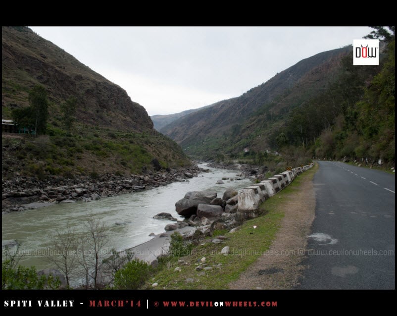
| Wangtu to Karcham | 120 km | 4 hrs | Tranda Dhank stretch, drive carefully |
| Karcham to Reckong Peo / Kalpa | 136 km | 5 hrs | Mixed, narrow sections, beautiful views |
| Reckong Peo to Pooh / Moorang | 180 km | 6.5 hrs | Patchy, climb begins toward higher Kinnaur |
| Pooh to Khab | 205 km | 7.5 hrs | Narrow Gyaba section, dramatic landscape |
| Khab to Sumdo (Spiti border) | 220 km | 8 hrs | Maling Nallah, slide-prone but doable |
Keep in mind, these are pure driving times. Add at least 30-40% extra for tea breaks, photo stops, fuel halts, lunch, and BRO holdups. A realistic Shimla to Sumdo drive over two days looks like this: Day 1, Shimla to Reckong Peo or Kalpa (240 km); Day 2, Kalpa to Sumdo and onward to Tabo (245 km). Doing it in one day is technically possible but punishing on the body, especially if you are gaining altitude.
Which Sections of NH-5 are Genuinely Dangerous?
There are four stretches I want you to be honest about with yourself before you start. If you have done mountain driving before, you will manage. If this is your first hill drive, you must mentally prepare for these zones.
Quick Answer: The four critical sections on NH-5 are (1) Tranda Dhank near Nigulsari around km 115-120, (2) Chaura landslide zone between Jeori and Wangtu, (3) the Gyaba narrow section near Pooh, and (4) Maling Nallah between Khab and Sumdo. None are impassable in dry weather, but all demand slow, focused driving.
1. Tranda Dhank (Nigulsari, km 115-120)
Tranda Dhank is a sheer cliff face cut by BRO into the mountain wall above the Sutlej. The road here clings to the rock with absolutely no margin on one side. The dhank (the overhanging cliff) is unstable and historically the site of major landslides. In recent years the BRO has installed steel mesh on parts of the cliff, but the section remains finicky during rain. As per traveller reports through May 2026, the section is open and dry. Drive through it without stopping for photos. The locals do not stop here, neither should you.
2. Chaura Landslide Zone (Between Jeori and Wangtu)
Chaura has had multiple closures over the years, the most notable being the 2021 landslide that blocked the road for days. As of 2026, the road is open and BRO has been working on slope stabilisation in this area. You will still see scars on the hillside. Do not idle here. Keep moving.
3. Gyaba Narrow Section (Near Pooh)
Once you cross Reckong Peo and head deeper into upper Kinnaur, the road narrows considerably near Gyaba. There are sections where two cars can pass only with one tucking into a cut. Vehicle clearance matters here because the road surface is uneven, and a low-slung sedan can scrape the underbody on the rougher patches. The good news, traffic here is light. Most of the cars and buses you will cross are headed in the same direction.
4. Maling Nallah (Between Khab and Sumdo)
Maling Nallah is the section everyone talks about. It sits between Khab and Sumdo, and it is essentially a landslide zone that does not rest. BRO bulldozers are stationed nearby and clear the muck on most days. Even in dry season, you will see fresh debris on the road. In peak summer (June and July), Maling Nallah can also get water flowing across the road from snow melt above. The crossing itself takes 2-3 minutes if the road is clear. If BRO is clearing it when you arrive, you might wait 30 minutes to a few hours. Carry water and biscuits.
For more on handling these mountain water crossings, you can also refer to my guide on how to safely handle water crossings on a Ladakh, Zanskar, or Spiti Valley trip.


Do You Need a Permit to Drive on NH-5?
This is one of the most asked questions, and the answer depends on how far you are going.
- Shimla to Reckong Peo, Kalpa, Sangla, Chitkul, Sarahan: No permit required for Indian nationals.
- Reckong Peo to Pooh, Khab, Nako, Sumdo (heading into Spiti): Inner Line Permit (ILP) required for Indian nationals because the route runs close to the India-Tibet border.
- For foreign nationals: Protected Area Permit required, applied for through a registered agent.
The ILP for Indian nationals is issued at the SDM office in Reckong Peo. It is free of charge, valid for 7 days, and you need to carry a photo ID (Aadhaar or passport), two passport photos, and a self-declaration form. The office is generally open Monday to Saturday, 10 AM to 5 PM, with a lunch break. Plan to reach Reckong Peo in the first half of the day if you need a permit, because the office closes early on Saturdays and stays shut on Sundays and government holidays.

The permit also gets checked at the police nakka at Jangi, about 25 km from Pooh. The officials are courteous but thorough. Keep your permit photocopies handy. I usually carry 4-5 copies because they collect one at each checkpoint.
What Vehicle Should You Take on NH-5?
Honestly, I have driven NH-5 in everything from a hatchback to an SUV, and here is my real-world breakdown.
- Hatchback (Swift, i20, Baleno, Polo): Doable up to Kalpa and Chitkul in dry weather. Beyond Reckong Peo, low clearance becomes a problem near Gyaba and Maling Nallah. Manageable if you drive slowly and pick your line carefully. Not recommended in wet weather.
- Sedan (Dzire, Verna, City): Same as hatchback in terms of clearance limits. Drive cautiously past Karcham.
- Compact SUV (Brezza, Sonet, Venue, Nexon): Comfortable up to Sumdo. Higher ground clearance handles the rough patches near Gyaba and Maling Nallah without scraping. My recommendation for most travellers.
- Full SUV / 4X4 (Thar, Scorpio, Endeavour, Fortuner): The ideal vehicle for this road. You get clearance, power on climbs, and confidence in low-traction conditions. Not strictly necessary, but if you have one, take it.
- Motorcycle (Royal Enfield, Himalayan, ADV bikes): The most fun way to do NH-5. Just make sure your tyres are fresh and you have rain gear, even in May.
If you are renting a self-drive car, my honest opinion is to spend the extra Rs 500-800 per day for a compact SUV over a hatchback for this route. The peace of mind is worth it. You can read more on the rental side at my guide on how to hire a self-drive car for Ladakh or Spiti Valley.
Fuel, Mobile Network, and Mechanic Availability on NH-5
This is the section that saves trips. Plan your fuel and connectivity carefully because the further you go from Shimla, the thinner the support gets.
Fuel Pumps on NH-5
- Shimla (multiple)
- Theog (about 30 km from Shimla)
- Narkanda
- Rampur (multiple, last big town with reliable pumps)
- Jeori
- Tapri / Wangtu area
- Reckong Peo (always tank up here, this is your last reliable pump before Spiti)
- Pooh (sometimes operational, do not rely)
- Sumdo (small pump, limited stock)
The golden rule on NH-5 is, fill up at Reckong Peo. Treat anything beyond Peo as a bonus. If your vehicle has a 35-40 litre tank and gives 12-15 km per litre, you have a 450-500 km range, which is enough to reach Kaza without refuelling once you tank up at Reckong Peo. Carry an extra 5 to 10 litres in a jerry can if your vehicle is thirsty or if you plan side trips to Nako, Gyu, or Chitkul.
Mobile Network on NH-5
BSNL is your friend on NH-5. Jio works up to Reckong Peo and patchily till Pooh. Airtel works in Shimla, Narkanda, Rampur, and Reckong Peo, with very limited coverage beyond. Vi has the weakest reach. If you do not have a BSNL prepaid SIM, get one in Shimla before you start. Even basic call connectivity disappears between Pooh and Sumdo, and in the deep gorges near Tranda and Maling Nallah.
Mechanic and Tyre Help
Decent mechanics are available in Shimla, Theog, Rampur, and Reckong Peo. Beyond that, you are looking at small puncture-repair tyre shops only. Carry a basic tool kit, a spare tyre that has been freshly checked, a foot pump or compact electric inflator, and tow rope. If you are on a motorcycle, carry a puncture repair kit and a spare tube. You can also read my detailed guide on how to prepare your bike for Ladakh or Spiti.
When is the Best Time to Drive NH-5?
Quick Answer: The two best windows to drive NH-5 are mid-April to mid-June (pre-monsoon) and mid-September to November (post-monsoon). These months have stable weather, clear skies, low landslide risk, and reasonable temperatures.
Month by Month Quick Reference
- April: Snow may still linger near Sumdo and Nako. Sangla, Chitkul, Kalpa are accessible. Cold mornings.
- May: Excellent month. Most travellers start hitting the road. Apple blossom season in lower Kinnaur. This is when I am writing this article.
- June: Peak season. Sumdo and Spiti border fully accessible. Some snow-melt water at Maling Nallah.
- July: Monsoon enters. Higher risk at Tranda, Chaura, Maling Nallah. Drive only if you can be flexible with closures.
- August: Worst month for NH-5. Avoid unless you have specific reasons (e.g., apple orchard tours, Mandi-Kullu festivals nearby).
- September (mid-onwards): Monsoon retreats. Road stabilises. Great month again.
- October: Crisp weather, low traffic, golden poplars. One of my favourite months.
- November: Cold but doable till early month. Snow can start by end of month at Nako and beyond.
- December to March: Snowfall closes the upper sections intermittently. Lower Kinnaur (Sangla, Chitkul, Kalpa) is doable for winter trips. Read my Kinnaur in winter tips for more.
For a deeper month-by-month picture, also see my detailed best time to visit Kinnaur Valley guide.
Driving Tips From My NH-5 Experience
Over the years, I have made my share of mistakes on this road. Here are the practices that have made my drives safer and more enjoyable.
- Start early, finish by mid-afternoon. The Sutlej valley is prone to wind in the afternoons, and visibility worsens. Try to be off the road by 4 PM if you can. For the troublesome stretches (Tranda, Chaura, Maling Nallah), cross them before 11 AM ideally.
- Do not stop in active landslide zones. Tranda Dhank and Maling Nallah are not photo spots. Drive through. You will get plenty of beautiful stops elsewhere.
- Yield to uphill traffic. Mountain etiquette. If you are going downhill, you stop and let the uphill vehicle pass on narrow stretches. Buses and trucks have right of way always.
- Engage lower gears on descents. Do not ride the brakes. The descent from Narkanda to Rampur is long, and your brake fade is a real risk if you keep them pressed.
- Carry cash. ATMs work in Shimla, Rampur, and Reckong Peo. Beyond that, treat cash as your only payment option. Carry at least Rs 5,000 to Rs 10,000 in small notes.
- Buy supplies in Rampur or Reckong Peo. Anything from medicines to specific brand snacks needs to be picked up here. The villages further on stock basics only.
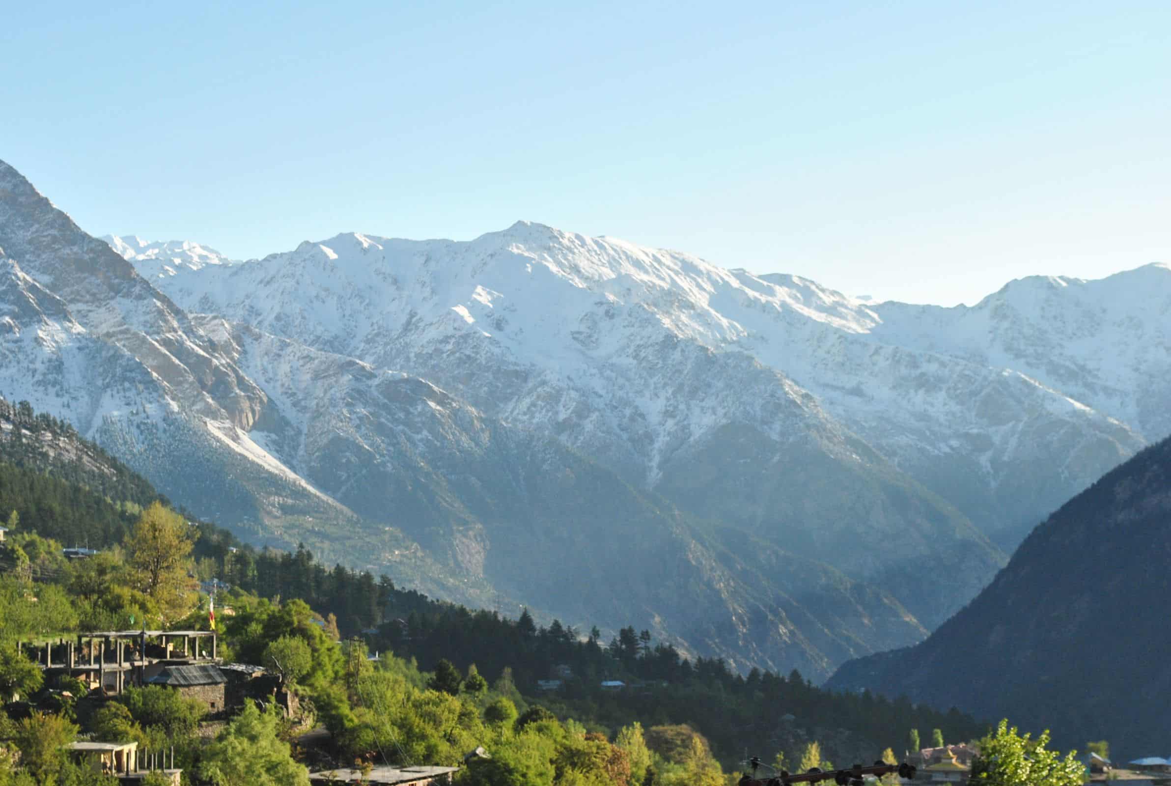
- Drink water and acclimatise. Reckong Peo sits at about 7,500 feet, Kalpa at 9,700 feet, Nako at 12,000 feet. The altitude gain is gentler than the Manali side, which is one of the reasons I recommend the Kinnaur route for first-timers. Still, hydrate properly and take it slow.
- Inform someone of your route. Share your day plan with a friend or family member. With patchy network, regular check-ins are not guaranteed.
What to Do if the Road Closes While You are Driving
Landslides on NH-5 are mostly a monsoon issue, but they can happen any time. If you find yourself stopped because of a closure ahead, here is the playbook.
- Stay calm and stay in your vehicle unless instructed otherwise by police or BRO.
- Do not try to walk past a fresh slide. Falling stones are the real danger, not the slide that already happened.
- Check with locals or drivers ahead. They will know if it is a 2-hour clearance or a 2-day one.
- Note nearest village. If clearance looks long, head back to the nearest village for a homestay rather than camping by the road. Sangla, Kalpa, Reckong Peo, Pooh, Nako are all options.
- Follow HP Police and BRO social handles. Both put out updates. Also keep a BSNL number handy because Jio and Airtel will fail you in the worst of the gorges.
The Kinnaur police PCR vans are stationed near Wangtu, Karcham, and Reckong Peo. If you have a medical or vehicle emergency, dial 112 (the all-India emergency number) and they will route you accordingly.
Two-Day Driving Plan for NH-5 (Shimla to Spiti)
If you have only two days to cover NH-5 before entering Spiti proper, this is the plan I would suggest. It gives you time to enjoy the road without rushing through the dangerous bits.
Day 1: Shimla to Kalpa (240 km, 8-9 hours including stops)
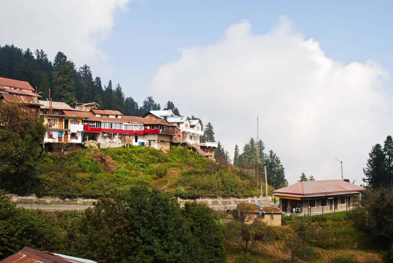
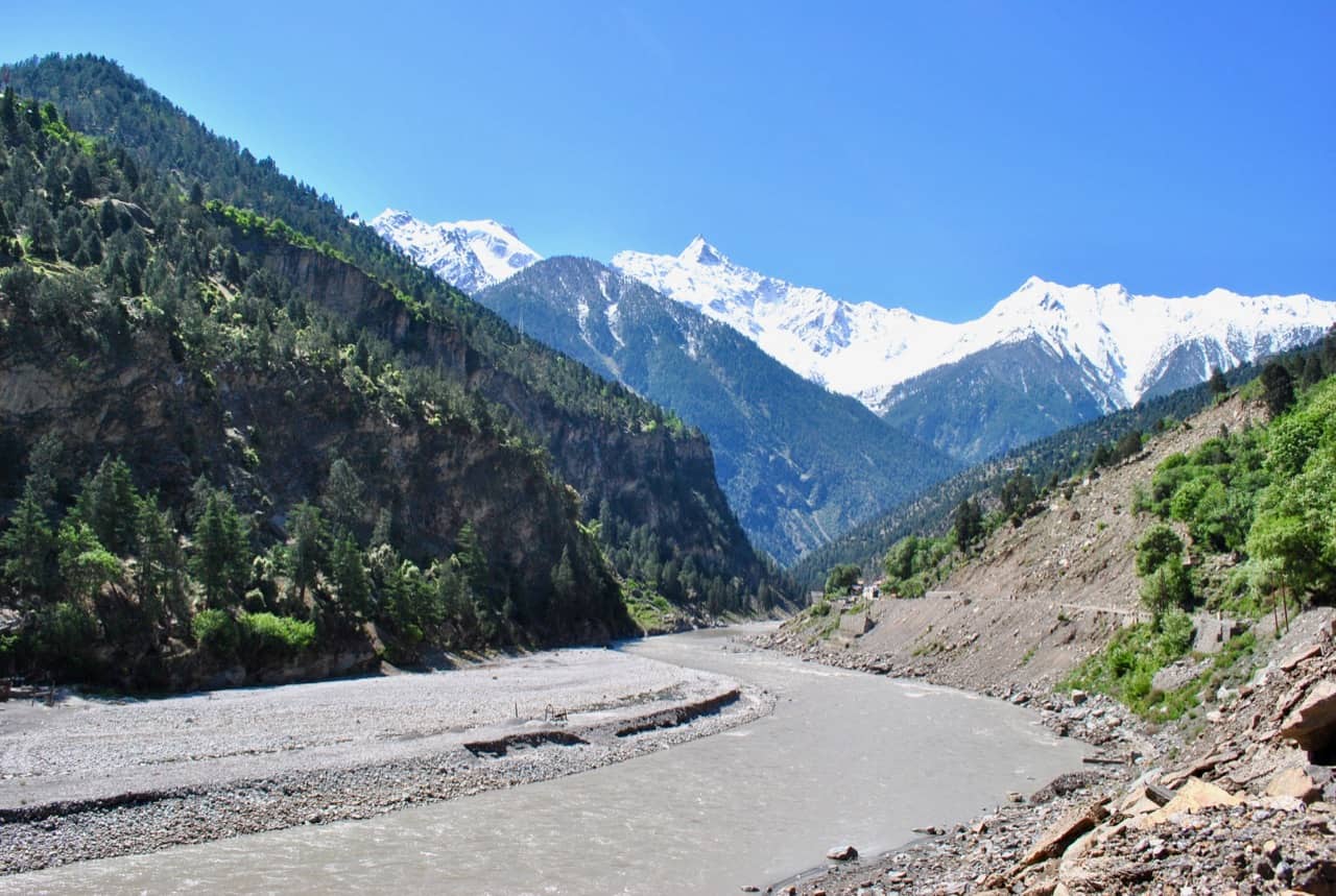
Start from Shimla by 6 AM. Reach Narkanda by 8 AM for breakfast. Drive on to Rampur, lunch at HPTDC Cafe Satluj. Continue to Jeori, take the optional detour to Sarahan (16 km off NH-5) for the Bhimakali temple if you have time. Otherwise push to Karcham, then up the Karcham-Kalpa road to reach Kalpa by 5 PM. Stay overnight at Kalpa. The views of Kinner Kailash at sunset are something else.

Day 2: Kalpa to Tabo via Sumdo (245 km, 9-10 hours)
Start by 7 AM. Drop down to Reckong Peo, collect your Inner Line Permit by 9 AM if not already done. Drive to Pooh for a quick tea. Continue past the Khab bridge (where Spiti river meets Sutlej, a stunning confluence). Cross Maling Nallah carefully, then reach Sumdo by 3 PM, where you officially enter Spiti district. Push on to Tabo for the night.
For a deeper Kinnaur exploration before Spiti, you can split this into 3 days and add a night at Chitkul. See my Kinnaur Valley travel guide and my Spiti Valley via Kinnaur planning guide for more layered options.
Frequently Asked Questions About NH-5
Is NH-5 open in May 2026?
Yes, NH-5 is OPEN end to end as of May 2026, from Shimla to Sumdo and onwards into Spiti. The road is clear of snow up to Nako, and the troublesome sections (Tranda, Chaura, Maling Nallah) are passable.
Can I drive a sedan from Shimla to Spiti via Kinnaur?
Yes, in dry weather. Hatchbacks and sedans regularly do this route. The trouble spots are clearance near Gyaba and underbody scrape risk on rough patches between Khab and Sumdo. Drive slowly and you will be fine.
Do I need a permit to enter Kinnaur or Spiti?
For lower Kinnaur (Sarahan, Sangla, Chitkul, Kalpa, Reckong Peo), no permit is required for Indian citizens. For upper Kinnaur beyond Jangi (Pooh, Khab, Nako) and into Spiti, an Inner Line Permit is required and is issued free at Reckong Peo SDM office.
How dangerous is Maling Nallah?
Maling Nallah is an active landslide zone but it is managed daily by BRO. In dry weather, you cross it in 2-3 minutes. In monsoon, expect delays of 30 minutes to a few hours. Closures of multiple days are rare in pre and post monsoon seasons.
Is the Manali to Spiti route safer than NH-5 via Kinnaur?
Both routes have their own risks. Manali side has Rohtang traffic, Gramphu bottleneck, and Kunzum Pass closing in winter. Kinnaur side has Tranda, Chaura, and Maling Nallah. Kinnaur side wins on altitude gain (gentler), open season (year-round to Reckong Peo), and scenery diversity. For first timers, I recommend going up via Kinnaur and coming back via Manali.
What is the toll on NH-5?
There are no toll plazas on NH-5 in the Kinnaur stretch. The road is non-tolled given its remote nature. You may encounter small parking charges (Rs 20-100) at temple complexes like Bhimakali Sarahan, or at viewpoints near Chitkul. Verify locally.
Is there a bus service along NH-5?
Yes. HRTC runs daily buses from Shimla to Reckong Peo, Kalpa, Sangla, and Pooh. There is also a long-haul Shimla to Kaza bus that runs in the summer months. Schedules vary, so verify with HRTC ISBT Tutikandi in Shimla before planning a bus trip. For a public-transport-only Kinnaur trip, see my budget trip to Kinnaur by public transport guide.
Can I drive NH-5 in one day from Shimla to Kaza?
Technically yes, around 530 km, but I would strongly advise against it. The drive is exhausting, you miss the highlights, and you risk altitude-related issues by gaining 7,000+ feet too fast. Always split it into at least 2 days, ideally 3.
Will I get altitude sickness on NH-5?
NH-5 gains altitude gradually, which is its big advantage. Most travellers do not experience AMS up to Reckong Peo or Kalpa. Above Nako (12,000 feet) and into Sumdo, mild symptoms (headache, breathlessness) can show up. Hydrate, avoid alcohol the night before high-altitude entry, and read my 12 tips to prevent AMS guide before the trip.
Where can I find the latest BRO updates on NH-5?
The Himachal Pradesh Police regularly publishes road condition updates on their official channels. Local news outlets like Himachal Watcher and The Tribune also carry NH-5 closure reports during monsoon. For real-time community updates, the DwD WhatsApp groups and our YouTube channel often share current observations from travellers on the road.
Final Thoughts on Driving NH-5 in 2026
NH-5 is one of the great Himalayan road trips. It is not as marketed as the Manali to Leh highway, but for my money, it is the more rewarding drive of the two. You move from pine forests around Narkanda to apple orchards near Rampur, into the Sutlej gorge through Kinnaur, and finally into the cold desert of upper Kinnaur and Spiti. The diversity packed into 470 km is remarkable. The road has its hazards, but treated with respect and timed right, it is a drive every Indian Himalayan traveller should do at least once.
My one piece of advice, please do not rush this road. Build at least one extra buffer day into your plan because BRO closures and weather are part of the deal. Even on a clear summer day, you will want time to stop, breathe, and take in the Kinner Kailash views from Kalpa or the apple bloom near Rampur. The journey, as I always say, is the destination on this road.
For trekkers who want to leave the road behind entirely, one of the most rewarding exits from Kinnaur is via the 6-day Pin-Bhabha Pass trek guide. It starts at Kafnu, a short drive from Wangtu on NH-5, crosses a 4,890m pass through the Bhabha Valley, and ends in Mud village in Pin Valley. A very different way to enter Spiti.

I hope this guide helps you plan your Shimla to Spiti drive via Kinnaur with more clarity and confidence. If you have driven NH-5 recently and have updates on any of the sections I have covered, please share in the comments. Your observations help other travellers on the road. You can also join the conversation through the DwD Community.
Safe travels, my friend. If you have any questions, feel free to ask in the comments section below 🙂 …
Last updated: May 2026