
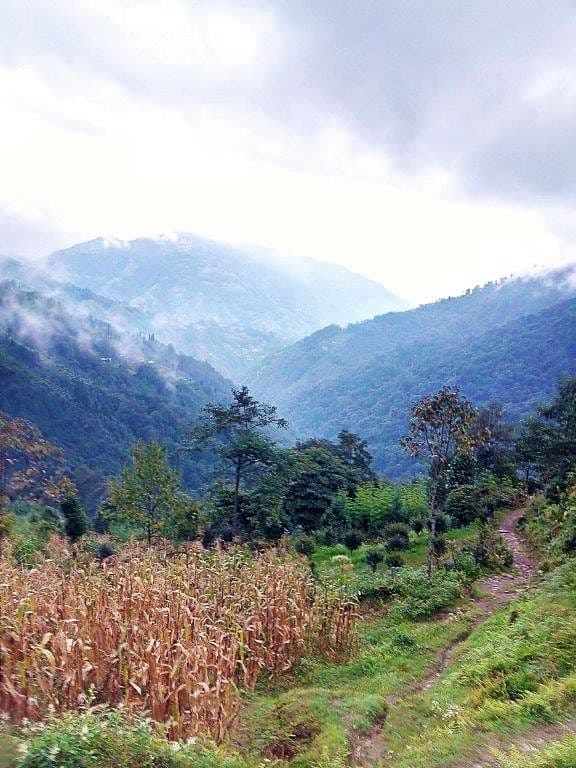
Sandakphu. Not far from the renowned hills of Darjeeling, in the northern mountains of West Bengal, precariously close and sometimes crossing the borders with Nepal, exists a pristine region of the eastern Himalayas.
Spread across West Bengal, Sikkim, and partly far-western Nepal, the Singalila Ridge stretches north to south, separating the ranges of Bengal from the other east-Himalayan ranges beyond. Enveloping this rolling mountainous ridge with untouched perennial greenery and sheltering some remarkable wildlife within, sits the Singalila National Park. The pinnacle of this forested ridge is Sandakphu.
Last Updated: March 2026
Let's quickly dive into the details:
What is Sandakphu and Why Should You Visit?
Sandakphu at 11,930 ft is the highest point in West Bengal and the summit of the Singalila Ridge. The name literally means “Peak of the poison plants,” attributed to the bloom of poisonous genus of plants nearby. One is the Aconitus, a perennial shrub whose roots have been used as medicine since time immemorial while its bright purplish-blue flowers and leaves can be lethally toxic if consumed carelessly. Another is the Himalayan Cobra Lilies which also abound the area.
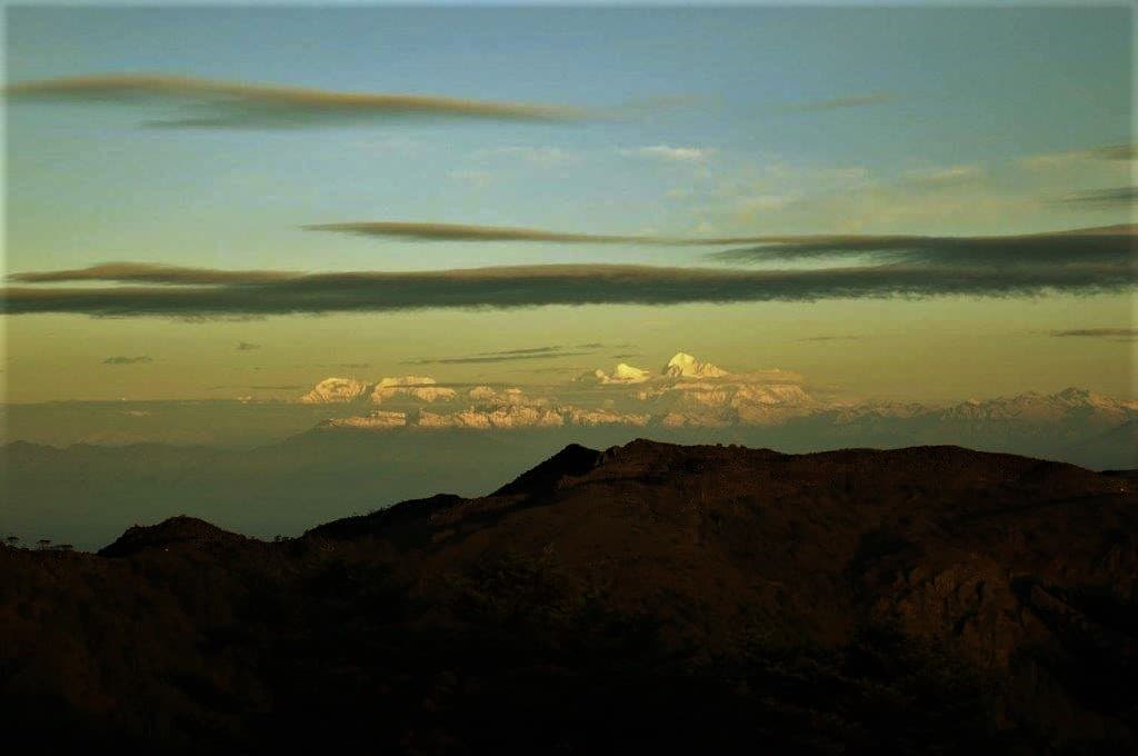
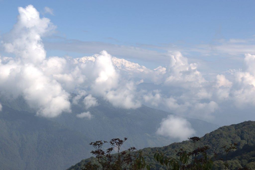
Sandakphu is a prominent name in the trekker’s world as a light-moderate trek. But what makes this small hamlet on top of a ridge a place not to miss in the eastern Himalayas is the fact that from here, on a clear morning at dawn, 4 out of the 5 highest peaks of the world can be seen as part of an extraordinary 180-degree panorama.
Apart from all five lofts of the Sleeping Buddha (Mt. Kanchenjunga, 28,169 feet, third highest), Mt. Everest (29,029 feet, highest), Lhotse (27,940 feet, fourth highest), and Makalu (27,838 feet, fifth highest) are visible sparkling spectacularly in the golden hue at sunrise. If you have ever dreamt of seeing Everest from India, Sandakphu is your answer.
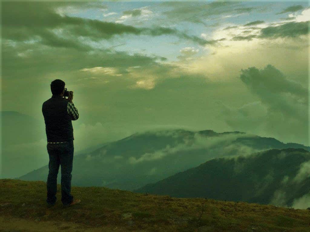
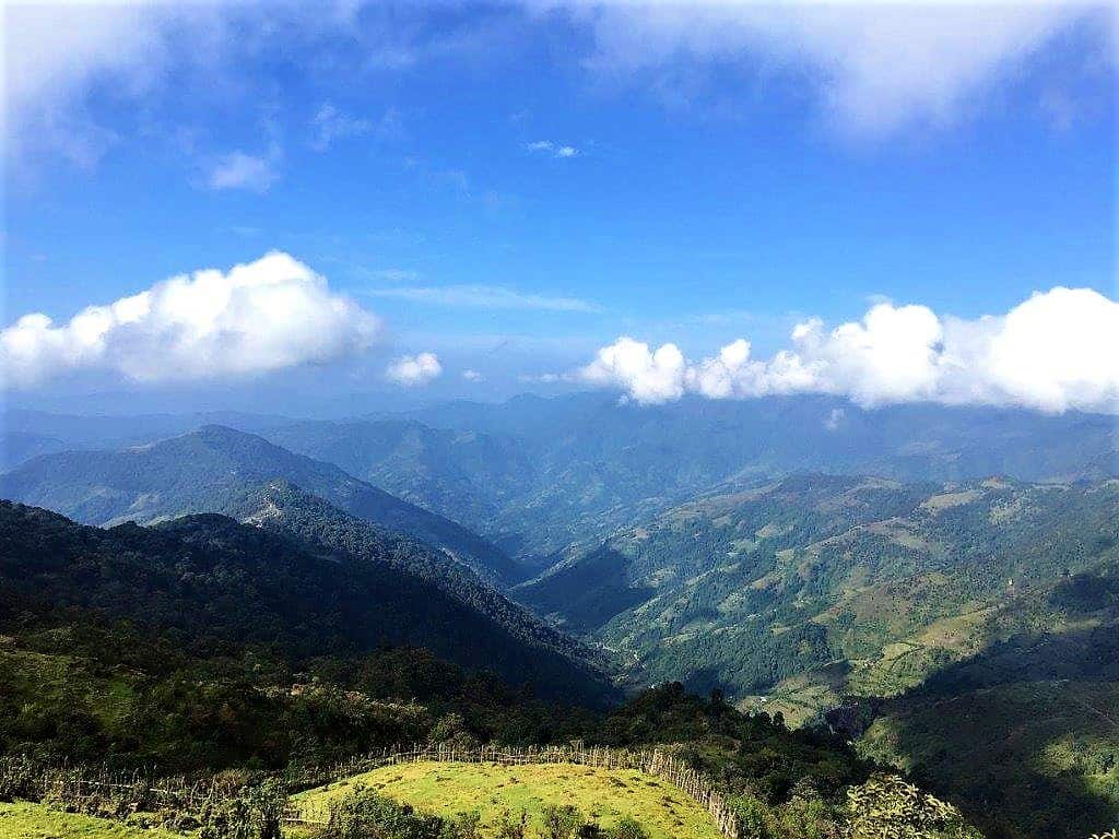
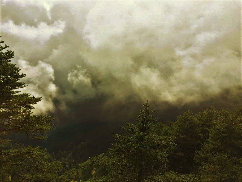
The view stretching from west to east consists of peaks from Nepal, Tibet, Sikkim, Bhutan, and as far as Arunachal. It is a humbling experience to witness the sunrise from here when the dazzle of bright red-pink-golden hues breaks apart the darkness, reflecting on the gigantic snowy mountains over waving clouds engulfing the valley below.
Sunsets are equally spectacular but generally, the views in the morning are clearer. There are separate sunrise and sunset points in Sandakphu for that matter.
How to Reach Sandakphu from Kolkata, Delhi, or NJP?
The gateway to the Singalila is the small town of Manebhanjan on the borders of India and Nepal, about 90 km from Siliguri, NJP, and Bagdogra. The route goes via Mirik and Sukhiapokhri and takes about 4 hours in a hired vehicle, available widely at both NJP Railway Station and Bagdogra Airport.
Another route to reach Manebhanjan is via the Hill Cart road that goes to Darjeeling. For this, take the road bifurcating left at Ghoom. NJP railhead is connected to all major towns of the country. Bagdogra has direct flights from Kolkata, New Delhi, Guwahati, Bangalore, Chennai, and Mumbai.
For people on a budget, shared vehicles to Mirik and Sukhiapokhri are available from the SNT stand at Siliguri. From both these places, shared jeeps to Manebhanjan are available but would take comparatively longer. As of 2026, a drop from Siliguri to Manebhanjan in a vehicle like Bolero or Sumo costs around Rs 3,000-3,500 and Rs 4,000-4,500 for Dhotrey. Srikhola to NJP in an exclusive vehicle costs around Rs 5,000-6,000.
Shared vehicles for Mirik and Sukhiapokhri are available from outside NJP and Siliguri stand in decent frequency. Shared vehicles for Srikhola, Rimbick, and Manebhanjan are also available from Siliguri stand but frequency can be as low as one single trip a day. Keep in mind, it is better to arrive at the stand early morning to secure your spot.
Is Trekking the Only Option to Get to Sandakphu?
No. It is motorable too. But there is a catch. It is not any smooth tarmac that anybody can drive on. The gravel-boulder track is tricky and only doable on a sturdy 4×4 SUV. Full of loose boulders, precarious bends, and steep ascents, it would also require exceptional driving skills to make it to Sandakphu without any serious damage to the vehicle.
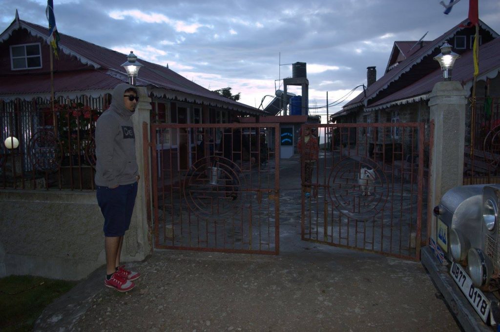
Old Land Rovers from the colonial days used to ply between Manebhanjan and Sandakphu, even till Phalut, taking tourists reluctant to trek to the top. However, they were banned by the local authorities in January 2018 on grounds of the vehicles being non-compliant with present norms of safety and environment. The West Bengal government subsidized the owners to buy Boleros instead to phase out the Land Rovers. As of 2026, Mahindra Boleros operated by the Singalila Land Rover Owners’ Welfare Association are the standard vehicles plying this route. The rates are fixed by the association, with Manebhanjan to Sandakphu round trip costing approximately Rs 4,800 plus Rs 1,000 per night for vehicle halt charges.
Earlier the entire 30+ km from Chitre (2 km up from Manebhanjan) to Sandakphu and onwards another 21 km to Phalut (second highest peak of the Singalila Ridge) was a boulder-gravel track. Presently the route has been paved partly with tarmac and partly with concrete for about 20 km from Manebhanjan till Gairibas. The last 12 km to Sandakphu and the 21 km from Sandakphu to Phalut remain unpaved.
Important: No bikes and no private vehicles are allowed to ply in the Singalila National Park area as of 2026. Only the association-registered Boleros/Land Rovers can operate on this route.
How Difficult is the Sandakphu Trek?
For an avid trekker, the Sandakphu trek would be easy to moderate. For absolute beginners too, it is quite manageable. To put it simply, if you are relatively fit and can walk 8-10 km in the plains with 2-3 breaks, you can make it.
Of course, the knees and calf muscles will hurt a bit, or one can take an occasional tumble, or twist an ankle, but then, that is part of the adventure. Countless beginners like myself have done it and hence been forever bitten by the bug of trekking more.
I feel Sandakphu can be an ideal trek for beginners for quite a few reasons:
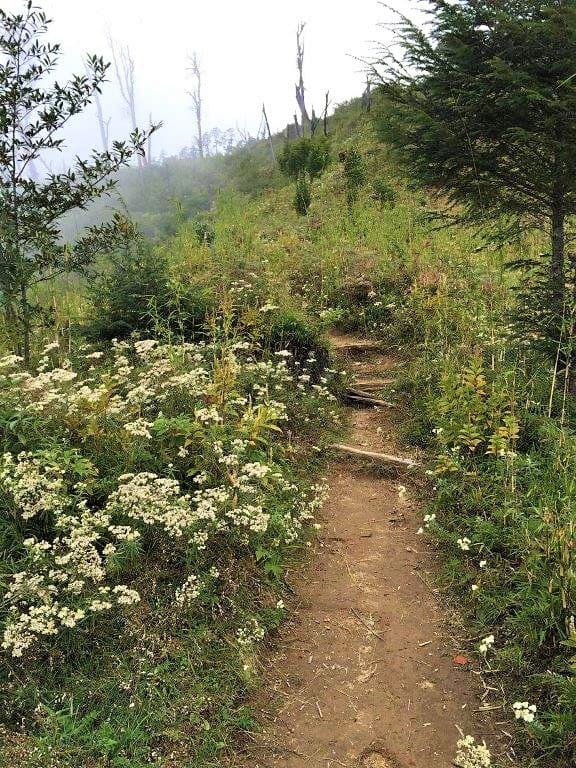
- The trail is well marked. The upward trek from Manebhanjan to Sandakphu almost entirely follows the boulder track used by the vehicles. There are enticing short cuts here and there but they are steeper, hence tougher.
- There are shops and settlements for refreshments almost every 2-3 km which helps with the tired legs to put down the backpack and sip a hot chai or a bowl of Maggi.
- Taking a guide is mandatory. The guides are trained for dealing with any kind of emergency that may arise during the hike. Porters are available too.
- The trek is not too easy, neither too difficult, so it gives beginners a real taste of trekking. The entire circuit takes 4-5 days to complete, which is perfect to get the actual drift.
- The places for overnight stays enroute are all permanent settlements with most of them having comfortable rooms and facilities. A good night’s sleep after a tiring day’s trek is invaluable.
- In the rare case of an emergency, if somebody is unable to walk further, the Boleros can be called for rescue, which is a unique advantage.
- Almost no trekking equipment or gear is required. Just a good pair of comfortable trekking shoes and you are good to go. The guides will cut you a walking stick from the woods which helps immensely. You can also check out our must-have trekking checklist for a comprehensive packing list.
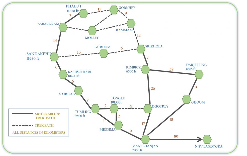
What is the Sandakphu Trek Route from Manebhanjan?
There are some alternate trek routes to Sandakphu apart from the most opted one, which is from Manebhanjan. The trek upward is 32 km from Manebhanjan to Sandakphu, which is covered commonly over 3 days. Experienced trekkers manage it in a day less. There happens to be a yearly race where trekking enthusiasts run to the top, like a Marathon. I have heard they cover the entire route in about 7-10 hours.
Manebhanjan (7,050 ft)
A non-descript little roadside hill-town, Manebhanjan is significant only perhaps as the gateway to the Singalila or more precisely Sandakphu. If you get out of NJP railway station in cargos, trekking shoes, and a rucksack, the over-enthusiastic drivers would ask you enquiringly, “Manebhanjan?”
The conventional trek starts from here. This is the place where one has to get an entry permit for the Singalila National Park. Also, the Highlander Guides and Porters Welfare Association is located bang on the bazaar, from where the mandatory guide and porters need to be hired.
The Bolero stand (earlier Land Rover stand) is just at the end of the market with a tariff board displayed for different places, the furthest being Phalut and the nearest being Tonglu or Tumling. The shops in the market sell and lend trekking gears like rain ponchos, boots, walking poles, etc.
Since this is the last bazaar of sorts, it is advisable to stock up on any last-minute necessities. Some guest houses and lodges are also present where trekkers stay for the first night before embarking upon the trek early next morning. The straight road goes up to Sandakphu and terminates in Phalut while another cuts right towards Dhotrey and subsequently Rimbick.
Dhotrey is an alternative starting point for the Sandakphu trek, which has gained popularity over the years owing to the fact that it cuts the trek down by 5 km. Also, the trail from here till Tonglu is through forests and greenery, unlike the one from Manebhanjan which is basically a cemented vehicular road.
Tonglu (10,070 ft)
At slightly more than 10,000 feet, Tonglu takes 6-7 hours to reach on foot. Now that the road is concreted, it should not even take an hour by vehicle for the 11 km from Manebhanjan. The trail at its beginning is quite steep till the quaint little settlement of Chitre, almost as if to make someone coming for his first major trek mull over the appropriateness of his decision right away.
Thankfully the ascent eases up after Chitre. 5 km further up from here lies Meghma on the borders of India and Nepal. From here onwards, you would be practically hopping across the borders many times over. There are no restrictions or any requirement for paperwork for this route. Meghma, as the name suggests, is often shrouded in clouds.
The trail bifurcates from here. The left goes from within Nepal to Tumling, while the one right remains domestic to reach Tonglu, before eventually meeting the other trail at Tumling.
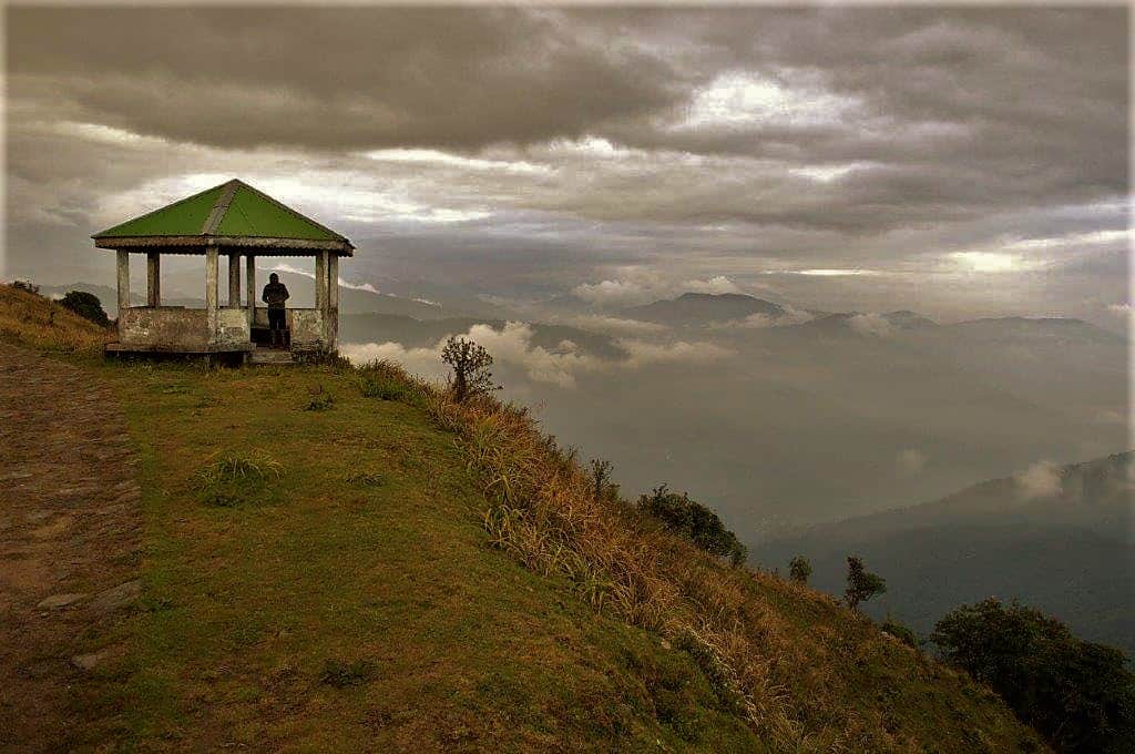
Tonglu is actually one of the high peaks of the Singalila Ridge, noted for its own sunrise spectacle over the Kanchenjunga. The hilltop is a small piece of flat land where the GTA (Gorkhaland Territorial Administration, erstwhile DGHC) has set up a charming Trekker’s Hut, as also at other places on the trail.
A DM’s bungalow and few other private lodges are all Tonglu is about. The views at any time from here are stunning. The clouds caressing the endless green mountain lofts as far as sight can reach. An aesthetically built viewing hut stands right at the edge, which adds charm to the setting. On a clear day, Darjeeling and the mighty Teesta meandering over the plains of north Bengal construct the view from Tonglu.
It gets quite windy and chilly at nights in Tonglu, even in the peak summer months. Tonglu is a preferred halt for the first night for trekkers.


Tumling (9,600 ft)
Geographically situated in the Ilam district of Nepal, Tumling at 9,600 feet is about a couple of kilometers downhill from Tonglu. It has better private stay options than Tonglu, which is slowly making this pleasant little hamlet a destination in itself, even for those who would not go till Sandakphu.
Now that the road has been paved, it is not surprising to see places like Tonglu and Tumling getting more popular with mainstream leisure tourists as well.
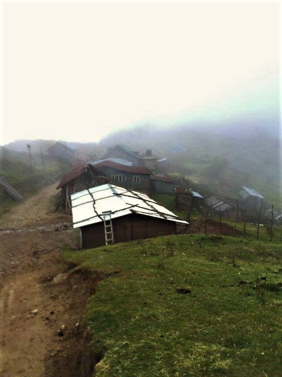
A small flat elevated piece of land almost in the middle of the little village of a handful brightly colored, sloping tin-roofed houses of the ethnic Gurungs of Nepal, serves as a viewpoint with a few park benches to sit and gaze at the heartwarming view of the Sleeping Buddha.
The Sandakphu peak can also be visible depending on the conditions. Few provision stores, most of them extended portions of homes, sell tea, Maggi, packaged water bottles, etc. Tumling was the last place on the trail to have got conventional electricity. However, even the other places supply solar power points to charge phones and devices at an additional cost.
The trail continues gradually downhill from Tumling all the way till Gairibas. A kilometer from here, an arched gate which reads “Singalila National Park” welcomes you.

The national park officially starts from here. The entry permits can be obtained from here too if you have missed acquiring it from Manebhanjan. Notably, for Tonglu or for that matter any place till Tumling, no permits or guides are required. It is only upon entering the Singalila National Park that they become necessary.
For non-trekkers, Tumling can be the place to spend the first night if you start before noon from NJP or Bagdogra.
What Wildlife Can You Spot in Singalila National Park?
The national park boasts rare flora and fauna. Eastern Himalayan sub-alpine and sub-tropical pines and conifers constitute the basic biome of the region. The entire trail passes through ageless Oak, Pine, Silver Fir, Birch, Magnolia, and several variants of Bamboo trees, besides more than 600 kinds of orchids, several variants of Primulas, Geranium, and Rhododendrons that add hue in the two blooming seasons.
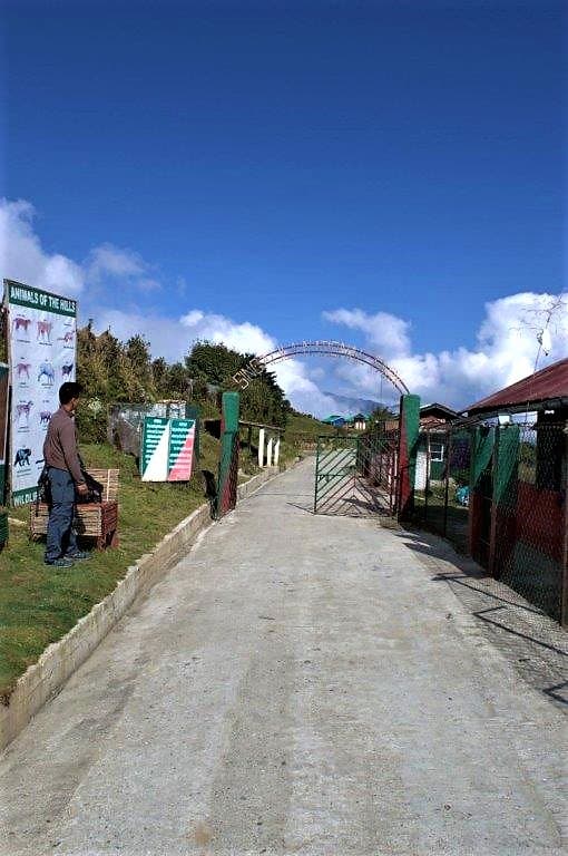
The fauna is equally diverse with endangered species like the Red Panda, Clouded Leopard, Himalayan Black Bear, Himalayan Barking Deer, and the Himalayan Newt apart from more than 120 recorded species of birds, which makes it a birder’s paradise too. If you are lucky, a Red Panda sighting on this trail is very much possible, especially in the sections between Tumling and Kalipokhari.
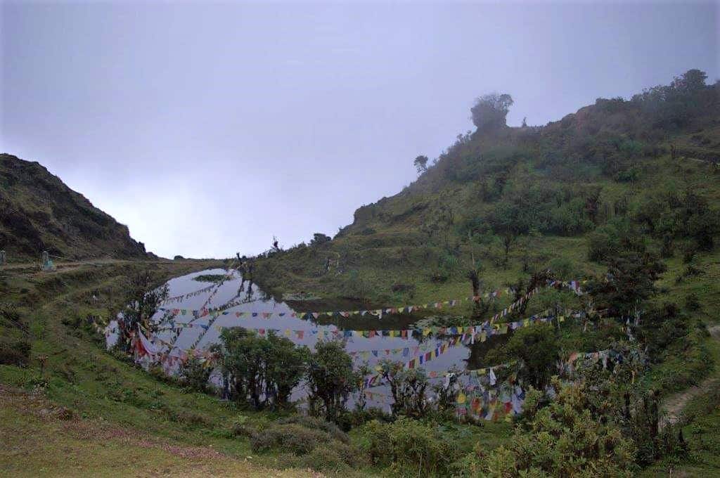
Kalipokhari a.k.a Kalpokhri (10,400 ft)
13 km from Tumling and 15 km from Tonglu, Kalipokhari at 10,400 feet is a day’s trek (7-8 hours). As the name indicates, the greatest feature of the place is a not too large lake containing black water. The locals say the water never freezes.
Buddhist prayer flags run crisscrossing over the lake, which appears as the first prominent landmark of the place, with the tin-roofed houses a little further. Some concrete sitting benches adorn the shores just by the side of the trail.
As one enters the Singalila National Park shortly after Tumling, the trail trifurcates. One goes from the Nepalese side through another small hamlet, Jhaubari. One goes gradually downhill to Gairibas from Indian territory, and this one has been concretized and taken by vehicles. Another slender trail, mostly through forested paths, also exists, which is a portion of the trek-only circuit made by the GTA in the early 2000s.
All three eventually meet at Gairibas (8,700 feet), which is gaining popularity since the road has been constructed, for its scenic location and a splendid trekker’s hut run by GTA on a delightful flat meadow. Some private accommodations have also come up in recent years.
The real ascent, however, begins from Gairibas. The 12 km till Sandakphu will test even the seasoned trekkers at moments. Kalipokhari is located almost equidistant from both Gairibas and Sandakphu, which makes it the most opted halt for the second night for trekkers.
There is no trekker’s hut here, however, the private lodges do the job offering similar services. The accommodation at Kalipokhari is perhaps the most basic one will find on the route, beside perhaps Phalut. If the day is clear, one can spot the famed Sherpa Chalet of Sandakphu from Kalipokhari.
For non-trekkers, Kalipokhari is just a stopover. They would ideally drive on till Sandakphu from Tumling, or even Manebhanjan.
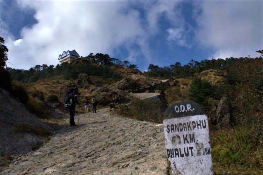
Sandakphu: The Final Ascent (11,930 ft)
The trek from Kalipokhari to Sandakphu may only be 6 km, but it is undisputedly the most excruciating of the entire stretch. Trekking above 10,000 feet is never easy. The air gets thinner which exhausts the hiker’s stamina easily, making it all the more difficult.
Out of Kalipokhari, the trail initially ascends gradually for the first 2 km till Bikheybhanjan, which is another tiny settlement of few huts and an SSB check post. One can stop and rest here briefly over a cup of tea before proceeding towards the steepest 4 km till Sandakphu.
The gradient of this final section, as if metaphorically illustrates the saying, “No great thing in life comes easy.” It is advisable to take small steps and frequent breaks. The last 4 km could easily take more than 2 hours to conquer. On the last bend before Sandakphu, a milestone reads, “SANDAKPHU 0 KM, PHALUT 21 KM,” when it is still another 400+ meters of a steep uphill walk from this point to the top.
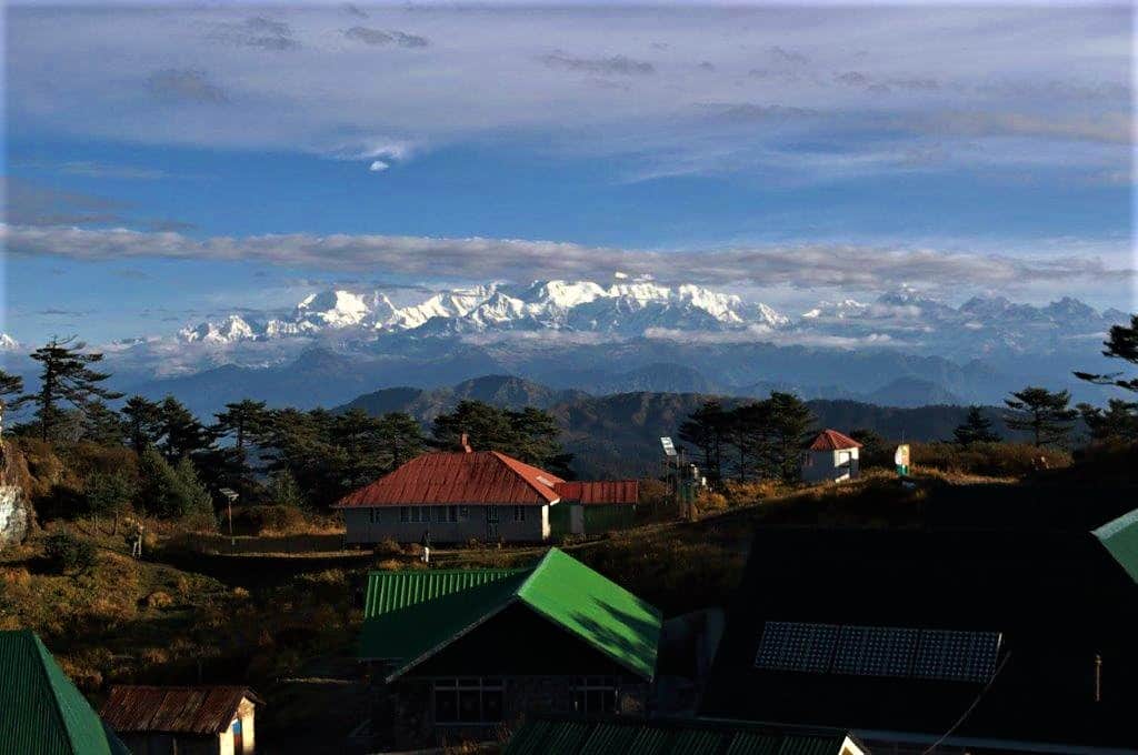
All the pain, all the exhaustion, will wither away once you reach Sandakphu, all the more if the view is clear by the time you reach (for which starting early from Kalipokhari is recommended). The graceful Sleeping Buddha will welcome you with a smile.
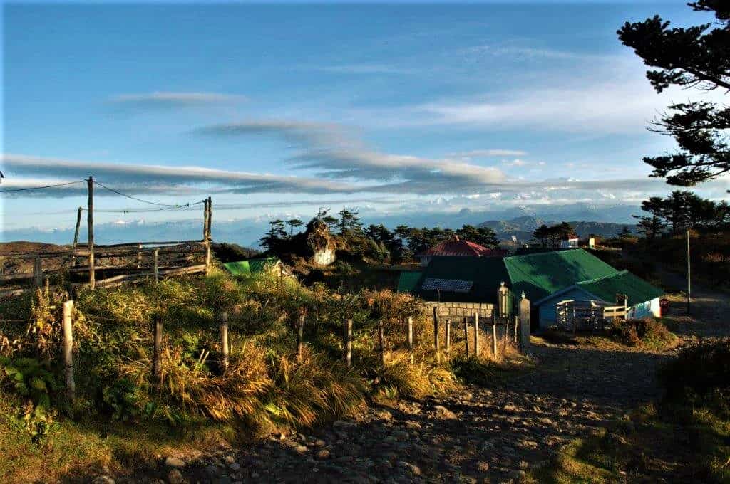
The brightly hued Hotel Sherpa Chalet is large and located right on the summit, making it visible even from the start of the day’s trek from Kalipokhari. There are a few other private properties beside it and some others including the GTA trekker’s hut slightly downhill.
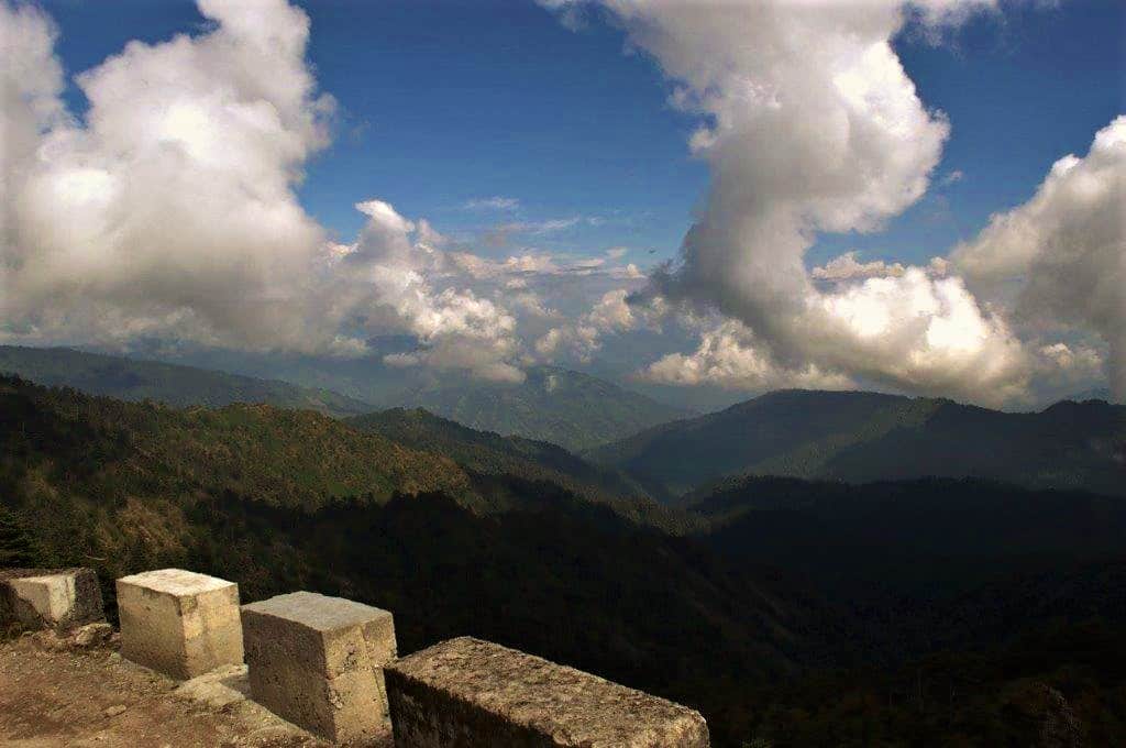
Besides the invigorating view, Sandakphu is magnificent in itself, dotted with tall standing evergreen pine conifers and rustic gravel paths. The breeze so pure, the skies bright blue, sprinkled pleasingly with abstract forms of free-flying radiant white clouds. Just grab a cup of hot chai and sit away the unhurried moments at Sandakphu.
What Can You See in the Panoramic Sunrise from Sandakphu?
Set the alarms right depending on the season and time of sunrise. The sunrise viewpoint is a 100 meters walk from Sherpa Chalet. As the darkness begins to give in, to welcome another new day, the mighty peaks start to glimmer in the first soft lights.
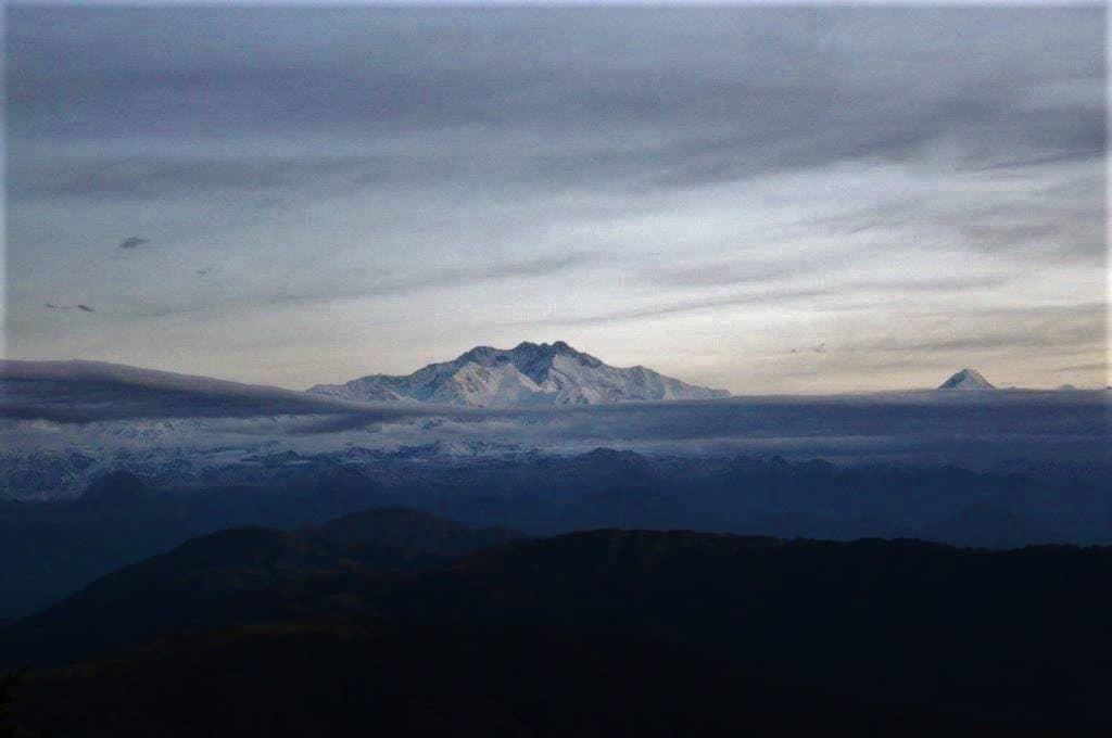
As it brightens up progressively, the westernmost object (leftmost in the view) on the 180-degree plane appears like a mammoth square wall of snow. This is Chamlang (24,000 feet). Just a little rightward from which appears the Titanic of all mountains of this planet, Mount Everest.
Lhotse and Makalu stand close by. Almost at the centrestage of the spectacle, poised in grand prominence is Mount Kanchenjunga along with her sister peaks. Between the Chomolungma (Tibetan name of Everest meaning mother of all mountains) and Kanchenjunga stands the “Three Sister Peaks,” named such probably due to their apparent similarity and clustered proximity.
Slightly right from the Sleeping Buddha, other prominent peaks of Sikkim like Kabru, Kumbhakarna, Simvo, Goeche, and Pandim are visible. Gaze rightward and even the distant Joguno and Narsing massifs of Tibet make an appearance. Chomolhari from Bhutan completes the panorama to the far right, unless the elusive Kangto of Arunachal Pradesh (23,165 feet) is visible, which is quite rare.
Sadly, however well I try to put it in words, words would remain mere words, futile and insignificant in justifying the reality, which has to be witnessed with one’s own pair of eyes to know what it actually looks like.
What are the Return Routes from Sandakphu?
Sandakphu to Phalut (21 km)
The gravel path goes on from Sandakphu till Phalut, the second highest peak of the Singalila Ridge at 11,810 feet. The distance is 21 km north of Sandakphu. Trekkers cover the distance in about 10-12 hours, mostly over an easier gradient.
There are no settlements enroute except Sabargram (a.k.a. Sabarkum), so it is imperative to carry supplies, especially water for the trek from Sandakphu. The Boleros take around 3 hours to reach. Another option to visit Phalut is on a day trip from Sandakphu, on the return of which one can stay back at Sandakphu or descend till Manebhanjan.
The route passes through picturesque vistas and for most of the journey, the Kanchenjunga keeps a watch on you. Some trekkers break for the day at Sabargram, which is 14 km from Sandakphu and has a forest hut to stay at, to complete the remaining 7 km the next day.
Phalut does not provide the wide-angle view that Sandakphu does, but the Kanchenjunga manifests itself in a more glorious way. The Sleeping Buddha seems closer from here.
It gets exceptionally windy at nights in Phalut, and to make it worse, it does not have as many options to stay, apart from a basic GTA Trekker’s Hut and few other private ones that have come up more recently. If planning for Phalut, ensure you get your stay pre-booked. On reaching there if luck runs out and you do not manage shelter for the night, the nearest other place will be quite far.
Some seasoned trekkers go on further from Phalut, crossing the Singalila Pass and ending the trek at Uttarey on the Sikkim side, which requires camping over 2-3 days. The famed Mainibas Waterfall occurs enroute.
Sandakphu to Srikhola via Gurdum (16 km)
From Sandakphu, the return has many variations. The obvious one is retracing the same way that took you up (Sandakphu to Kalipokhari to Gairibas to Tumling to Manebhanjan). But this one is rarely opted by trekkers coming down. If you wish to be driven down from Sandakphu, this will be the only option. Sometimes, people who trek up return in a vehicle or vice versa.
The most opted, shortest, and quickest way down is a 16 km downhill trek from Sandakphu to Srikhola via Gurdum. This enables the option of coming all the way down to a road-head in a single day. It is 10 km from Sandakphu to Gurdum and a further 6 km to Srikhola, which takes 4-5 hours and 2-3 hours respectively.
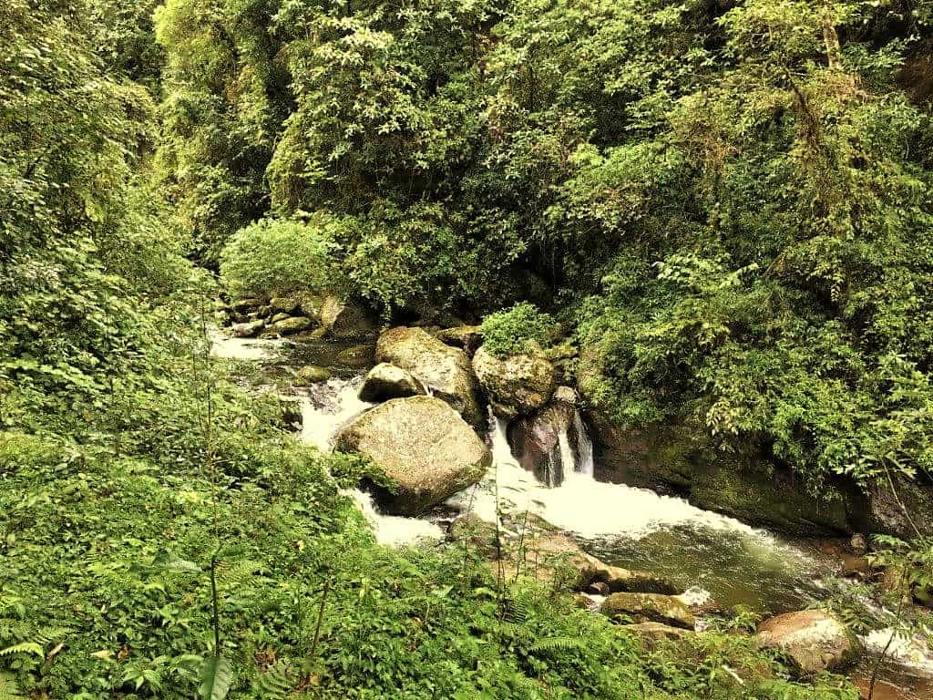
This trail is a pure trekking path through dense forests of the Singalila. Tracing almost entirely downhill, at places quite steeply, through pristine Oaks, Magnolias, Chestnut, and Bamboo groves besides colorful blooms of rhododendrons in April and May, this path is a refreshing relief after the rough boulder tracks up to Sandakphu.
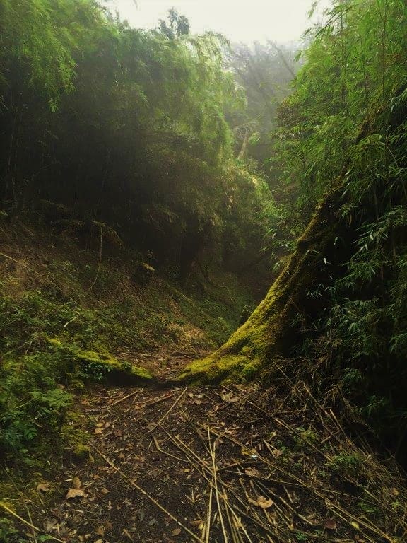
Narrow paths through the dense jungle, passing across meadows and waterfalls over rustic little footbridges, sometimes precariously over moss-laden tree roots and fallen trunks, watching over scenic green slopes diving into the valley. It is quite an adventure. If one is lucky, an encounter with a Red Panda or a Himalayan Bear cannot be ruled out.
Gurdum is an outlandishly picturesque little village with 7-8 houses squatted on a small flat-land carved on a steep slope. Dense evergreen trees all around, steeply diving valleys encircling a neat little hamlet of tastefully gardened houses.
An admirable family-run private lodge named Himalayan Sherpa provides lodging facilities. It might just be that upon arrival, one might feel inclined to spend a night there just attributing to its remarkable location. Otherwise spend a couple of hours over an early lunch and move on. Trekking on this route after dark is better avoided and hence an early start from Sandakphu is suggested.

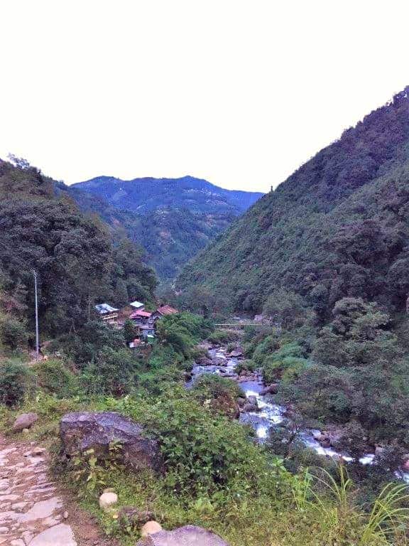
From Gurdum, initially the path descends rapidly till the gushing sounds of the flowing Srikhola can be heard below. Then it traces by the river for some distance before crossing it through a cemented footbridge over a splendid little bouncing waterfall amidst dense greenery.
Some accommodations have come up near this place (called upper-Srikhola) where the night can be spent or another 1.5-2 km of walk will take you to the main Srikhola village. Apart from a GTA trekker’s hut, few other private lodges and a somewhat upmarket riverside resort can play hosts for the night. Srikhola is another charming hamlet with a pleasant wooden bridge over the “khola” (meaning a small stream). If it is still daylight, the rocky course of the flowing stream has ample spots to spend the descending dusk over some hot chai.

Trekking downhill may not be as exhausting but it takes a toll on the knees and muscles of the lower leg. There may come a time in the course where the lower limbs may become somewhat numb. A good night’s rest in a warm bed is an essential remedy. Tip: Carry a can of pain relief spray.
A shared jeep leaves Srikhola at 7:30 in the morning for Darjeeling going via Rimbick, Dhotrey, Manebhanjan, and Ghoom. Another leaves at 11:30 for the same destination but through a route via Bijanbari. If you have the return train or flight on the same day from Siliguri, book your spots on the morning vehicle through the lodge owner the previous night.
A change of vehicle has to be done from Rimbick or Darjeeling for NJP or Siliguri. If the train or flight is sometime near afternoon then booking a full vehicle for an earlier start would become necessary as it will take between 5-6 hours for Srikhola to NJP or Bagdogra.
What are the Best Sandakphu Itineraries for 2026?
Sandakphu By Road (3-4 Days)
Day 1: Arrive at Siliguri, NJP, or Bagdogra and hire a car for Manebhanjan via Mirik. From Manebhanjan, hire a local 4WD Bolero from the stand for a drop till Tumling. Preferably, book the vehicle for the entire stay. Night halt charges for the vehicles are extra. Enroute stop briefly at Tonglu for a cup of tea. Overnight at Tumling.
Day 2: Start after breakfast from Tumling for Sandakphu. Enroute stop at Gairibas and Kalipokhari to enjoy the places. Overnight at Sandakphu.
Day 3/4: A place like Sandakphu deserves an additional day if possible. If staying back, take a day tour to Phalut and back. If returning, can go up to Phalut and descend straight for Manebhanjan thereafter, or drive down from Sandakphu itself. From Manebhanjan take another vehicle for Darjeeling or Mirik to change over again for Siliguri, or hire a full vehicle for Siliguri directly.
Sandakphu Trek Itinerary (4-5 Days)
Numerous nationally reputed trek aggregators besides many local ones conduct this trek. They include everything from entry permits, guides, porterage, accommodation, food, and transfers to and from Siliguri. However, a self-arranged trip can be managed with a little effort. One has to pre-book some places as per their itinerary, particularly in the months of rush, and reach Manebhanjan from where a guide can be booked instantly.
Day 1: Arrive at Siliguri, NJP, or Bagdogra and hire a car for Manebhanjan via Mirik. Hire a guide and porters as per requirements. If wishing to start the trek from Manebhanjan, stay overnight and start early next morning. Alternatively, now that the road has been paved, hire a vehicle for Tonglu or Tumling and start trekking onwards on Day 2. This will save one day and cut down 13 km of the trek. Another option is to drive 17 km past Manebhanjan till Dhotrey and start the trek from here through the Dhotrey-Tonglu forest trail.
Day 2: If starting from Manebhanjan, trek uphill till Tonglu or Tumling and stay overnight. If commencing the trek from Tumling, trek up to Kalipokhari or Gairibas.
Day 3: Start early from Kalipokhari for Sandakphu. Take it slow especially after Bikheybhanjan. Overnight at Sandakphu.
Day 4: If trekking all the way up from Manebhanjan, you will reach Sandakphu today. If already here, start the trek for Srikhola via Gurdum. Stay overnight at Gurdum if there is an additional day, or else at Srikhola.
Day 5: Take one of the two daily service jeeps from Srikhola for Darjeeling. Change either at Rimbick, Manebhanjan, or Darjeeling for NJP, or alternatively hire a vehicle directly for NJP.
Phalut Trek from Sandakphu and Return (7-8 Days)
Day 1-4: Same as Sandakphu trek discussed above.
Day 5: Trek the 21 km from Sandakphu to Phalut which will take 8-10 hours. Overnight at Phalut.
Day 6: Trek Phalut to Gorkhey and stay overnight (one of the most beautiful villages of the Singalila, beside a khola). The 15 km trek takes 6-7 hours for the average trekker.
Day 7: Trek Gorkhey to Srikhola via Rammam. Overnight at Srikhola.
Day 8: Take one of the two daily service jeeps from Srikhola for Darjeeling.
When is the Best Time to Visit Sandakphu?
The Singalila National Park is officially closed during monsoons from mid-June to mid-September. A trip to Sandakphu can be done anytime in the remaining months. However, the months of March to May and October to December are considered the best periods to visit.
The spring months (March to May) are when the Rhododendrons bloom and make the region wear a multitude of colors. This is personally my favorite time for the trek. The winters (October to December) are known for unhindered clear views of the peaks and the autumn bloom of orchids and primulas. The snowing months of January and February are also getting popular for the unique experience of trekking over snow, but for which proper snow boots and jackets become necessary.
Even in summers, Sandakphu can get chillingly cold and windy particularly at night. Carrying heavy woolens, thermals, hand gloves, and head covers is recommended regardless of the season. Keep in mind, temperatures can drop to near freezing even in April at the summit.
Where to Stay and What Does It Cost?
GTA Trekker’s Huts and Lodges are located at Tonglu, Gairibas, Kalipokhari, Sandakphu, Phalut, and Srikhola. They are quite affordable and provide basic facilities with common toilets. A bed in the dormitories costs around Rs 300-500 per night as of 2026. GTA has offices in Kolkata and Darjeeling from where bookings can be made.
Information centers are available at Kalimpong and Siliguri. GTA also conducts organized treks for Sandakphu and Phalut. Details can be found at their website. However, online booking facilities are still limited.
G.T.A., Darjeeling
Secretariat Office, Lalkoti, Darjeeling.
Email: edtourismgta@yahoo.in
Website: www.gtatourism.com
Phone: (0354) 2255022
G.T.A., Kolkata
Gorkha Bhavan, Salt Lake (Opposite CityCentre Mall).
Block: DD-28, Sector 1, Salt Lake City, Kolkata – 700064.
Phone: 9903174047, (033) 23377534
Recommended Private Accommodations and Contacts
As the region is gaining popularity, more so after the vehicular road has been revamped, new homestays and lodges are opening up. Some recommended properties along with their contact details are listed below. Since connectivity is erratic in these parts, keep trying the numbers over a few days or shoot an SMS for better chances of getting through. The tariffs of most are generally in the range of Rs 1,000-2,000 for a standard double room as of 2026.
- Hotel Sherpa Chalet, Sandakphu (Best in Sandakphu): 8509252318 / 9742621760 / 9933488159
- Pandim Lodge, Kalipokhari: 9333964774 / 9735916541
- Shikhar Lodge, Tumling (Personal favorite): 9564797551 / 91488 24227
- Magnolia Lodge, Gairibas: 91 76021 68750
- Himalayan Sherpa Lodge, Gurdum: 9733361799
- Jiban Chetri’s Exotica Lodge, Manebhanjan: 9733044512. Popularly known as Master ji, can help in arranging everything for the trek and also to book the GTA properties.
- Hotel Shovraj, Srikhola (Upmarket riverside resort): 09933488243
- Goparma Lodge, Srikhola: 9818827720
- Sherpa Lodge, Dhotrey: 9476386379
- Nagen is a local registered and trained guide from Manebhanjan: 8906202755. He can also arrange for every requirement.
- Highlander Guides and Porters Welfare Association, Manebhanjan: 9734056944 / 9933369449 / 9476151523
There are no proper restaurants on the entire route apart from maybe some non-descript eateries in Manebhanjan. Throughout the route, small tea shacks cater to travelers with basic items like omelettes, Maggi, tea, etc. Sometimes they also have dal-chawal. The places one would stay provide basic meals at additional cost. The cost of food rises with altitude. Sandakphu is the most expensive where a basic thali would cost around Rs 200-300.
What Permits and Guides Do You Need for the Sandakphu Trek?
An entry permit for Singalila National Park is mandatory. As of 2026, the cost is Rs 200 per person for Indian citizens and Rs 500 for foreign nationals (updated from the earlier Rs 100/Rs 200). Additionally, camera fee of Rs 100 for still digital cameras and Rs 400 for video cameras applies. The entry permits can be obtained either at Manebhanjan or at the entry gate of the park shortly after Tumling.
Visiting Tonglu, Tumling, and Srikhola independently does not require any permits.
Taking one guide per group is mandatory and can be hired from the Highlander Guides and Porters Welfare Association outlet at Manebhanjan. They are also available from Dhotrey and Srikhola (in case of a reverse trek). As of 2026, charges are approximately Rs 1,500-2,000 per guide per day and Rs 800-1,000 per porter per day, which includes their stay and food for the entire stretch except at Sandakphu where the food expenses need to be borne separately. These rates have increased significantly from earlier years, so do verify the latest rates at the association counter.
What About Mobile Network, ATMs, and Other Utilities?
There are no ATMs on the route, even none at Manebhanjan. The closest is a sole SBI ATM at Sukhiapokhri. Mirik has 3-4 ATMs besides many at Siliguri. Carry all your required cash from these places. UPI payments are not available on the trail.
Manebhanjan has a health center and the nearest hospital is in Darjeeling. Same goes for police stations with Manebhanjan having an outpost. Being on the borders there are several SSB camps and checkposts enroute.
As of 2026, Jio and Airtel work intermittently at Manebhanjan and Srikhola. BSNL has slightly wider coverage but the network strength is undependable throughout the trail. After Tumling, expect very limited or no connectivity. Many locals use Nepali SIM connections which work better in the border areas.
After Tumling, there is limited conventional electricity, though the lodges have installed solar panels for minimal lighting purposes and charge their guests’ phones and cameras at a marginal extra cost ranging from Rs 20-50 per device. Candles are provided by the hosts, which add to a primordial experience of being unconnected and immersed in the rawness of the place.
Sandakphu Trek Budget Breakdown for 2026
Here is a rough budget breakdown for a 5-day Sandakphu trek from NJP or Bagdogra for an Indian traveler, per person (assuming a group of 2-4):
| Expense | Budget (Per Person) |
|---|---|
| NJP/Bagdogra to Manebhanjan (shared) | Rs 400-600 |
| Singalila National Park Entry Permit | Rs 200 |
| Camera Fee (Still) | Rs 100 |
| Guide (Rs 1,500-2,000/day shared among group, 4 days) | Rs 1,500-4,000 |
| Porter (optional, Rs 800-1,000/day, 4 days) | Rs 800-2,000 |
| Accommodation (4 nights, Rs 300-1,500/night) | Rs 1,200-6,000 |
| Food (4 days, Rs 300-500/day) | Rs 1,200-2,000 |
| Srikhola to NJP (shared) | Rs 400-800 |
| Total (Budget to Comfortable) | Rs 5,900-15,700 |
Trek operators charge Rs 8,000-15,000 per person for an all-inclusive package (transport, accommodation, food, guide, permits). This can be a good option if you prefer a hassle-free experience. For those doing it independently, the budget end of the above table is very achievable. Keep in mind, these are approximate figures as of 2026. Verify the latest rates at Manebhanjan.
Conclusion
Singalila presents a unique opportunity for travelers to get a feel of a sub-alpine national park situated on a Himalayan ridge. It has something for everyone. Be it photography, bird-watching, trekking, wildlife spotting, or just leisure traveling through the serene slopes and valleys of the eastern Himalayan mountains.
The cherry on top, a view which is unparalleled and shall remain engraved in the memories of the beholder. Sandakphu made me realize that if mountains are to be truly observed, it cannot be done just by traveling on metalled roads in a car on a point-to-point sightseeing basis. They have to be walked upon and hiked. Only then their true treasures unfold.
If you are planning a larger eastern Himalayan trip, do check out our guides to Zuluk in East Sikkim, Pelling in West Sikkim, and the beautiful Old Silk Route. For more beginner-friendly treks across the Himalayas, our list of easy treks in Uttarakhand might interest you as well.
For other details about traveling on this adventure trip, discussions, queries, finding travel partners, please go through the DwD Community. Feel free to ask any questions in the comments section below and I will be happy to help 🙂 …
Frequently Asked Questions
Can beginners do the Sandakphu trek?
Yes, the Sandakphu trek is considered easy to moderate and is one of the best beginner treks in India. The trail is well-marked, settlements with refreshment stops appear every 2-3 km, guides are mandatory (and trained for emergencies), and accommodation is available at permanent settlements along the way. If you can walk 8-10 km comfortably in the plains, you can manage this trek.

How much does the Sandakphu trek cost in 2026?
A self-arranged Sandakphu trek costs approximately Rs 5,900-15,700 per person depending on your accommodation choices and group size. All-inclusive packages from trek operators cost Rs 8,000-15,000 per person. The park entry permit is Rs 200 for Indians and Rs 500 for foreigners.
Is it possible to reach Sandakphu by car?
Private vehicles are not allowed inside Singalila National Park. However, you can hire the association-registered Mahindra Boleros (which replaced the iconic Land Rovers in 2018) from Manebhanjan. The round trip costs approximately Rs 4,800 plus Rs 1,000 per night for vehicle halt. The road is paved till Gairibas but the last 12 km to Sandakphu is rough gravel track.
What is the Sleeping Buddha view from Sandakphu?
The “Sleeping Buddha” is the shape formed by the Kanchenjunga range of peaks when viewed from Sandakphu. The mountain range resembles the figure of Lord Buddha lying in peaceful sleep. It is one of the most iconic mountain views in India. On a clear morning, you can see Everest, Lhotse, Makalu, and Kanchenjunga, which are 4 of the 5 highest peaks in the world, in a single 180-degree panorama.
Do I need a permit for the Sandakphu trek?
Yes, an entry permit for Singalila National Park is mandatory. As of 2026, it costs Rs 200 per person for Indians and Rs 500 for foreigners, plus camera fees. The permit can be obtained at Manebhanjan or at the park gate after Tumling. A mandatory guide must also be hired from the Highlander Guides and Porters Welfare Association at Manebhanjan.
Is there mobile network on the Sandakphu trek?
Mobile network is unreliable on most of the trail. Jio and Airtel work intermittently at Manebhanjan and Srikhola. After Tumling, expect very limited or no connectivity. There is no conventional electricity after Tumling either, though lodges offer solar charging for Rs 20-50 per device. Carry a power bank and inform your family that you will be unreachable for 3-4 days.
When is Sandakphu open for trekking?
Sandakphu is open for trekking from mid-September to mid-June. The Singalila National Park is officially closed during monsoons (mid-June to mid-September). The best months are March to May (rhododendron blooms) and October to December (clear mountain views). January and February offer snow trekking but require proper gear.
8 Comments
Comments section gets closed in 90 days. To ask your travel questions, you can follow my YouTube Channel for a faster reply or for a much slower reply follow me on Instagram. :)
Is there any other accommodation (private) other than GTA trekkers hut in tonglu? Can you please provide the names and phone numbers?
Thank you for sharing the experience… Just wanted to know if travelling with kids is worthwhile to Sandakphu may be in a jeep and can the reservation be made before handed to the place?
Hi Sunrit,
Great article! I have been searching for information on Sandakphu hike for a month now and your article by far covers it the best. Very well written. I am visiting Darjeeling in May 2019 with family and I am trying to see if I could fit a Sandakphu hike in my itinerary. I have been hiking and backpacking for a while now and I believe I can get to Sandakphu from Mane in 2 days. What I can’t figure out is the fastest way to get to Bagdogra Aiport from Sandakphu. Here’s the itinerary which I am thinking about:
Day 1: Mane to Gairibas
Overnight stay at Gairibas
Day 2: Gairibas to Sandakphu
Overnight stay at Sandakphu
Day 3: Sandakphu to Bagdogra by around 10 am.
I want to book the 12:20pm flight from Bagdogra to Mumbai on Day 3 but I am not sure if I can make it on time. When I google it, the map shows me a route from Sandakphu to Bagdogra via Nayabazar – Jaubari road which bypasses Mane and gets to the airport in 3h 10 min.
Here are my questions to you and I would really appreciate your feedback:
– Can I reserve a Jeep/SUV which will take me from Sankaphu to Bagdogra airport?
– Does the route which I mentioned above exists?
– If not, what do you think is the fastest route to Bagdogra airport from Sandakphu.
– Is there an alternate itinerary you can suggest which can get me to Bagdogra airport in time for the 12:20 pm flight on Day 3 [which also involves some hiking and not just driving in the SUV :)]?
This is Quite a long post and You shared your travel experience, I always Think East Part of India, But Never got any chance, I always wonder only Goa is the best holiday destination but when I came across your article, what I was really missing. Thank you for sharing, Now I need to add Sandakphu in my bucket list
wow…amazing thank you so much. loved with these photos
Thank you for pointing out. Indeed many people have rode their bikes till Sandakphu. I’ll edit he article.
Sunrit, In the latest rules someone posted in DwD Community group, now bikes are banned and only Land Rovers are allowed. Even private vehicles are no longer allowed.
Two options are mentioned in article …trek and 4×4…. But many have ridden there on bike also….So two wheeler is third option also.
https://discoverwithdheeraj.com/forums/topic/s-3-sandakphu-sikkim-sohra-on-bike/page/6/#post-52798