
Last Updated: February 2026
Have you heard about the Shyok Village route in Ladakh and wondered what it is really like to drive through it? Back in 2012, this route between Pangong Tso and Nubra Valley was one of the most isolated and adventurous stretches in all of Ladakh. No paved roads, no help for miles, and the Shyok river flowing right across the road at multiple points. I drove it with my friends Himanshu and our local driver Rigzin, and it turned out to be one of the most memorable days of my entire Ladakh journey. Let me take you through that adventure, and also share what has changed on this route since then.
What Is the Shyok Village Route in Ladakh?
The Shyok Village route is the direct road connecting Pangong Tso (via Durbuk and Tangste) to Nubra Valley (via Agham). It runs along the Shyok river for a large stretch and passes through the remote Shyok village. The alternative to this route is the longer Wari La route, which adds about 70 km and 3.5 to 4 hours of extra driving. In 2012, the Shyok route was in tatters, almost undrivable in July and August when snowmelt swelled the river. Today, thanks to BRO’s continuous work on the Darbuk – Shyok – DBO road, the situation has changed significantly. But more on that later.
Quick Facts: Shyok Village Route
| Detail | Information |
|---|---|
| Route | Tangste – Durbuk – Shyok Village – Agham – Nubra Valley |
| Distance | Approximately 160 km (Diskit to Pangong via Shyok) |
| Drive Time | 5-6 hours (as of 2026, roads improved) |
| Altitude Range | 10,000 – 14,000 Ft |
| Best Time | June, September, early October |
| Avoid | Late July to August (river flooding risk) |
| Permit Required | Inner Line Permit (ILP) for Nubra + Pangong |
| Fuel | No fuel pumps on this stretch. Carry extra. |
| Mobile Network | Jio and Airtel postpaid work near villages (as of 2026) |
How Did Our Shyok Village Adventure Begin?
This was Day 6 of my Ladakh trip in 2012. If you have been following the journey, here are the previous parts of the travelogue:
- My Never Ending Journey to Ladakh
- Sham Valley – Nature, Monasteries and More
- Stakna, Hemis and Chumathang Hot Springs
- Magical Colours of Tso Moriri
- Hanle – The Cold Desert in Changthang
- Remoteness of Changthang
- Blue Hues of Pangong Tso
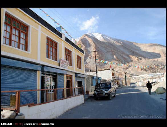
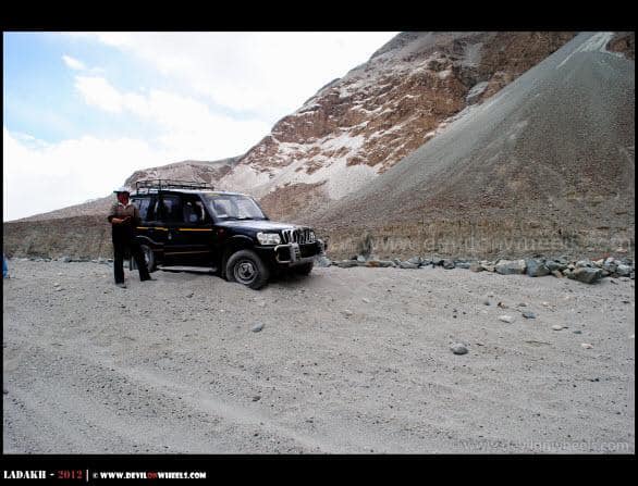
I woke up early in the morning with lots of excitement inside, imagining the adventures of the route from Pangong Tso to Nubra Valley via Shyok Village which we planned to cover today. Got myself ready, asked others to wake up and by 7 AM we were all set to go downstairs for breakfast at the Yakmik Changla Guest House in Tangste. We had to leave early because there was a real possibility that we might have to come back in case the route was closed somewhere. That would have meant tracking all the way back to Chang La and then to Leh. The lady had cooked nice omelette and paranthas which we gulped within no time. All set, prayers to god, off we went into the unknown.
What Is the Route from Tangste to Shyok Village?
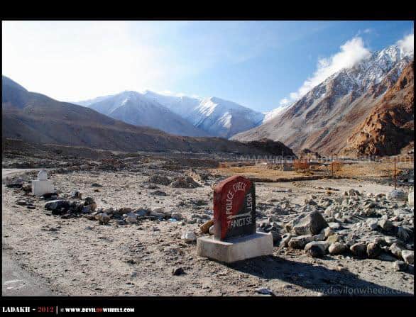
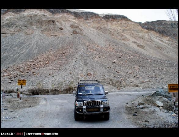
Rigzin stopped at the police checkpost of Tangste where we submitted the permits to go ahead. Durbuk is the key junction on this route. If you are coming from Pangong Tso side, you need to take a right turn at Durbuk to move towards Shyok Village and further into Nubra Valley. The left turn follows the route to Chang La, from where you can either go to Leh or take the Shakti – Wari La route to Nubra Valley, which is quite longer. There is almost a difference of 70 km between the Wari La route and the Shyok Village route, meaning about 3.5 to 4 hours less of travel if you take the Shyok route.
We were ready to take the chance, but keep in mind that both these routes in 2012 were extremely isolated. Help would have been very difficult to get in case of any eventuality. The Shyok Village route was in tatters and almost impossible to cross in July and August when snow melts rapidly. You literally had to cross the deadly Shyok river at times as it flowed right across the road. We were ready for that gamble, and with fingers crossed, we entered the unknown territory. Even our local driver Rigzin had not driven this stretch before 🙂
For those planning this route today, I suggest reading my detailed guide on the Nubra Valley to Pangong Tso direct route which covers the latest road conditions and practical tips.
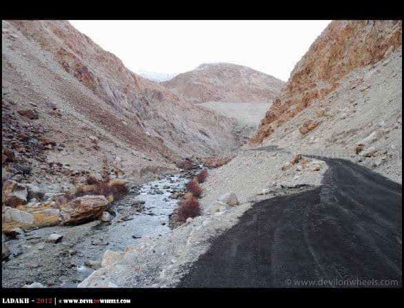
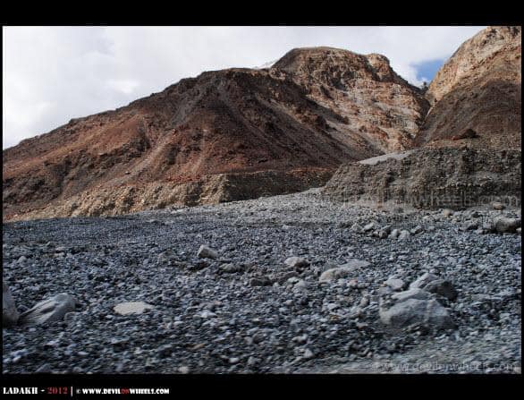
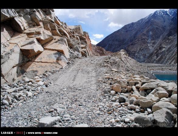
What Were the Road Conditions Like on the Shyok Route in 2012?
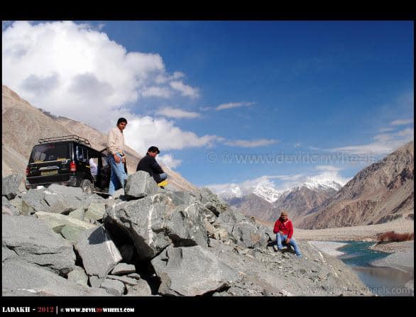
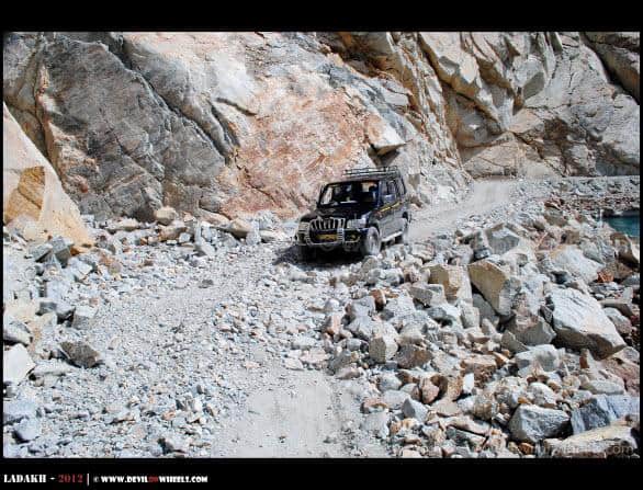
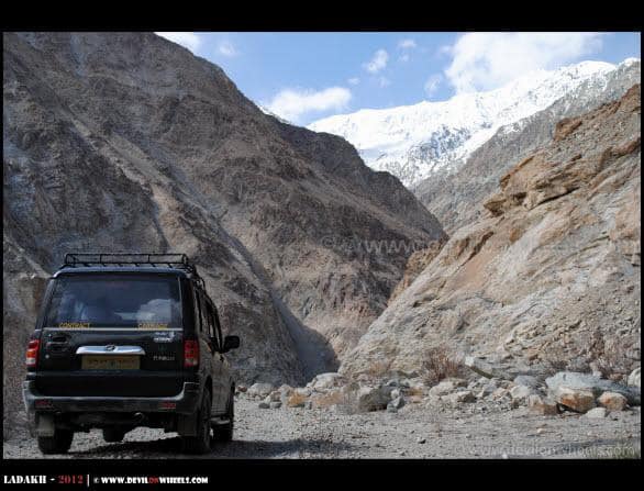
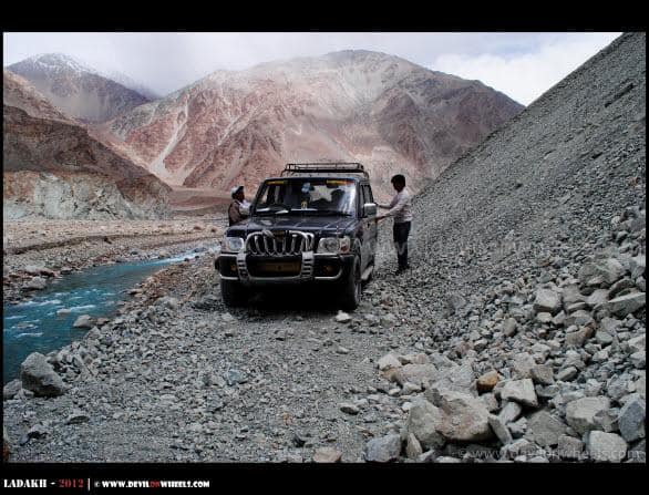
Rigzin was quite slow as we moved deeper and deeper into the unknown terrain. The vistas were magnificent, a bit different from what we had been seeing within Changthang for the last three days. The views were like paintings done by a world class artist using all his favourite colors 🙂 … At one point, we were running close to the Shyok river and soon we gained tremendous altitude. It was getting a bit scary and then we had a quite large bump to cross, even large for a Scorpio that it touched the foot base. Slowly, Rigzin negotiated it and we were almost at the top, looking at the great Himalayan peaks on the other side of the valley from eye level.
We stopped there for a while but since the sun was rising from that direction, we could not capture it well in the camera though we took lots of pictures of ourselves. No one was behind us, no one was ahead of us. We were completely alone.
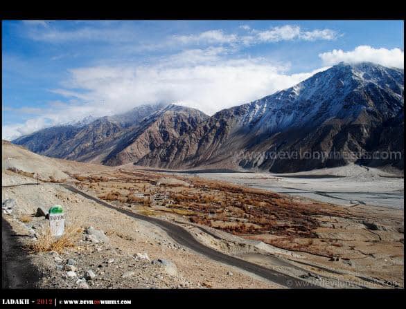
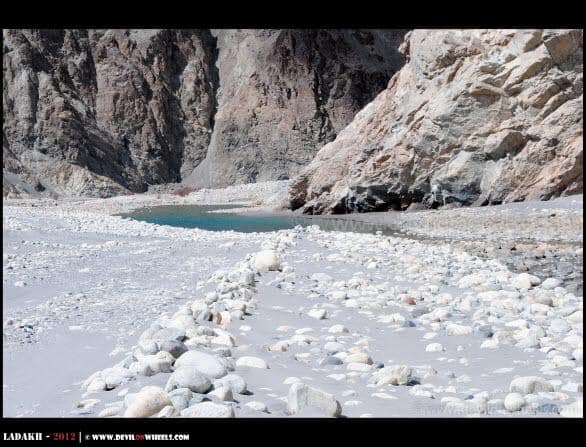
How Beautiful Is Shyok Village?
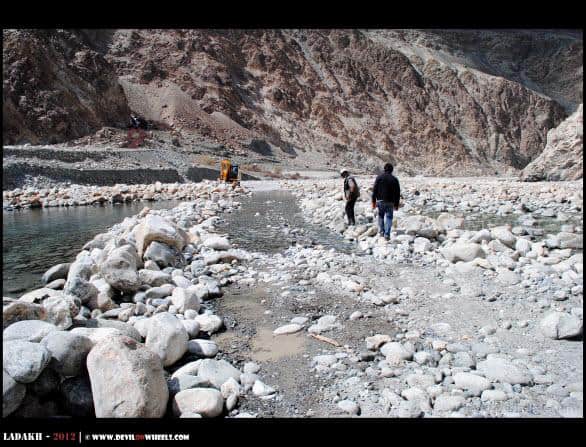
Soon we reached the beautiful Shyok Village, and honestly, no words can describe the beauty. Even the pictures below do not do any justice at all. A camper there told us that a few landslides were cleared the previous night and if we drove cautiously, we would be able to pass through the route into Nubra Valley. It was a sigh of relief and we had full faith in Rigzin to get us through.
There is a route near Shyok village that goes to Daulat Beig Oldie (DBO), a military base which is the northernmost built-up area in India after Siachen Glacier military bases. DBO sits about 9 km short of the Aksai Chin Line of Actual Control between China and India, and temperatures here drop as low as -30 degree Celsius. As of 2026, BRO is also building an alternative route to DBO which is expected to become operational by late 2026, reducing the travel time from Leh to DBO significantly.
What Kind of Adventures Did We Face on the Shyok Route?
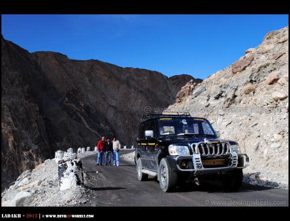
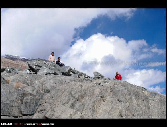
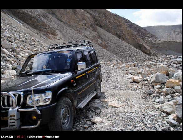
We continued and there came a point where I could not resist stopping amidst the rocks. It was super fun sitting there taking pictures and seeing the courage of Rigzin who kept us laughing with his jokes. We were told by that villager about a GREF hut ahead from where we could inquire about the conditions, because there were lots of rocks present on the road. The Captain there said they had cleared the road the previous night, warned us to be cautious, and let us go ahead.


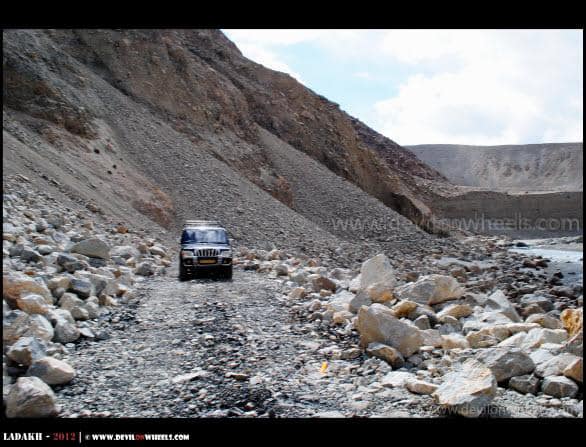
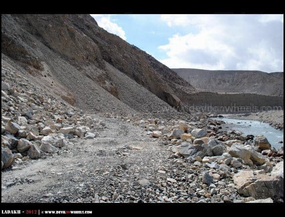
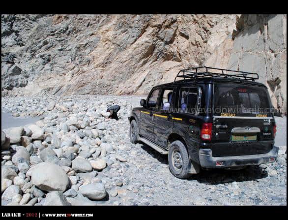
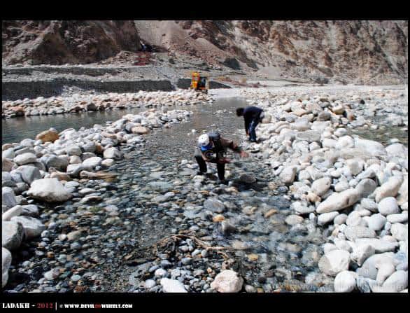
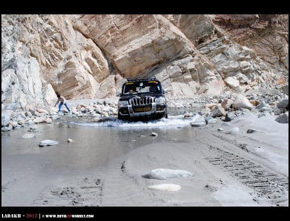
It was such a photogenic spot that it looked as if a rock had been placed right there just for taking pictures. Good opportunity for Himanshu to get some nice matrimonial snaps 🙂 … As we moved ahead, the road deteriorated badly. It felt as if we were running on a river bed, and it was indeed a river bed. Extremely bad and dangerous, with the Shyok river flowing right alongside. At places we had to get out, clear the rocks in front, make our way, and then move ahead. Finally, there was water all over the road, a part of the river was flowing on the road itself.
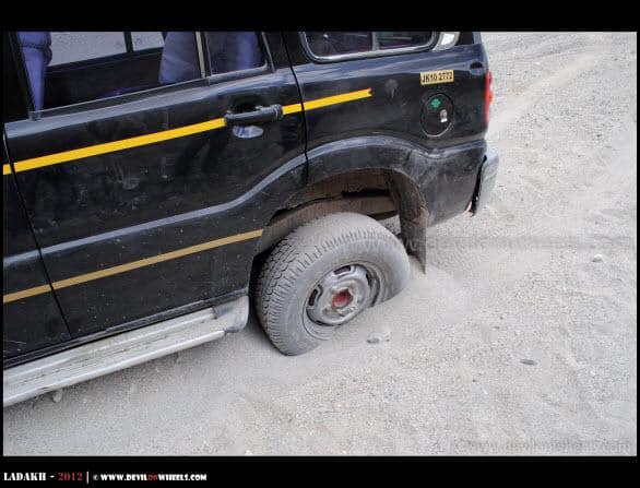
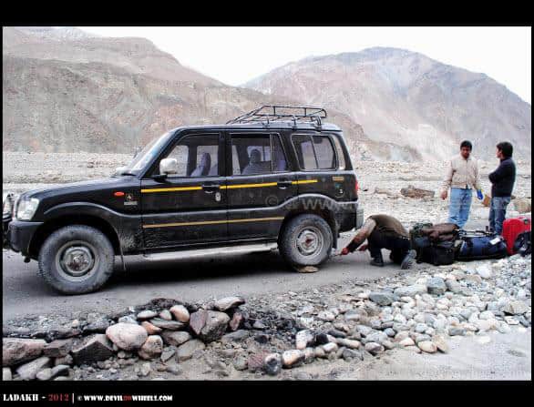
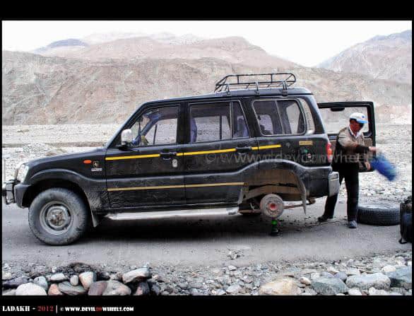
This was the real adventure. We never knew what lay ahead for us. We got out, checked the water level as Rigzin planned the exit path, and I took position to get some pictures out of it. We managed, but it punctured the rear tyre. We kept moving since there was still OK air pressure in it.
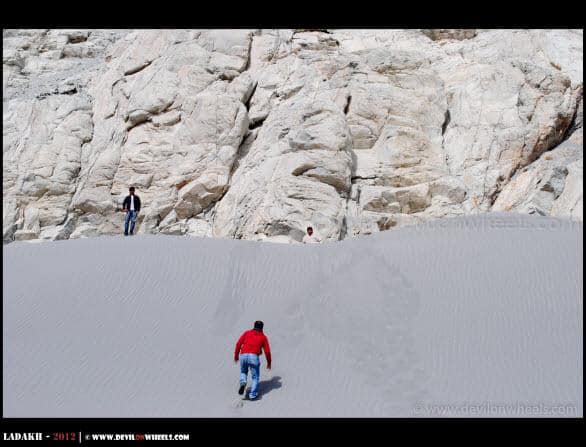
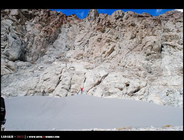
What About the Sand Dunes on the Shyok Route?
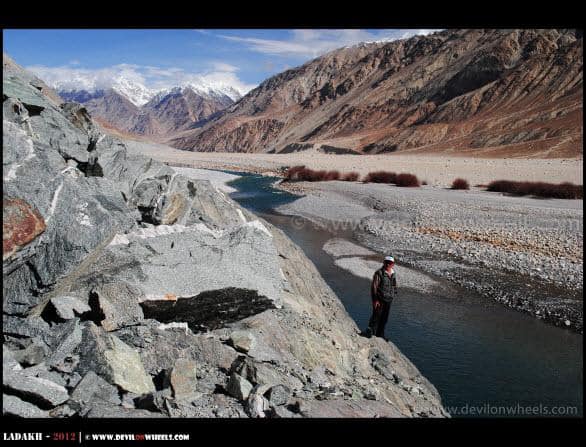
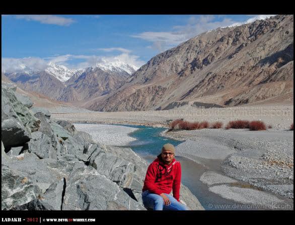
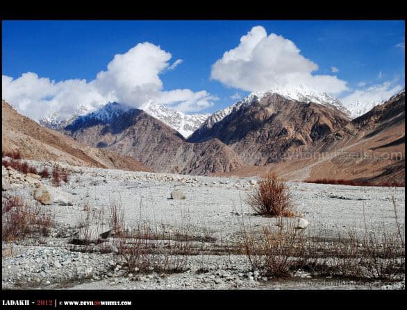
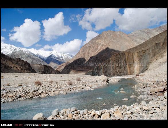
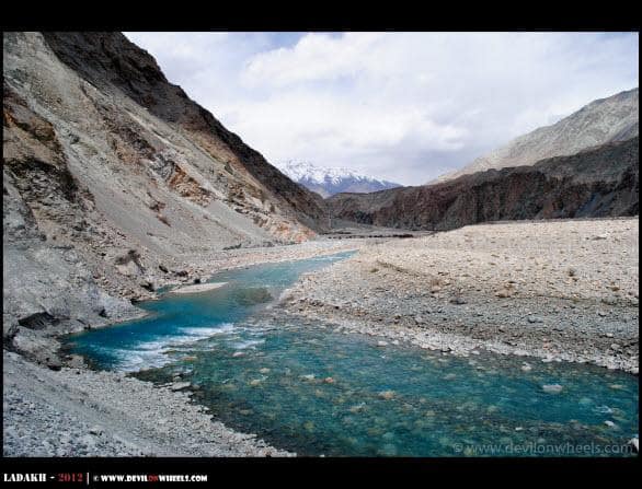
One thing I did not expect on this route was sand dunes, similar to the ones you see in Hunder in Nubra Valley. The route was so fascinating and unpredictable. We stopped beside a huge sand dune which we decided to scale. Slowly, gasping for breath at that altitude, we made it to the top. I cannot explain how it felt. The Shyok river flowing in front of us, we were right at the top of a big hump of sand, everywhere around us was barren landscape, and even the snow-clad peaks of mountains were visible. What a cocktail of natural beauty, and we could not have asked more from this route 🙂
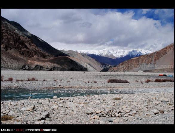
But there was still plenty left for us on this route running alongside the aqua-coloured Shyok river. We met a few Nepali workers who were camping right there amidst a wide piece of land near the river. I distributed chocolates and Poppins among the children as Rigzin had a word with them in the local language. They had been staying there for the last two seasons, working as labourers for maintaining the roads in this part of Ladakh. Imagine their life in winters. Most likely they would trek back to Leh or some other place, but two years in such barren land is hard to imagine.
How Did We Get Stuck in the Sand?
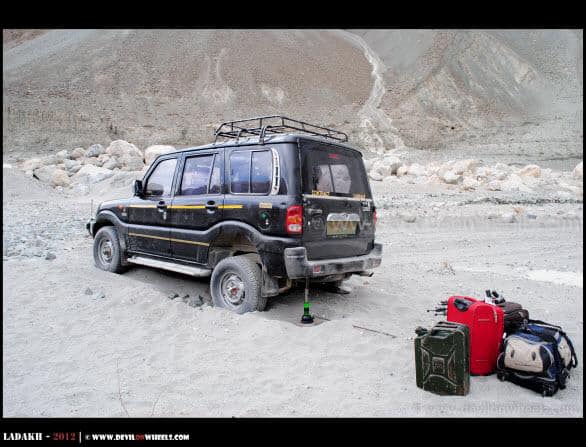
As we moved ahead, there was a very rough road full of sharp rocks. Negotiating those, Rigzin pushed the car onto the dirt track and one wrong move, VOILA! We were stuck in the sand! Badly! It is in a situation like this that you feel how isolated the route truly was. If it had been worse, it would have meant trekking back miles to get help. We were all alone and the funny part was that Rigzin had taken out the shovel from the car before the start of the trip, which meant pulling out sand had to be done by hand only.
The process began. Remove sand below the rear wheel by hand, gather stones, place them beneath the wheels, and give a hard push. The car moved about 1 foot ahead. It was about 12-15 feet from the road and the first attempt had exhausted us, but our spirits were very high still. One more cycle of placing the jack, removing sand beneath, placing rocks, a hard push with throttle, and we inched ahead a few more feet. Hats off to the stamina of Rigzin as we were only playing a supporting role while he did all the hard work. Finally, after the 7th attempt, we were back on road. We hugged each other with joy!
In case you are planning to take this route, I suggest reading my tips on handling water crossings on your motorcycle. Also carry a shovel, tow rope, and basic recovery gear. These are non-negotiable on any remote Ladakh route.
How Dangerous Was the Active Landslide Section?
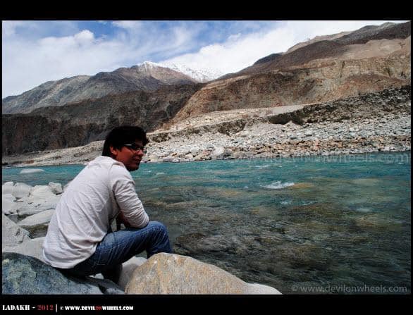
We took out some dry fruits and food from our bags, offered first to Rigzin along with the precious water as we stopped beside the Shyok river. We got stuck mostly due to the low air pressure in the tyre, or perhaps we were just unlucky enough. As we gathered our breath sitting beside the river and gulping the ice-cold water, I realized how serene and calm the whole aura around us was. It was a great feeling, but we did not know that the adventure was not over yet.
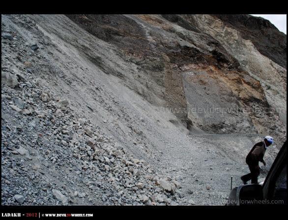
As we moved ahead, there came an extremely bad section on the road with around a 200-feet fall on one side and an active landslide on the other. Rigzin jumped out of the car, removed the rock in front, and moved ahead a bit. Then I jumped out to provide guidance and let him concentrate on the road as rocks were falling from above (happened twice) while I was clearing the path in front. But glad we got out in one single piece. It was a tough and heart-pumping moment. The hardest part was that we could not accelerate because of loose big rocks beneath which did not let the car get the required grip. Thankfully, it was done and again we were laughing at ourselves, thinking was it worth the risk. Well, some questions do not have any answers in adventure!
Safety Note: Please take a sensible call before attempting any route with active landslides. Getting stuck in such conditions is not an adventure. It comes like a nightmare. In case you are ever in such a situation, switch off the engine, wait for the landslide activity to stop, and only then proceed slowly. Always inform someone about your route and expected arrival time before starting. Read more about AMS prevention and acclimatization as well, since this route is at high altitude throughout.
How Did We Finally Reach Nubra Valley?
As we bypassed that rough section, soon we were on the freshly laid tarred road again. We stopped to wash our hands and get a final feel of the remote adventure. Meanwhile, an Army convoy came in and stopped by us. A young Captain came out and asked us where we were going. We said we were not going anywhere, rather coming from Shyok Village! He was in a state of shock and asked us again. When he realized that yes, we had indeed come from there, he told us that they do not cross that active landslide section themselves.
He told us that they wait before the landslide section for their platoon coming from DBO (Daulat Beig Oldie). The other trucks would drop them before that section, from where the soldiers would come walking to the other side. Again, we had a nice chat with the charming guy about our adventure and how they sustain themselves in such harsh conditions. He congratulated us for the adventure we had, and off we went back to the road.
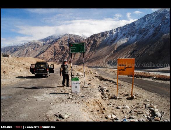
By then the air pressure in the rear wheel had gone down considerably, forcing us to change the tyre. After what we had gone through earlier, it felt like nothing. Within a few minutes we changed it and were back on road to reach Agham Village, entering the known territory of Nubra Valley. Agham is the village in Nubra Valley from where one road leads to Wari La Pass and the other leads to Shyok Village, from where we were coming.

How Has the Shyok Village Route Changed Since 2012?
If you are reading this trip report and wondering whether the Shyok route is still this dangerous, let me give you some good news. The route has changed dramatically since 2012. Thanks to BRO’s continuous work on the strategic Darbuk – Shyok – DBO road (a 322 km all-weather road close to the LAC with China), the entire Agham to Shyok to Durbuk stretch is now largely paved and in decent condition.
As of 2026, the road between Nubra and Pangong via Shyok is the most popular route among tourists. What used to be a full day’s gamble is now a smooth 5 to 6 hour drive covering approximately 160 km. Local taxi drivers now bring even Maruti Alto on this route, which tells you how much the road has improved. However, there are important things to keep in mind.

The Shyok river still floods the road during peak monsoon season, especially in late July and August. When this happens, the route gets closed temporarily, sometimes for days. Hence, always check the current status before you plan to take this route. The Nubra to Pangong direct route guide on this blog is updated regularly with latest conditions.
Shyok Route: 2012 vs 2026 Comparison
| Aspect | 2012 (My Trip) | 2026 (Current) |
|---|---|---|
| Road Surface | Mostly unpaved, river bed in parts | Largely tarred, some stretches under repair |
| Drive Time | 8-10 hours with stops and obstacles | 5-6 hours |
| Vehicle Needed | SUV/4×4 mandatory | Any high ground clearance vehicle works |
| River Crossings | Multiple, dangerous | Bridges built, rare crossings |
| Mobile Network | Zero coverage | Jio/Airtel postpaid near villages |
| Traffic | We saw nobody for hours | Regular tourist and Army traffic |
| Fuel | None available on route | Still no fuel pump on route, carry extra |
What Practical Tips Should You Know for the Shyok Route in 2026?
Even though the road has improved significantly, this is still a remote stretch in Ladakh. Here are some practical tips from my experience and from what I have gathered from DwD community members who have driven this route recently.
- Fuel: There is no fuel pump between Khalsar and Durbuk/Tangste. Fill up your tank in Leh or Diskit before starting. For detailed fuel pump locations, check my article on fuel availability in Leh Ladakh.
- Permits: You need an Inner Line Permit (ILP) for both Nubra Valley and Pangong Tso. As of 2026, the environment fee is Rs 400 per person (one-time) plus Rs 20 per day ILP fee. Apply online through the Ladakh permits guide.
- Best Time: June and September are the best months for this route. July and August carry the risk of river flooding. October is fine if the road has not been closed for winter yet.
- Vehicle: Any vehicle with decent ground clearance will manage in 2026 conditions. However, I would still recommend an SUV if you are driving in monsoon season. Self-drive tips are covered in my 7 useful tips for self-drive to Ladakh.
- Carry Essentials: Water, dry fruits, snacks, basic medicines, a shovel, tow rope, and a spare tyre. There are no shops or mechanics on this route.
- Acclimatization: The route stays above 10,000 Ft throughout. Make sure you have spent at least 2-3 days in Leh for acclimatization before attempting this drive.
- Taxi Rates: A private taxi from Nubra to Pangong via the Shyok route costs approximately Rs 5,000 to Rs 8,000 (as of 2026). Check the latest rates in our Leh Ladakh taxi rates guide.
- Mobile Coverage: Jio and Airtel postpaid connections work near villages like Shyok and Agham, but you will lose signal on stretches in between. Read more about mobile phone connectivity in Ladakh.
What Is the Best Itinerary to Include the Shyok Route?
If you are planning a Ladakh trip and want to include the Shyok Village route, here is the most common itinerary flow. You can cover this route on Day 5 or Day 6 of a standard Leh Ladakh itinerary, depending on your plan.
Option 1 (Nubra to Pangong): Diskit/Hunder – Khalsar – Agham – Shyok Village – Durbuk – Tangste – Pangong Tso (approximately 160 km, 5-6 hours)
Option 2 (Pangong to Nubra): Pangong Tso – Tangste – Durbuk – Shyok Village – Agham – Khalsar – Diskit (same distance, reverse direction, which is what we did in 2012)
Both directions are equally scenic. However, if the Shyok route is closed due to river flooding, the alternative is the Wari La route which adds about 70 km and 3-4 hours. In case you want to go from Pangong to Tso Moriri via the direct route, that is a separate road altogether via Chushul.
The Journey Ahead
After reaching Agham and entering Nubra Valley, we headed to Panamik to visit the sacred Yarab Tso Lake. You can read about that in the next part of this travelogue:
Related Reading
- Nubra Valley to Pangong Tso Direct Route – Tips and Road Conditions
- Nubra Valley Complete Travel Guide
- Pangong Tso Lake – Complete Travel Guide
- Best Time to Travel Ladakh and Zanskar Valley
- How to Get Ladakh Inner Line Permits Online
I hope this trip report and the practical information is useful for fellow travelers planning to take the Shyok Village route in Ladakh. It was one of the most adventurous days of my life, and even though the roads have improved so much since 2012, the beauty and remoteness of this stretch is something that stays with you forever. If you have done this route, do tell me about your experience in the comments section below. In case you know someone planning a Ladakh trip, feel free to share this article with them 🙂 …
For other travel-related details, queries, and discussions, feel free to visit the DwD Community and check the DoW Travel Calendar from the main menu of the website.
Frequently Asked Questions
Is the Shyok Village route safe to drive in 2026?
Yes, the Shyok Village route is much safer in 2026 compared to what it was a decade ago. BRO has built proper roads and bridges on most sections. However, the Shyok river still floods parts of the road during late July and August, causing temporary closures. Always check the latest road status before starting and carry basic recovery gear.
What is the distance from Nubra Valley to Pangong Tso via Shyok?
The distance from Diskit (Nubra Valley) to Pangong Tso via the Shyok route is approximately 160 km. The drive takes about 5 to 6 hours in normal conditions. This is roughly 70 km shorter than the alternative Wari La route.
Do I need a separate permit for the Shyok Village route?
No separate permit is required for the Shyok stretch between Nubra Valley and Pangong Tso. Your standard Inner Line Permit (ILP) covering Nubra Valley and Pangong Tso is sufficient. As of 2026, the ILP costs Rs 20 per day and the environment fee is Rs 400 per person (one-time).
Can a sedan or hatchback handle the Shyok route?
As of 2026, the road has improved enough that even sedans and hatchbacks can manage it during clear weather. Local taxi drivers now use Maruti Alto on this route. However, if you are driving during monsoon season (July-August), an SUV or vehicle with higher ground clearance is recommended due to the risk of water on the road.
Is there any fuel pump on the Shyok Village route?
No, there is no fuel pump on the entire Shyok route between Khalsar and Durbuk/Tangste. You must fill up your tank in Leh or Diskit before starting. The nearest fuel pumps are in Leh (about 120 km from Shyok village) and at select locations in Nubra Valley.
What is the best time to drive the Shyok Village route?
June and September are the best months for the Shyok route. In June, the snow has melted and the river levels are moderate. September offers stable weather and lower water levels. Avoid late July and August when snowmelt causes the Shyok river to flood the road. October is possible if winter has not set in early.

What is the taxi fare from Nubra to Pangong via Shyok?
A private taxi from Nubra Valley to Pangong Lake via the Shyok route costs approximately Rs 5,000 to Rs 8,000 for a one-way drop, as of 2026. The exact fare depends on the vehicle type, season, and your negotiation. Check the DwD Ladakh taxi rates page for the latest updated fares.
Is there mobile network coverage on the Shyok route?
As of 2026, Jio and Airtel postpaid connections work near villages like Shyok and Agham with decent data speed. However, there are stretches between the villages where you will lose the signal completely. BSNL coverage is patchy. Prepaid SIMs generally do not work in Ladakh. For full details, read the mobile connectivity in Ladakh guide.
44 Comments
Comments section gets closed in 90 days. To ask your travel questions, you can follow my YouTube Channel for a faster reply or for a much slower reply follow me on Instagram. :)
We know whachu talking about! We took the same route but during off season.
Take a look – bit.ly/Ladakh2016
hi everybody………just back from ladakh trip and covered agham to shyok on RE classic 500…..GROUND 0 condition………..pl dont take this route as the pics displayed are very good than the actual condition of the road as of 7 june 2013…………road till agham from khalsar is very good but the moment you take the left turn for shyok village the real fun starts…..bumpy ride till first 14 kms but easy…..then there is a landslide zone and we were the group of 3 bikers and all the bikes needed to be lifted to climb an almost 90 degree cliff of rouhjly 10 feet…..after crossing that river stones are all over the place and no track of road for further 5 kms ……and all of a sudden you see shyok rver right in front of you with a Z type of crossing…….first one is shallower with 2 feet deep but huge and loosely packed stones on the river bed that dont allow the essy negotiation and took a huge toll on bike chasis…….2nd river crossing is a bit deeper with 3 feet to 3.5 feet deep but smooth at bed…….but this shallow track is only 8 feet wide and if you loose the track by mistake with the flow you get urself into 5-6 feet deep zone…….sounds normal but scary in reality…….after river crossing next 5 kms again bumpy but dirt track there……..and then you find the tarmac road till shyok and further to durbuk……but lot of water crossings in the middle but managable………we were at agham 1:30 PM and shyok at around 7:30 PM…
Siddhartha, thank you so very much brother for this timely update and whoaaa… what an adventurous ride. In that landslide zone, I was running ahead as there was stones coming down, clearing those stones so that our car moves. It was indeed scary that time but you know now how it feels…. Yes, the route is not something to be taken easily, that is why never recommend to people especially with family. When you are actually there it looks like a crazy decision. Also, if something goes wrong, you are into big trouble and on your own!!
If possible, try and share your Himalayan Travel Tale or experience with us at DoW – Himalayan Travel Community. It will help many others find the information in structured way and would be more useful to all travellers.
I m looking to explore the Pathankot-Basohli Bani Bhaderwah Anantnag Srinagar stretch. Any tips ?
Kindly mail me atul292@gmail.com
Sorry Atul, not been on that route.
Dear Sidhhartha…
Was the river too deep in these two crossing. What about the ECU of the Classic 500…..a bit of water inside and they say that the electrical will malfunctions? Did you take out the ECU and then Manually pulled it in the crossing? Or was any modifications made ?? Btw I am trying to get through this route this June…. may be……your points will really help a lot.
Thanks and Regards
Rahul
Just came back from Ladakh last week. Thanks a lot to DoW for providing all information required for this trip. We took this route from Nubra to Pangong via Shyok as I did not want to cross Khardungla and Changla and spend n extra day. I got an excellent driver by name Karma Sonam( contact 9419215110, 9906991011) who is not only an expert driver but also a great travel companion, guide and a very good human being. He has been quite familiar with the Shyok route and he agreed to take us through the route. We traveled on 24th May, 2015 and Karma confirmed that there will not be any water on the road. The route is one of the most scenic routes in Ladakh with beautiful blue Shyok river beside you for most of the journey. It is also a journey of a lifetime as you will be driving on the river bed in may places. As it seemed the road got destroyed in landslide in a few places (and there has not been any attempt to repair it for quite sometime). Karma has been quite familiar with the detour. But remember we saw only one car in 4 hour ride to Durbuk.
It is a journey worth taking if you are adventurous and travelling in summer and have a very confident driver like Karma. I actually traveled with my parents (80 and 70 year old), my sister, wife and son( 12 years old).
Thank you Partha for updating the road condition and highlighting the desolation of the route. Glad you were able to do that route and yes, completely agree that it is one of the most scenic routes in Ladakh espcially around Shyok village. I have updated the driver list with your review.
Hello Partha,
Thanks for the review. Can Karma help us in finding cheap accommodation in and around Leh? Do you have any idea about it?
Most of the drivers does help in finding small guest houses. You can tell them your preferences and most of these guys in Ladakh are geniune and does not work like agents or take commissions, they genuinely help
So Ankit, you think we should remove Karma from the list?
He called me and was very apologetic about his lack of judgement to tag us with other untrustworthy drunk driver. We should downgrade him and should give home one more chance to prove himself.Thanks for your quick response.
Good to know that,thanks for the update Ankit.
I just did that magnificent route in Nissan Micra. Drove from Pune to Pangong. The best I enjoyed was dthe drive along the Shyok from Agham…terrific and magnificent…
Thanks for the update Vimal, well, you did it in time. The part of route has started being submerged now in the late hours of the day. Soon it will be submerged in Shyok river in few days for the season.
awesome yaar . . . but how much time will it take from nubra valley to pangong via shyok village.. and we are plannig to take force traveller . . ! is that car capable of doing this ?
not actually CAR its a MINI BUS !
Ayaz, as you can see and might have read this is one of the most isolated places in Ladakh and even local taxi drivers fear to drive there. Time taken about a=be approaximately 6-7 Hrs from Nubra Valley to Pangong Tso via Shyok Village but if you are stuck then you are all alone in this terrain. It also depend if the route is open or not because generally it closes every year due to landslides starting June.
hi dheeraj…….you are very right as in starting june the road for approx 15 kms is terrible with 5 kms almost impossoble due to landslide and two river crossings……..but hats off to you that you managed to take some real good shots of the route……..
Thanks alot brother, this will surely help many people looking for this route and make their decisions!! 🙂 🙂 … If you find time, please do share your complete experiencealong with some pics with us at DoW – Himalayan Travel Community
dheeraj bhai wt a fantastic adventure u hv …. BTW wt is the actual distence of bad patch??? between shyok and agham?
Vikas, thanks alot. The distance of the bad patch is about 4 – 5 KMs and there are couple of such patches but mangeable. The scariest one is about 600 – 700 Mtrs or may be a KM only.
Dheeraj – Quite an adventure! and some smashing images there! As a photography enthusiast, I was wondering how much of SD card memory would be good on a 5 day trip to Ladakh? I have 32 GB at my disposal right now, do you think that should take care of the trip if I were to go ballistic clicking pictures? and how about batteries? At Nubra – at the hotel/guest how will it be possible to re-charge O/N?
Cheers
SG
Thanks alot SG. Yes, it was one of the great adventure of my entire Travel. 32 GB is more than enough sir,I had just 16 GB and came back with 12-13 about 2.5K pics of which discarded almost 50%. So, 5k in 5 days seems large number to take stats into account 😀 … Anyways, I feel should be enough. I used to carry two with me. Most places do have electricity including Nubra Valley. Only at Pangong Tso, you will not get electricity else everywhere you are staying.
I hope this helps. Let me know incase you need more info. or have any queries or doubts.
Sorry for the delayed reply.
Regards
Dheeraj Sharma
Wow..lovely pics..and great narration! Thank you Dheeraj:)
Thanks alot Amit , glad you liked the pictures and narration…
Regards
Dheeraj
Good lessons in how to use jacks to get your car out of the sand after it had sunk in! Do you need to mention Shayok specifically in the permit? How much time did it take from Shayok to Agham? Is any permanent improvement in the condition of the road expected or will it continue to be a Jun-driveable road?
Thanks alot HVK sir. Nopes, we did not mention Shyok Village on the permits and neither we found any barricade or post which checked for the permits. It took about 5-5.5 Hrs from Tangste including an hour or so wasted in Tyre sunk issue and puncture. And, as far as what I saw there I cannot see Shyok village route be open in months of July and August when water crossing are ferocious due to rapid melting of snow as well as little more rain that Ladakh has started getting now. The whole new road cut through the mountain after 2010 flashfloods are almost on the river bed and if the water level rises in the Shyok river then definitely it is bound to be closed. Also, that continuous landsliding section is just too dangerous even in dry conditions and would be worse in wet conditions.
So, most like it would remain as upto June drivable for sometime now though they had definite plans to keep it open through out the season.
Regards
Dheeraj Sharma
Wonderful photographs , for us to admire. Awesome account of landslide road crossing. Adventure, yes, thank God everything went well.
Thanks alot Pattu and yes, that as one scary moment of the whole trip apart from other following in the posts to come 😀 … Thank God all went well and yes, of course this is what we go there for… some what fun and adventure, a bit deviation from day to day monotonous life and suddenly you feel you are too small in front of mother nature. Thanks for liking the pictures as well…
Regards
Dheeraj Sharma
Hi dhreeraj. I am just glad reading your fabulous time,need little help about current road condition ok or not till udhampur Srinagar highways till Kargil?I am connecting from Delhi from 25th Aug 2012 on bikes.
Hi Shashank,
Yesterday itself, I got a call from one couple who were driving through Srinagar – Kargil and they reported that things are OK to drive though roads are not that good and especially when they inquired about Manali – Leh Highway, the slush conditions between Marhi and Rohtang Pass is pretty bad. They did not face much issues over Zozi La but yes, definitely some rough sections.
I hope this helps. Let me know incase you need more info. or have any queries or doubts.
Regards
Dheeraj Sharma
Superlike 🙂
Ekdum zakas!
Shyok has really fantastic colors man and u captured best of its color!
I m confused now after reading this one can’t dare to go there alone but picts are really pushing me to visit that route!
hi Swapnil,
Thanks Brother!! But, actually since I last heard the Shyok Village route is all closed due to slides and water over the roads. Not sure, things will improve before late season or early next season on this route as you might be able to predict by the road conditions shown in the pictures 🙂
Regards
Dheeraj
We are booked from Srinagar – Leh by Xylo next week. Looking at the flood situation, how safe is it to go there?
We leave srinagar on 12th aug and reach Leh on 13th stopping at Kargil on the way.
How slippery will the roads be? we are a group of 5 family members ages ranging form 17-50.
We reach back to srinagar by the same route after a week in Leh, taking in Nubra and pangong.
Should I go ahead with this trip this time or choose some other alternative, looking at the floods there currently?
Hello Jayashree,
It is not a flood but a flash flood that comes and goes away. These things are part of journey in monsoon time and if you are really worried I will suggest that you postpone it post-monsoons. It is monsoon time and at some parts of Manali – Leh Highway (like before Baralacha La) and Srinagar – Leh Highway (like before Kargil) you might need to face monsoon hassles but once you get closer to Ladakh, then Ladakh being rain shadow region is least affected by monsoon rains, though rains does reach Ladakh now but to minimum and mostly it might remains overcast conditions. There is no thumb rule of certainity about weather conditions but above is generally common pictures seen over last few years except ugly 2010 …
Generally, for normal landslides, hats off to BRO + GREF guys they clear these roads within a day or two to resume traffic. So, go mentally prepared, if going and have few buffer days for sure.
I hope this helps. Let me know incase you need more info. or have any queries or doubts.
Regards
Dheeraj Sharma
Awesome bhai ji missing my Nubra tour
Thank you brother, how about Zanskar then in September 🙂
Regards
Dheeraj
India at its best….No one can imagine that these kind of places are in India…..what a place…..
Surely it is, Nitin. It was an awesome place to be in and we had full blast over there 🙂
Regards
Dheeraj Sharma
lovely been last month in ladakh
Thanks Amit, did you go over the Shyok Village route. It is quite scenic, dangerous and adventurous too 🙂
Regards
Dheeraj
वाह भाई, फ़ोटो के साथ विवरण ने समां बांध दिया है। GREAT DETAIL.
Thanks alot Sandeep bhai… Is se zada adventurous road kabhi nhn kiya. First time in life, hum log live landslide mein pather uda uda kar side kar rahe the aur car aage chalti jaa rahi thi. Aaj bhi dil baid jata hai us moment k baare mein soch kar 😀
Regards
Dheeraj