
The direct route from Nubra Valley to Pangong Tso via Agham and Shyok Village is one of the most talked about stretches in all of Ladakh. Thanks to years of relentless work by the Border Roads Organization (BRO), what was once a barely-there track along the Shyok River has become a viable, time-saving route that connects two of Ladakh’s crown jewels without the need to backtrack to Leh. I drove this route in 2018 and have been tracking road improvements ever since. In this guide, I will share my first-hand experience, updated road conditions, distances, travel tips, and everything you need to plan this drive in 2026.
Let's quickly dive into the details:
What Are the Two Route Options from Nubra Valley to Pangong Tso?
There are two direct routes connecting Nubra Valley to Pangong Tso. The shorter and more popular one goes via Agham and Shyok Village along the Shyok River. The longer alternative crosses Wari La Pass before joining the Chang La route to Pangong. Here is a quick comparison.
| Route | Distance | Travel Time | Difficulty |
|---|---|---|---|
| Agham-Shyok Route (Direct) | ~162 km | 5-6 hours | Moderate (river crossings, narrow roads) |
| Wari La Route | ~222 km | 8-10 hours | Challenging (17,300 ft pass, longer) |
| Via Leh (Backtrack) | ~360 km | 10-12 hours | Easy roads, but wastes a full day |
Most travelers in 2026 prefer the Agham-Shyok route because it saves an entire day compared to backtracking through Leh. The Wari La route is a solid backup if the Shyok road is closed due to river flooding, which can happen during July and August.
Video – Nubra to Pangong Tso Direct Route
What Is the Complete Distance and Time Chart for This Route?
Knowing the exact distances between stops helps you plan fuel, breaks, and daylight hours. Here is the segment-wise breakdown for the Agham-Shyok direct route from Hunder (Nubra Valley) to Spangmik (Pangong Tso).
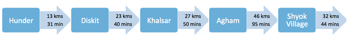

The total distance from Hunder to Spangmik via the Shyok route is roughly 162 km. If you are starting from Diskit, add about 10 km. From Panamik or Sumur, the distance increases to around 170-180 km. Keep in mind that the travel time of 5-6 hours is under normal conditions. Landslides, river crossings, or military convoys can add 1-2 hours easily.
What Permits and Fees Do You Need for This Route?
Both Nubra Valley and Pangong Tso fall under restricted areas in Ladakh. You need an Inner Line Permit (ILP) to visit either destination. As of 2026, the permit system has been streamlined into the Ladakh Environment and Development Fee (EDF) system, which you can apply for online before your trip.
Permit fee breakdown (2026): Rs 400 per person (environment fee) + Rs 20 per person per day (wildlife protection) + Rs 10 per person per day (Red Cross donation). For a typical 7-day Ladakh trip covering Nubra and Pangong, expect to pay around Rs 610 per person. The permit check happens right after Durbuk on this route, so keep your printed or digital permits handy.
How Is the Drive from Hunder to Khalsar?
After a wonderful stay in Nubra Valley, our onward journey towards Pangong Tso for a full-moon night started with high expectations. As with any plan in Ladakh, it is always wise to take an early start. If you are concerned about fuel, do make a stop at Diskit, which has the only petrol pump for nearly 300 km.
We had tough luck as the petrol pump had no diesel and asked us to wait for another 2-3 hours for the next shipment. We decided to risk it, knowing fuel in black is available at certain places (more on that below).
The drive towards Khalsar is genuinely beautiful. The road is well-constructed, with a long stretch of straight tarmac followed by bends that are pure joy. Go easy on the smooth roads even though you might feel like doing 100 km/h. Just relax and enjoy the views of the barren mountains alongside the river.
My way of recognizing drives with limited danger in Ladakh is simple. Read the BRO road signs. If they are philosophical and not cautionary, you are on an easy path! My favorite is “simplicity is the peak of civilization”. Ah, BRO, teaching life lessons and connecting hearts, all the while cutting mountains.
Khalsar is a good breakfast and chai pit-stop. Right after Khalsar, a short climb up leads you to an intersection. Keep going straight on this road towards Agham, instead of taking a right turn for Khardung La.
What Changes When You Enter Shyok Valley from Khalsar to Agham?
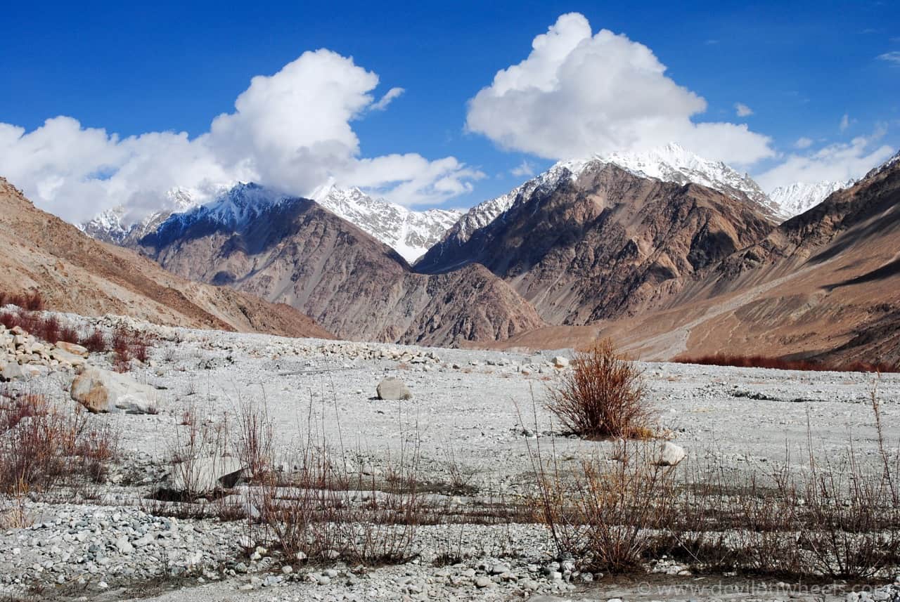
Immediately upon leaving the familiar route, the scenery changes completely. Having left behind Nubra Valley, while entering Shyok Valley you notice a different kind of beauty. I strongly think one should not take this route just to save time, but rather to experience views unlike any other valley in Ladakh.
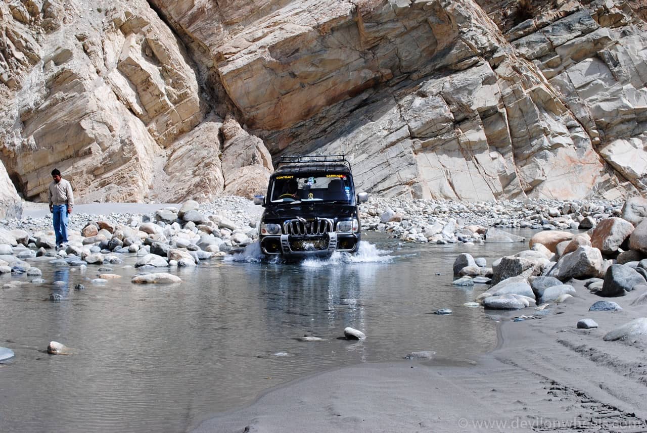
In one moment, you will be driving next to the river bed, sometimes on the river bed itself. The next moment, you will be on a steep climb with many hairpin bends. This entire route will lead you up and take you back to the river multiple times.


A majority of the route runs alongside the Shyok River, literally meaning “the river of death”. This river is known for its unpredictability. There are even local songs about the destructive powers of this river. Make no mistake, you need to be alert about two things: the river flow and the landslide-prone mountains.
Even if you are planning a trip to Ladakh in winters, you should inquire about road conditions from the locals in Agham village before moving ahead. Frankly, I will not recommend this direct route between Nubra and Pangong Tso via Shyok in winters at all.
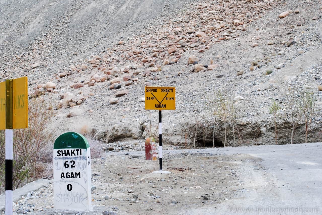
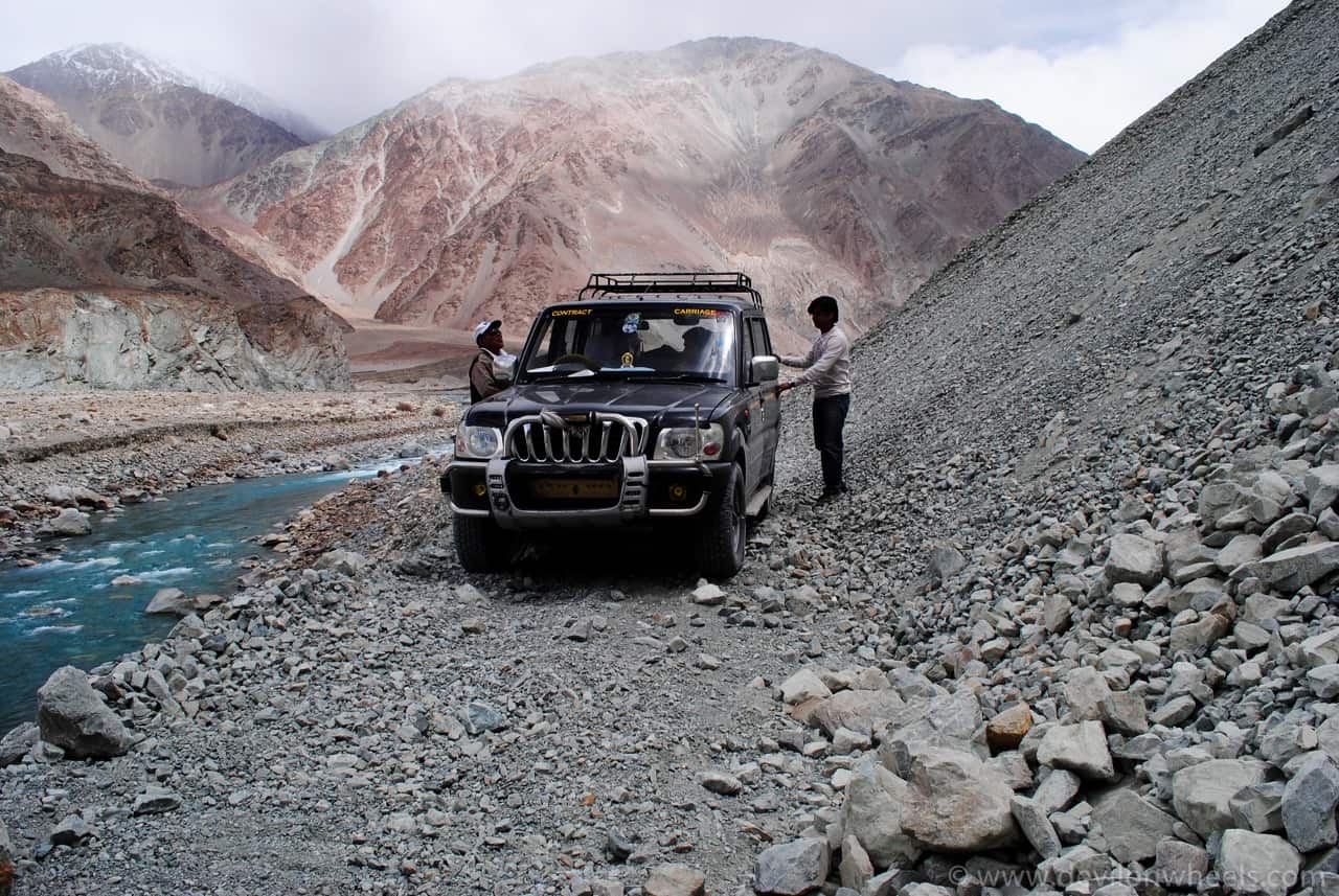
At Agham, do ensure you speak with onward traffic by stopping a few vehicles and confirming whether the route is fine, especially if it is about to rain. This route witnesses frequent landslides, and it might be better to spend an extra 2 hours by taking the Wari La route than getting stuck in the middle of nowhere. There is hardly any vehicular movement, and you might be pressed for luck to find any soul to help you out. Proceed with caution.
At Agham, you will need to take a left towards Shyok.
What Makes the Agham to Shyok Village Stretch So Tricky?
This is the most adventurous section of the entire Nubra to Pangong direct route. A little distance ahead of Agham, you will find a road sign pointing left for the Pangong Tso route. Now, this is a very easily missable sign. It is hand-painted and points towards the river bed, mostly hidden by wild flora. You might not think this is the way, but it is.
Do not miss this sign. Take the left. Yes, the dried-up river bed IS the road you will now be driving on!
Once you cross the river bed (be careful about sharp-edged stones), you are on the next mountain. After this, the route continues in a mixture of well-constructed stretches and passages through riverbeds.
The curves are not difficult to maneuver but are frequent, and the roads are exceptionally narrow. Any onward traffic might make giving way slightly problematic. From personal experience, we encountered maybe 10-15 bikers and a handful of vehicles (mostly local taxis) on our way. This density has increased in recent years as brand new bridges over the river have made this route more commercially viable.
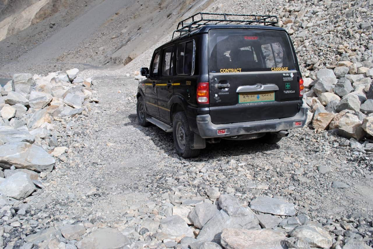
Right after the difficult patch, you start on a smooth road that stretches for about 10 km, right in the middle of the riverbed. It is such a surreal experience. You are all alone, on a smooth road, no civilization, no wildlife, almost no vegetation. Just you, cruising on a dried-up river bed.
The mountains are daunting and you feel inconsequential in front of the mighty hills. The newly constructed roads limit your worries to a certain extent. You can even find dhabas on the Agham-Shyok Village stretch now, right after crossing the halfway mark. Basic amenities of Maggi, soup, and chai are readily available.
Upon reaching Shyok Village, you will spot lots of little farms, a delight to see after hours of barren mountains next to a gloomy river. There is a small Gompa right after crossing the village. The village itself seems like it has been picked up from some other corner of Kashmir and placed in the middle of literal-nowhere. You also start spotting signs of development here, with electricity poles that do not quite match the zen-like views.
A little further ahead, the Shyok River flowed underneath one of the newly installed bridges and made for a nice place to chill and unwind. With the weather slightly unpredictable and grey, we experienced a pleasant drizzle after Shyok. We relaxed here, contemplated life, ate munchies, and chilled for a very long time. Only when it started to drizzle a bit more did we realize we had miles to go.
Always carry your water bottle and refill it as many times as you need. It will not only keep you hydrated, but you will also help in saving the Himalayas from plastic garbage. Remember, every tiny step counts and your step in this direction can help save the Himalayas too 🙂 🙂
What Can You Expect on the Shyok Village to Durbuk Stretch?
Shyok to Durbuk is a scenic drive. Leaving behind the scary-looking mountains, which we renamed as the “cookie mountains” (I am using the word mountains loosely, as these hills are made of stones of all shapes and sizes, held together by soft mud), was a relief. Spotting wildlife here is easily my favorite part of the trip.
The cookie mountains are scarier than the Cookie Monster. They truly looked like cookies with extra nuts stuck on top. You could pull one of those rocks out so easily! I am sure a little rain and these mountains would just slip down. The mountains have a way of making you feel vulnerable and at ease at the same time. We were glad upon reaching the massive rock-solid structures again.
This is also the area where several Bollywood movies have been shot, including Jab Tak Hai Jaan and Highway. Horses, yaks, goats, and sheep are all delightful to spot along the way. Road signs tell you not to feed them.
Expert Travel Tip: If you are self-driving to Ladakh and taking the route from Nubra Valley to Pangong Tso, then make sure you are prepared with the 40 must-have things for a Ladakh self-drive trip.
This particular drive alternates between greenery (mostly around the river flow) and barren mountains. Pure joy! Be prepared for sharp bends in some parts.
How Is the Final Stretch from Durbuk to Pangong Tso?
At Durbuk, the road from Leh towards Pangong joins our route, and things become more commercial. Instead of stopping at Durbuk for your snacks, I suggest moving slightly ahead to Tangtse, where you will also be able to stock up on fuel (available in black with the dhaba owners). There is also a beautiful monastery atop a hill that is extremely serene. Try stopping if you can, or make it an agenda item for the return trip.

The stretch of road to Lukung is easy. You are in a large military area, and a lot of places prohibit photography, so do keep an eye out for the signs. One thing I truly appreciated was spotting Army officers and jawans throughout my route and how friendly they were. They enjoyed sharing advice, striking up conversations, and getting to know the travelers.
There is also a stretch called Pagal Nala that you might encounter somewhere after Tangtse. Also, Chagar Tso, about 15-20 km before Pangong, is a delight. It is a small lake with pretty spectacular views. We were far too excited for the real deal and did not stop here. If you do, you might be able to spot some marmots as well.
So close to the destination, and you hit a rough patch of road. It has to be said that Ladakh roads do make you earn your sights. This stretch ensured the driving was dramatic, the roads were thin, and our excitement was beyond measure.
However, this small stretch was almost forgotten when we saw that first glimpse of blue. The blue was so blue, it was the definition of perfect blue. Driving next to the lake for a stretch of 10 km before reaching our camps was M-A-J-E-S-T-I-C. Meaning “long enchanted lake” in Tibetan, Pangong Tso cannot be described in words. No picture has ever done it justice. It must be visited to be appreciated.
How Much Does the Nubra to Pangong Route Cost by Taxi in 2026?
If you are not self-driving, here is what you can expect to pay for a taxi on this route. These are approximate rates as of the 2025-2026 season. Always confirm the latest rates from the Leh Ladakh taxi rate list or your hotel in Leh.
| Option | Approximate Cost (2025-2026) | Notes |
|---|---|---|
| Private taxi (Nubra-Pangong via Shyok) | Rs 10,000 – 12,000 one-way | Part of Leh-Nubra-Pangong-Leh circuit |
| Full circuit private taxi (3 days) | Rs 16,000 – 20,000 | Covers Leh-Nubra-Pangong-Leh |
| Shared taxi per seat | Rs 4,500 – 9,000 per person | Subject to availability, peak season bookings |
The most cost-effective approach is combining Nubra and Pangong into a single 3-day circuit instead of booking separate taxis for each destination. This saves you one full day of taxi booking and avoids backtracking to Leh. Feel free to check our Ladakh taxi and self-drive FAQs for more details.
What Are the Essential Tips for the Nubra to Pangong Direct Route?
Based on my personal experience and years of feedback from the DwD community, here are the most important tips for this route.
- Search for Spangmik on Google Maps, not Pangong Tso. All campsites and accommodation options near Pangong lie on the Spangmik side.
- Watch for the hand-painted sign at Agham. When you reach Agham, keep your eyes peeled for a small hand-painted sign that reads “Pangong Tso” pointing left. Do NOT miss this sign. At this point, you take a left and drive onto the dried-up river bed of Shyok.
- Stock up on fuel at Diskit. The Diskit petrol pump is the only fuel station for nearly 300 km. It is not always reliable, so top up your tank completely. Black market fuel is available at dhabas in Tangtse, but at inflated prices.
- No mobile network on this route. As of 2026, Jio 4G works at select points near Durbuk and Tangtse, and BSNL has intermittent coverage near villages. But between Agham and Shyok Village, expect zero connectivity. Download offline maps before starting.
- ILP/EDF permit is mandatory. You can apply for the Ladakh permit online before your trip. Permit checking happens right after Durbuk.
- Avoid this route after dark. The narrow roads, river crossings, and absence of any lighting make night driving extremely dangerous on this stretch.
- July-August monsoon caution. The Shyok River can flood the road at multiple points during peak monsoon. Always ask locals at Agham about current conditions before proceeding. If the Shyok route is closed, take the Wari La alternative.
- Carry basic spares and tools. A puncture kit, tow rope, and extra fuel are non-negotiable. There are no mechanics between Khalsar and Durbuk.
What Is the Best Time to Take This Route?
The Nubra to Pangong direct route via Shyok is open from approximately May to October each year. The best months are June and September, when the weather is stable, the river levels are manageable, and the road surface is in its best condition post-BRO maintenance.
July and August bring monsoon rains. The Shyok River can rise rapidly and submerge sections of the road. In July 2025, for example, the route was temporarily closed when the river flooded the road at several points. If you are traveling in peak monsoon, always have a backup plan to go via Wari La or backtrack through Leh.
October is beautiful but cold. By late October, the route typically closes for the winter. In case you are visiting Ladakh in winters, this route is simply not an option.
Where Can You Stay Near Pangong Tso in 2026?
Most accommodation near Pangong Tso is clustered around Spangmik, Lukung, and Man villages. Camping directly on the lake banks has been restricted by local authorities to protect the fragile ecosystem. Here is a rough idea of costs for the 2025-2026 season.
- Budget camps (Spangmik): Rs 2,500 – 3,500 per person per night (includes meals)
- Mid-range camps (Lukung/Spangmik): Rs 4,000 – 5,700 per person per night
- Cottages and guesthouses: Rs 3,000 – 6,000 per room per night
Booking in advance is strongly recommended during peak season (June-September). For detailed reviews and options, check the Pangong Tso accommodation guide.
Frequently Asked Questions
Is the Nubra to Pangong direct route safe for bikes and motorcycles?
Yes, the Agham-Shyok route is doable on a motorcycle, and many bikers take this road every season. However, you need a bike with good ground clearance (Royal Enfield Himalayan or similar) because of river bed crossings and loose gravel patches. Riding solo is not recommended. Travel in a group or at least with one companion vehicle.
Can I take a sedan or hatchback on this route?
I would not recommend it. The river bed crossings, loose stones, and narrow mountain roads require a vehicle with high ground clearance. An SUV or a 4×4 vehicle is the safer choice. If you only have a sedan, consider taking the Chang La route via Leh instead.
Is there any public transport from Nubra to Pangong?
There is no direct public bus service from Nubra Valley to Pangong Tso. Your options are a private taxi, a shared taxi (if you find other travelers willing to split costs), or your own vehicle. For budget travelers, check the Ladakh public transport and budget travel guide for alternative ways to reach both destinations from Leh using the Leh to Nubra bus service and the Leh to Pangong bus service separately.
How much fuel should I carry for this route?
From Diskit to the next reliable fuel availability (Tangtse, in black market from dhaba owners), the distance is roughly 120-130 km. Your vehicle should have at least 15-20 liters of fuel to be safe. If your vehicle is not fuel-efficient, carry an extra jerry can. Read our detailed guide on how to carry extra fuel safely.
What if the Shyok route is closed? What is the alternative?
If the Agham-Shyok road is closed (common in July-August due to river flooding), you have two alternatives. The first is the Wari La route (Agham to Wari La Pass at 17,300 ft to Sakti to Chang La to Pangong), which adds about 60 km and 3-4 extra hours. The second is to backtrack to Leh and take the standard Chang La route to Pangong, which takes a full extra day.
Do I need a separate permit for Nubra and Pangong?
No. A single Ladakh ILP/EDF permit covers both Nubra Valley and Pangong Tso, along with other restricted areas like Tso Moriri and Hanle. Just make sure your permit lists all the areas you plan to visit when you apply. The permit can be applied for online before your trip.
How are the road conditions in 2026?
BRO has improved this route significantly over the past few years. The Agham-Shyok stretch, which was once mostly a river bed track, now has proper tarmac in many sections and new bridges over the Shyok River. That said, sections between Agham and Shyok Village remain prone to landslides and river flooding, especially during monsoon. The stretch from Durbuk to Pangong is in good condition year-round.
Do you still have any questions about the Nubra to Pangong Tso direct route? Feel free to drop them in the comments below or reach out on Instagram. You can also connect with fellow travelers in our DwD community and discuss your upcoming Ladakh trip plan. If this guide helped you, please share it with anyone planning a trip to Ladakh 🙂
Have a travel question?? You can subscribe to my YouTube channel and leave a comment to ask your travel questions about traveling to the Himalayas.
Last Updated: February 2026
10 Comments
Comments section gets closed in 90 days. To ask your travel questions, you can follow my YouTube Channel for a faster reply or for a much slower reply follow me on Instagram. :)
Hi Dheeraj isbit possible to travel Nubra to leh via Pangong in a single day with taxi??
If yes then kindly suggest us the route and plan.
Ashish, when you say possible, yes, it is possible to travel. It will take about 6 hrs to reach Pangong Tso from Nubra Valley and then further to Leh from Pangong Tso another 6 hrs.
Hi Dheeraj we are 6 persons and will be reaching keh on 25 sep and our return flight is on 1 Oct.
We are planning to visit Nubra and Pangong in first 3 daya i.e. 26-28 sep. And Kargil war memorial on 29-30 sep.
Kindly guide us with the itinerary or any changes we should go with.
Hmm, Ashish, you should plan like below:
Day 1 | Delhi – Leh (By Flight)
— Checkin at Hotel. Many hotels provide free pick and drop from Airport. Ask while you book them.
— Take ample of rest as well as water or anything that keep your body hydrated enough. DO NOT OVER HYDRATE. Take ORS Soluted water or ORS – L tetra packs from home.
— Do not over exert your body at any cost. Avoid too much up-down on stairs or avoid it in entirety, if possible.
— After 5-6 Hrs of rest you can visit Leh Palace, Local Leh market, Shankar Gompa .
— If you feel exerted go back to Hotel, have dinner at Hotel and take rest. Avoid any exertion. Else continue and,
— Follow the sunset by stroll at Changspa road and have a nice dinner on varied cuisines offered in-around Changspa road.
— Go back to hotel for overnight stay at Leh.
Day 2 | Leh Local Sighseeing + Acclimatization
— Hire a taxi from Leh taxi stand or Hotel whichever suits you.
— Bargain with taxi driver and you can refer the thread for a comprehensive list of drivers: List of Taxi Drivers for Ladakh – Srinagar – Leh – Manali
— Take his inputs if you feel reasonable and if required modify the plan accordingly but should suits you best.
— Ask him to be with you guys starting first day itself, if required and charged reasonable else do it at your own.
— Again DO NOT over exert and take little steps and slow walks only.
— If feeling OK then do Local sightseeing. To know the about the places to visit check the link: Travel Guide for Local Sightseeing of Leh Town in Ladakh
— Do not use stairs at any of these places just to see them as it will exert your body much more.
— Overnight at Leh
Day 3 | Leh – Khardung La – Diskit – Hunder
— Head for Nubra Valley and stay overnight at Hunder / Diskit
— On the way enjoy a cup of soup at Highest Motorable Pass (as claimed) Khardung La
— Diskit has monasteries with tallest lord Buddha statue and Hunder has sand dunes and bacterian camel safari
Day 4 | Hunder / Diskit – Shyok Village or Wari La – Pangong Tso
— Take direct route to Pangong Tso via Shyok Village (shorter) or Wari La (longer) whichever is open
— Overnight at Pangong Tso
Day 5 | Pangong Tso – Leh, covering Hemis, Thicksey and shey monasteries
— Cover Hemis, Thicksey and Shey
— Overnight at Leh
Then I do not see you have two more days to make it to Kargil war memorial and come back the same day. So, skip it. Visit Hall of Fame in Leh and do Sham Valley tour on Day 6
Hello, Ive just joined this website…needed to know few things
1) From Leh to Pangong and the Tso M lake – how long does it take (return same day)? Being a single lady (Indian) is it safe to hire a jeep with driver? Which company to contact, or do you suggest a safe driver?
2) How much wld it cost?
3) What time shld one leave to have enough time at the lakes to sit, meditate, then return peacefully, no hurry?
4) Think of toward 2/3 Sept – is that time good yet to travel?
Any other advise wld be very welcome.
Thanking you
Sorry, wanted to add – both lakes on separate days not on same day. Thanks, I await your response with gratitude.
Just replied !!
Leh to Pangong Tso to Tso Moriri is at least a three day journey, Leh to Pangong Tso, Pangong Tso to tso Moriri and Tso Moriri to Leh.
1. It would cost about 25000 for the trip. You can call the local drivers directly to connect with them and check the more comprehensive List of Taxi Drivers for Ladakh – Srinagar – Leh – Manali with recommendations/reviews for DoW community members.
Thanks for sharing the information!
I’ve heard that direct route from Nubra to Pangong is closed in September.
Is there any way to confirm this apart from talking to the local taxi drivers before going to the trip?
No Rohit, this route remain open all round the year unless there is some landslide. Once you reach Nubra Valley, check at Agham village or Khalsar village while going from Leh to Hunder so that you can make the plan accordingly next day.